I am beginner of SAR images and Sentinel=-1 Toolbox, i am processing a flood map. I refer to step-by-step user manual, but I am not satisfy with accuracy. Any process I can improve it? And any objective threshold method suggested?
Thank you for your reply.
I followed these steps, but the accuracy is not that good. Any suggestion for improvement?
Some articles suggest to decide threshold by using mean and standard deviation of difference image (flood vs non-flood images). But I am not sure if it can be processed by using s1tbx.
Thanks.
Mei
You can define some AOI over your image and check the local statistics to decide your threshold. More advance approaches use classification instead of thresholding. What is exactly causing your ‘low’ accuracy?
M
Hi M,
I will try classification approach. Any function in s1tbx can measure the error omission and commission?
Reference data is in form of shapefile, can i import this shapefile to measure the classification accuracy? Which function I should use? Thanks.
Mei
I tried to use Random Forest Classification for getting a flood map, when i comparing with the reference image , it just got kappa coefficient with 0.68.
And at the sea boundary, it was classified as water, while the reference image classified it as land. Is there any post classification method to improve it?
And, some journal papers suggest automatic methods, e.g. Split-Based Approach & Class Modelling with Finite Mixture Models. As I am a beginner of remote sensing/ sentinel 1, I don’t know if those methods are applicable? Or How can I apply this “method”.
Anyway, thanks for your suggestion.
Mei
Classification of water is the more traditional approach whereas newly published methods (e.g. histogramm split-based) are not implemented in SNAP.
If your classification contains a lot of single pixels with the wrong class you can right-click your result and test the min or max filter on it. But it is hard to give recommendations without knowing your data or results.
Can i remove the image later?
yes, you can delete any band and save your product.
Can texture analysis improve the flood mapping result?
yes. But it depends on the characteristics of the land surface.
Preprocessing:
- radiometric calibration
- multilooking (10x10)
- terrain correction
Processing
- Supervised classification: Random forest classification
- Speckle filtering
Kappa = 0.68
I tried several methods, e.g. thresholding / classification. But, the result is not good, I don’t know how to improve it?
Please help. Thanks.
Things to try:
- more training classes. Water1, water2, land1, land2, land3… You can later merge them.
- speckle filter before classification
- image filter on the classified result
Can you tell me more about image filter?
just try them out. Right click on your classified image and select “Filtered band”. There are many types and you can play around with the filter size but it helped me to increase the quality of the water mask.
Still i think that filtering before classification is of higher importance (as long as the water is smooth).
Both multi-looking and speckle filter are required before classification?
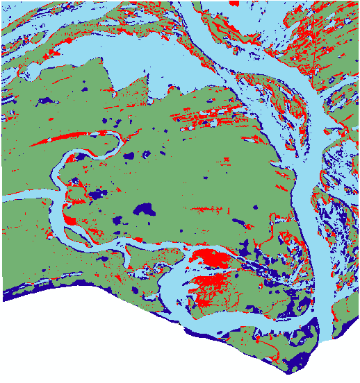
Refer to my image, dark blue refers to pixel mis-classify as water; while red refers to pixel mis-classify as land.
Those pixels at the right-hand side (or above) of flood water/ river water always “underestimated”, while at the left hand side (below) are “overestimated”. Is this give any hints? Any method can improve flood mapping?
There are numerous methods for image filter… how to select? What are the selection criteria?
I tried some, but… I don’t know how to justify? Trial and error?
No, both are optional.
The colours don’t matter, but rather the numbers of your classes. If the water is 0 and land is 1, and water is underestimated, try a maximum filter to increase those areas at the frame, for example.
Again, try to give the classifier more options where to put the pixels: Make several water classes in your training data set and several land pixels. This increases the chance that pixels will be at least in one of the correct ones.
yes, you can delete any band and save your product. I think so
công ty giup viec nha giá rẻ giúp việc nhà chuyên nghiệp
“try a maximum filter to increase those areas at the frame” you mean i can do the filtering at specific portion of image instead of whole image?
no, filters only work on the whole image.