How to obtain the azimuth looking angle in sentinel 1 images through SNAP?

Hello all,

Can someone clarify how to obtain the Azimuth angle from sentinel 1 images using SNAP?

I need the azimuth angle to find the relative wind direction. I’m’ following the instruction described in the study “Using Sentinel-1 SAR satellites to map wind speed variation across offshore wind farm clusters” by S F James.

The azimuth angle can be calculated from the corner coordinates of each image. These are found in the .manifest meta data file
that comes with each Sentinel-1 data file. The look direction is given by the bearing from the 1st to the 2nd or from the 4th to the 3rd corner coordinates.
Can someone point me out where to find the corner coordinates of the image in the .manifest meta file?

Hello,

you can find it in the footprint tag. In my file it is at line 219-221.

The related documentation is in the Sentinel-1 Product Specification in Table 6-7 page 93.

But you might want to look at these threads too:
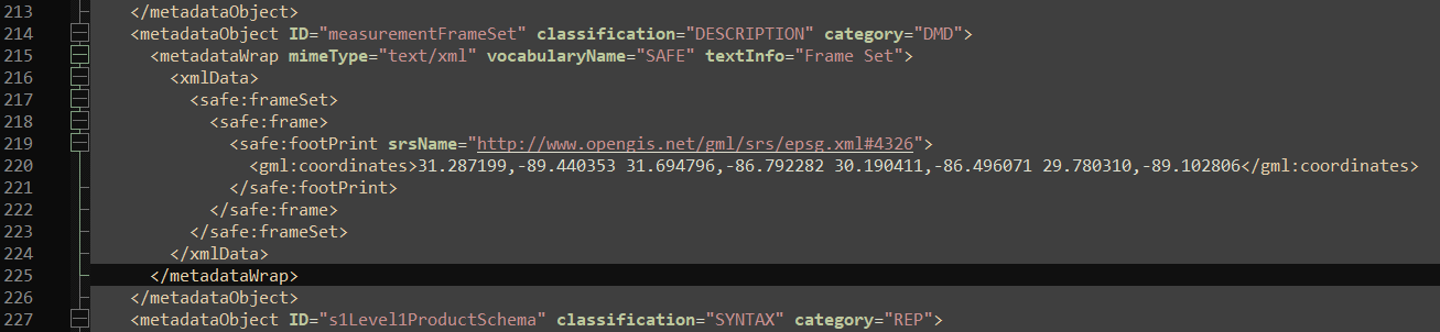
1 Like

You should be careful on how to derive the azimuth angle, for two reasons.

  • First, because the order of the points within the coordinates is not specified. It may change at any time (even if I am not aware of any change planned in near future on this domain).

  • Second, because what you are looking for is the direction of an azimuth line toward north within a product. This direction is varying within the product footprint. Below is an example of the planar angle between azimuth line and North on an EW product near the coast of Iceland. Red is around -8 degrees. Blue is -20 degrees. This is varying both in range and azimuth.

A proper way to compute this angle from level 1 product is to extract the geographic location of series of points within the image and then to compute the direction toward the north of points located in the same azimuth line.
This can be done inter alia by considering the positions of grid control points provided in the annotations of the products (their precision should be sufficient for this).

Furthermore, If you are interested in wind fields computed on Sentinel-1 imagery, you should probably have a look to the Level 2 / OCN products.
https://sentinel.esa.int/fr/web/sentinel/user-guides/sentinel-1-sar/product-types-processing-levels/level-2

Those products are available on the ESA data access hub (scihub, …).
They are composed of NetCDF file containing three types of measurement:

  • Radial Velocity
  • Swell estimation (only over WV and SM acquisition for the moment)
  • Wind measurement (all modes) including wind speed, direction, and the auxiliary information, including this heading angle, incidence angle, normalised radar cross section (nrcs) denoised or not, a priori wind speed and direction from ECMWF model, etc at 1km resolution

The complete wind inversion algorithm is described in this document:
https://sentinel.esa.int/fr/web/sentinel/user-guides/sentinel-1-sar/document-library/-/asset_publisher/1dO7RF5fJMbd/content/sentinel-1-ocean-wind-fields-owi-algorithm-definition

Those products are calibrated and monitored. Their performances are exposed in series of annual performance reports. For instance this one for 2022:
https://sentinel.esa.int/fr/web/sentinel/user-guides/sentinel-1-sar/document-library/-/asset_publisher/1dO7RF5fJMbd/content/sentinel-1-annual-performance-report-2022

As those OCN products contain series of gridded auxiliarry information, they contain all the information required for user to easily recompute wind speed with alternative algorithms if required.

PS: Bearing between two points can be found using pyproj
https://pyproj4.github.io/pyproj/stable/api/geod.html

2 Likes

If you are interested by wind speed measured at higher resolution and/or at other altitudes than 10m under neutral wind conditions, and/or wind ressource assessment, you may be interested by publications like the following ones:

de Montera, L., Berger, H., Husson, R., Appelghem, P., Guerlou, L., & Fragoso, M. (2022). High-resolution offshore wind resource assessment at turbine hub height with Sentinel-1 synthetic aperture radar (SAR) data and machine learning. Wind Energy Science , 7 (4), 1441-1453.

Cathelain, M., Husson, R., Berger, H., & Fragoso, M. (2023, April). Estimation of Wind Resource Assessment at High-Resolution Using SAR Observations, Validated with Lidar Measurements. In Offshore Technology Conference (p. D031S035R001). OTC.

2 Likes

Thank you for your help.Can you explain to me in more detail how did you get to the varying angles of -8 and -20 in that image?How would i compute the direction toward the north of the points in the same azimuth line?

Here is an implementation of computing the range look direction angle and adding it to an BEAM-DIMAP product as a new layer:
https://s1-nrb.readthedocs.io/en/latest/api.html#S1_NRB.snap.look_direction

2 Likes