So,
1.- All ifg should have little Bperp? It’s possible?
2.- Which are parameters for to define the master images?
3.- Is known, that the difference of adquisitions dates for each images give us spatial and temporal decorrelation, right!
4.- For PSI techniques is recommended VV polarization!
5.- Is recommended to make subsets, this should have same coordinates en lat-lon?
Hi, gabrielaquintana77
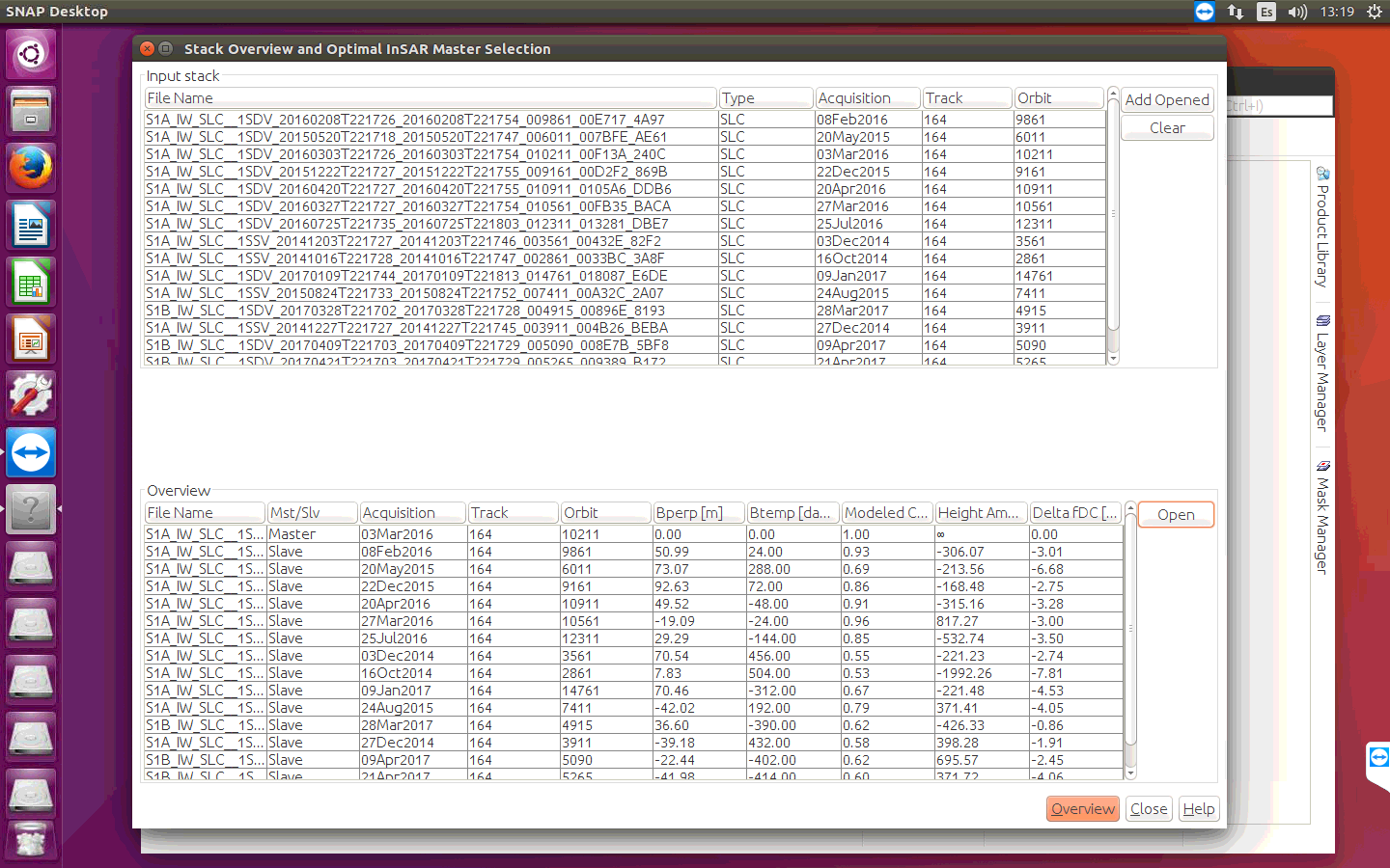
2 I take as the main (master) image the earliest by date
Only those images that are made from the same and the same position of the satellite in orbit for different dates are suitable.
4. To determine the displacements of the earth’s surface, polarization of HH and VV
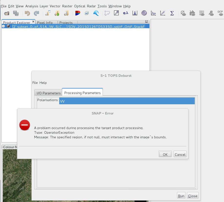
If we make TOPSAR Split (manually) + Apply Orbit (manually) + BackGeocoding for 15-20 Sentinel-1 SLC Images and after that make a subset from view using geocordinates, then applying Debrust for the subset could get this error. Does anybody faced this before or do you have any idea why this is happening.
You could think to do something like TopsSplit + AppOrb + Debrust each Image + BackGeo, but that will be boring and I am not sure or can not understand what is the difference if we make the Debrust before BackGeo and Ifg.
I’d like to ask your collaboration for checking out and review the steps I have collected to use PSI via SNAP and StaAMPS, would you please to find it as word attachment file. and many thanks in advance.
Hi @ABraun, @annamaria, @Katherine, @junlu
First of all, many thanks for share your steps in this forum… it has been very helpful for me.
I have process Sentinel, ERS and ENVISAT images in order to obtain PS points.
I have followed the methodology described by @Katherine and the one described by @annamaria. I have take cared of apply topo phase removal individually as mentioned @annamaria.
In the case of Sentinel I have run all the process (SNAP + StaMPS) without any errors and the results obtained are the ones expected (There are PS mainly over urban áreas).
The workflow followed for ERS and ENVISAT has been the next one:
1- Apply orbit file (DORIS for ENVISAT and DELFT for ERS)
2- Coregistration (master-slave pairs) (1=master+2, 1+3, 1+4,…)
3- Subset
4- TC (1+2, 1+3, 1+4, …)
5- Interferogram formation based in the output of 3-
6- Topo phase removal
7- TC
8- Add elevation band (Inf_1+2, Inf_1+3, Inf_1+4…)
9- StaMPS export of : Results of 4- and 8- . Note that this step has been carried on individually because exporting all the pairs in one stack, I have obtained NaN values in .base files. That is to say:
I first export
1+2 and Inf_1+2, then
1+3 and Inf_1+3, then
1+4 and Inf_1+4…
I will appreciate if any of you could help me please…
Hello AranLarra
Congratulations…
I assume that you have 10-15 Images and you coregister each (1= master + 2 and 1+3 and 1+4 ) then you create a stack of all (1+2 , 1+3, 1+4 …), therefore you have two file at the end to StaMPS Export.
I am not getting what do you mean by… “Note that this step has been carried on individually because exporting all the pairs in one stack, I have obtained NaN values in .base files”.
Dear All,
I have some comments and some questions which I have added in the file of falahfakhri. Can you please answer me and that would be a great help. Looking forward to your answers.
Thank you for your summary, the processing step that use PSI via SNAP is very clear. But I have two other questions. The first one is get StaMPS installed under Cygwin, I have tried installed it, although the installation is right and I can find the right path, the program occurred problems when it ran, but linux are good, have you ever tried run through the processing under Cygwin?
The second is about STACK AVERGING, I have never use this function before, and I don’t know if it is the right way to do so. Could you please explain it more detail?
The comments you have made in the doc, some are questions some are not, I’m gonna reply some of your questions, you can ask me later if you have further questions.
1.when you have several stack, just copy /diff0 and /rslc, and do not need to copy /geo and /dem
2.use master_dat.lon and master_dat.lat can have PS geocoded, TC is also OK(I have not tried this, but others have). You can find more detail in this topic and solve your problems about the file name and the others.
3.you should use mt_prep_gamma_snap(changed) provided by me, you can rename the file name or not, the usage of this script has also been discussed in this topic. If you works fine with ps_load_initial_gamma_snap.m provided by Katherine, then everything is OK, else you may use the file ps_load_initial_gamma_snap(changed).m provided by me, In any case, you should rename the file to ps_load_initial_gamma.m and replace the original one.
4.the installation of StaMPS you should check the software manual, and if you only use StaMPS and SNAP to process S1 data, you do not need to install Doris and ROI_PAC.
Thanks for your answer.
I did not get any clue about TopsSplit and interestingly you did not applied Debrust
What I am getting from your answer is,
You have 25 Images, then you did 24 times [ 1- apply orbit, 2- Coregistration (master-slave pairs) (1=master+2, 1+3, 1+4,…) and 4- TC (1+2, 1+3, 1+4, …)] and also you did 24 times [5- Interferogram formation based in the output of 3, then 6- Topo phase removal, 7- TC and 8- Add elevation band 24 times (Inf_1+2, Inf_1+3, Inf_1+4…)]
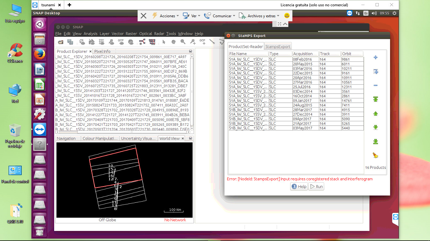
That means, you did 24 times [StaMPS export of : Results of 4- and 8-] but in SNAP you can not do StaMPS export using only one single pair.
I would be really glad to you. If you write down your process in more detail and that would be a real help. I really congratulate you as you have the best result so far.
Your answers are great help at this stage. I have a specific question on point 2. In my case I have done TC and then I have lat and lon file in my Ifg. I exported it into gamma format and then I rename as master.lat.rslc (rslc is the file format) and master.lon then copy/paste into /geo folder. I am not getting if the file format is .lon and .lat ?? Can you please explain a bit more how you have generated this lat and lon files.


 That is to say: