I have not did it yet
I use radar >> coregistration >> coregistration steps, is this wrong?
and which one should be master or slave?
l’ve finished with coregistration and was succesful, ^^
and what next to fuse them? is it possible to use brovey, pca, hsv transformation?
did [quote=“dini_ramanda, post:22, topic:6277”]
l’ve finished with coregistration and was succesful, ^^
[/quote]
What did you change so that it works now?
Visually, you can display an RGB or HSV image of both inputs. Technically, a PCA would be the first I could think of in SNAP. As S2 has more bands than S1 it will be dominant in the PCA but the S1 should still be included in the main components. You could also calculate further S1 products of the S1 image (right-click > create filtered band, eg. sobel filter or high pas filter) and have them in included in the stack.#
I would be interested in screenshots.
i just follow your instruction to use coregistration - stack tools - create stack
emmm sorry, i dont understand, maybe you can give specific of the step, i little confused what you mean
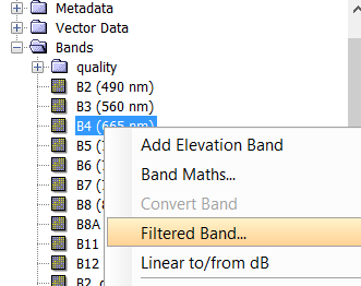
cause there is no create filtered band when i do right click on the image
ah, okay. That’s just stacking, not coregistration. But if the result is good, everything is fine.
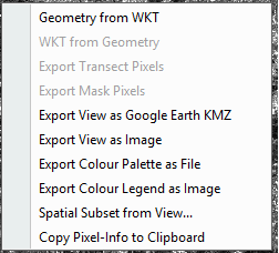
If you right-click on the S1 bands in the stacked product you can derive some filters (edge detectors, standard variation ect. ) with “Filtered band”
It is written in your product as a virtual raster. If you want to permanently save it, right-click and select “convert band”, then save your product with File > Save Product. These measures can then be used in the later PCA as well and might compensate the uneven distribution of bands of S2 and S1.
IMO one should terrain correct the SAR images and reproject the optical images into the map projection of choice, and then perform stacking. Co-registration between SAR and optical cannot work very well since the geometry of the images is not the same (even though it is similar if the the area of interest is relatively flat).
I actually thought Terrain Correction was already done.
@dini_ramanda: Please have a look at these steps of preprocesing:
@ABraun what different between the steps that i have done (calibrate, spekle filtering, range dopler terrain correction) and that specific step for the result of S1 data? is it make S1 image better or else?
if you performed calibration and RD terrain correction everything is fine. The first is radiometric correction, the second geometric correction. All other steps are more or less optional.
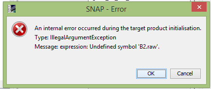
when i want to do PCA, there is an error, help me @ABraun
I don’t know where this band could come from. You can try saving the product in another file and run the PCA again.
B2.raw is apparently used in some expression. The ‘.raw’ refers to the raw unscaled value of B2. It seems you don’t have a B2 band but somewhere it is expected. But I can’t say why.
@ABraun it doesn’t work, so what must i do now? its stuck
@marpet hmmm okay, thanks for your answer marco, Do you have another solution?
anyway, is it possible if i want to build DSM using S1 SLC product?
Did you apply sen2cor on your Sentinel-2 product? Maybe this caused the ‘.raw’ file.
technically, no. Interferometry always requires two products. But also with an image pair you won’t get a proper DSM out of S1 because c-band is too sensitive towards changes over vegetation, for example. It worked in some cases, as you can see here:
no, i did not apply it, so… is it possible to fuse dem from S1 with S2 data?
It seems the bands are renamed but the valid expressions are of the bands are not.
Right-click on the band, choose Properties and remove the valid expression.
Hello,
I want to coregister Sentinel-1A imagery and Sentinel-2A imagery. i have taken subsets of both the images.
On Sentinel-1A, I have performed calibrtaion, multilooking, speckle correction and terrain correction.
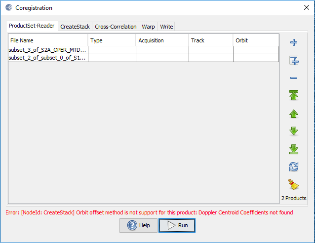
When I am trying to coregister both the images, following error is being shown:
Error [NodeId: Create Stack] Orbit offset method is not support for this product. Doppler Centroid coefficients not found.
Please help.
This is the initial offset selection in the CreateStack. There isn’t orbit information in the Sentinel-2 product so you’ll need to use Geolocation.
Follow the advice above by @mengdahl and terrain correct the SAR and use the same map projection with the optical then just use CreateStack with Geolocation for the initial offset and bilinear resampling.
2 Likes
Abraun sir
After the collocation process what should be done to fuse the images.