Dear all
I saw below paragraph (page A-16) in ´InSAR Principles: Guidelines for SAR Interferometry Processing and Interpretation´tutorial but I think the picture is not appear. Do you have its picture or know how can I get it?
I think in this toutorial we have two pages for A-13 (it should be a kind of mistake….)
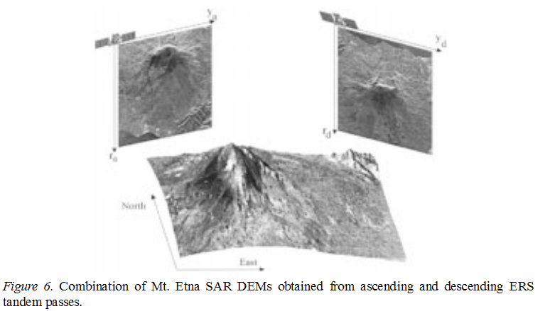
Here two detected ERS images of Mount Etna (Italy) taken from ascending
and descending passes are shown together with an elevation model of the
imaged area. A comparison of these two images clearly shows the effect of
the different perspective: the summit is shifted away from the coastline in
the ascending (left) ERS SAR image and towards it in the descending (right)
image. From these images it is also evident that high resolution details of the
western flank of the volcano are obtained from ERS ascending passes,
whereas the eastern flank is ‘squeezed’ into a few pixels of the SAR image;
the opposite happens with descending ERS passes. Thus, both ascending and
descending passes should be exploited to get a high resolution SAR image of
the whole area. It is necessary, however, to resample both images on a
common reference grid in order to be able to make such a combination.
Hi =) !
Did u get any idea since the time you ve written this post about how to solve this problem and where to find this image?
many thanks
Hi my friend…no I do not find pictures…
I think the image was originally taken from this publication:
Rocca et al. (2000) Sar Interferometry And Its Applications
http://link.springer.com/content/pdf/10.1023/a:1006710731155.pdf (don’t know if this link works to unregistered users)
This could be the image which is meant:
Thanks. I should go through this paper.
Hi dear !
ok thanks anyway, i think you have seen it we got very very lucky because another friend found it =) =)
Thanks a lot ! now i have a better anderstanding regarding what it was meant in those lines
if you ve read that document, it is split in 3 part: A, B, and C. I m reading the B part and i found it much more difficult to understand than the first one that was very clear. I think it s because my limitated knowledge in attive RS… so fingers crossed and lets hope to understand more in the next days =) =) !!
the only challenge that I will lose, it will be the one that I will not take! have a nice day guys and thanks both again =)
Acknowledgment to the team who created this guide, yet I still can’t quite understand the equations in Part 1, section 2 “SAR interferometry: applications and
limits”. For example, in page A18, 2.2 Terrain altitude measurement through the interferometric phase, the term qs which is “The displacement between the resolution cells along the perpendicular tothe slant range” is quite vague; also how are equations 2.1, 2.2 derived.