I need your suggestions. I’m studying about of landslide deformation on SNAP. I’m using Sentinel1A-SLC images. The study area is a village with active landslide.
I downloaded 11 data from the study area. According to baseline and temporal values, I created image pairs. (15 image pairs) Because I want to generate time series (interferogram series )to observe the landslide deformation. After then, I created interferograms. According to the following steps,
S1 TOPS Coregistration,
Interferogram Formation,
Debursting,
Topographic Phase Removal,
Phase Filtering and
Multilooking.
And then, I examined all of the interferograms that formed. But I can’t see any fringe in the landslide area.
However, there have been landslides since 2011 in the landslide area. And also nowadays landslide activity is continuing. I have to detect the deformation in that area with InSAR technique.
Are there any mistakes in my steps? What can I do else? Would you share your suggestions please?
I would be glad if you help. Thanking you in advance.
Did you investigate the coherence for your interferograms?
Depending on the direction of landslide, your coherence might just have gotten lost. And without coherence chances on proper fringes are quite low.
coherence is computed in the interferogram generation step. It should appear as coherence raster band in your product, next to Intensity and Phase bands.
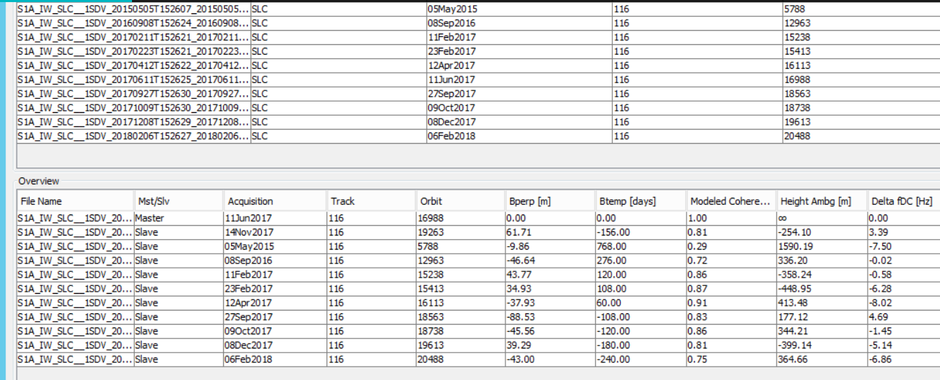
Thank you Andreas, Yes, I checked the coherence values. I thought it was normal values. I’ve added the table below.
Besides, landslide is not in the form of a rupture. So there is no mass movement. There are slip in houses and agricultural land. So, I would like to consult you. Can I try another method with the same data(Sentinel1A_SLC) on SNAP? For example, PSInSAR. If it possible, how can I do it?
I’m waiting for the suggestions of all related friends and you. Thanking you in advance. =)
the values you show in the tables are not the actual coherence, only the one that could mathematically be expected based on temporal and perpendicular baselines. According to changes in surface scattering, they can be considerably lower.
PSI is a powerful method but certainly harder to understand and apply.
@semra I suggest you to make unwrapping procedure & then try to find the displacements.PSI is nice but needs highly coherent points such as open areas with no vegetation where high coherence could be expected. In the tables you put there the values are labelled “modeled coherence”. I guess ABraun was asking for the real coherence values from the IF pairs you made. If your area has a lot of vegetation or is hilly PSI is nice to explore.