I’m hoping someone here has some information for me.
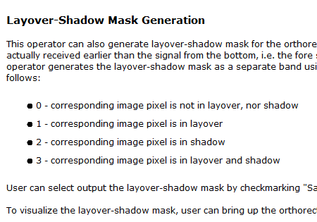
The SNAP help information has the following information on possible values in the Layover-Shadow mask generated in SAR Simulation:
However, when the mask is generated, pixel values are not only 0, 1, 2, or 3-- in fact, they range up to 13. Can anyone tell me what pixels should actually be understood as those in layover-shadow? If I take the area for my study region in layover-shadow based on the above pixel value designation, the area is about 700 square kilometers. But, if I take any pixel != 0 in the layover-shadow mask to mean it is in layover and/or shadow, the area is about 1800 square kilometers-- a significant difference.
I have this same issue when generating the layover and shadow mask. Pixel values range up to 9 for one and even 15 for another image.
Has anyone of you been able to find the source and solve this?
sounds to me like this is rather a bit mask, i.e. 0-3 refer to the bit positions and the result contains bit-combinationed values (and, in contrast to what the explanation seems to indicate, multiple of these categories are set to true). just a guess based on the value range observed…
Hi all. Is there an update on this? The values in the mask prior to Terrain-Correction are fine. So I guess it is a problem of interpolation as @mengdahl pointed out. Although I believe nearest neighbour would not be the best choice for discrete classes. I would prefer mode resampling.
It would be great if one could provide multiple interpolation modes to Terrain-Correction. Not just one for images and one for the DEM, but different ones for individual bands. Something like this: