yes, I do want to use WMS-Service. Could you help me?
Probably the data you are using is not geo-referenced.
What kind of data are you using?
SAR data and the corresponding optical data, for example, Google map, Baidu map, et… Do you think it is suitable?
I don’t know how you can use Google map or Baidu map. If they provide a WMS it might work.
Is the boundary of your SAR data shown in the World View. Or do you see lat/lon coordinates in the status bar at the bottom of SNAP?
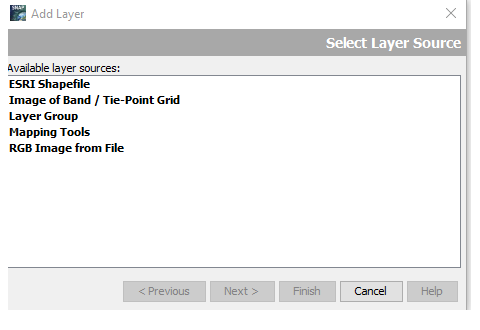
Yes, the SAR data I am using show the boundary and the lat/lon coordinates are shown in the status bar at the bottom of SNAP, but there are no “Image from Web Map Server (WMS)” option. I’m confusing about it, please help me.
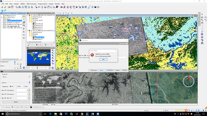
I want to upload online map using the software SNAP as you said “add layer” option, I input the map link, but there appears errors. I don’t know how to solve this problem.
It seems that SNAP can’t process the answer from the server.
Maybe you get an indication why it fails if you first reproduce the error and then go to the menu (Help / Show Log Directory) and open the messages.log file in a text editor. And the end you might see a more exhaustive error message.
Can you post the URL you are using?
Thank you for your reply. But I can’t find the menu (Help / Show Log Directory) .
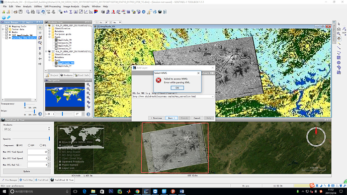
I input the WMS url: http://www.skylab-mobilesystems.com/en/wms_serverlist.html, according to https://seadas.gsfc.nasa.gov/help/visat/LayerManagerWindow.html. But it didn’t work either. I don’t know why. Looking forward to your early reply, thank you so much again .
Now I see that you are still using a very old version.
Please download the latest version we provide here.
The second problem is that you can’t enter the HTML web page here. This web page simply lists possible web mapping server. But it seems that the list is outdated and most of the entries don’t work any more.
The following pages list available server.
WMS servers for use
Finding OGC WMS, WFS, WCS services
Not all do work too.
It’s not easy to find good WMS.
Dear Marco,
Thank you for your reply.
But the URL you provided cannot be used either and the screeshot is in the attached file. I still couldn’t get the answer.
Looking forward to your early reply.
Sincerely,
Juanping
----- 原始邮件 -----
发件人: “Marco Peters” forum@step-email.net
收件人: juanpingzhao@sjtu.edu.cn
发送时间: 星期二, 2017年 2 月 14日 下午 3:52:34
主题: [step] [snap] Load online map
Now I see that you are still using a very old version.
Please download the latest version we provide here.
The second problem is that you can’t enter the HTML web page here. This web page simply lists possible web mapping server. But it seems that the list is outdated and most of the entries don’t work any more.
This (http://129.206.228.72/cached/osm?Request=GetCapabilities) is a link to a server which you can use.
These pages also list available server.
WMS servers for use
Finding OGC WMS, WFS, WCS services
Not all do work too.
It seems that some of the problems we have with the WMS are related to an old library (GeoTools) we use.
I’m currently updating our software to the latest version. So the behaviour in the next release is probably better.
Okay, thank you very much~
But what time could a new version be used by users?
I want to add web maps, such as bingmap, baidumap, etc. as a separate image layer to help SAR image understanding by using the new SNAP version.
Looking forward to your early reply and the new products.
Thank you again.
Juanping
----- 原始邮件 -----
发件人: “Marco Peters” forum@step-email.net
收件人: juanpingzhao@sjtu.edu.cn
发送时间: 星期一, 2017年 2 月 20日 下午 4:16:03
主题: [step] [snap] Load online map
It seems that some of the problems we have with the WMS are related to an old library (GeoTools) we use.
I’m currently updating our software to the latest version. So the behaviour in the next release is probably better.
Hi marpet,
I want to add this WMS service: http://idena.navarra.es/ogc/wms
The server web is https://idena.navarra.es/Portal/Servicios
How I can do it?
Thank you
MIKEL
I think the service is not working. Because in the responds it says “java.lang.NullPointerException null”.
So you can’t add.
If it would work properly you can do it as I have written earlier:
<?xml version="1.0" encoding="UTF-8"?>
<ows:ExceptionReport xsi:schemaLocation="http://www.opengis.net/ows http://idena.navarra.es/schemas/ows/1.0.0/owsExceptionReport.xsd" version="1.0.0" xmlns:xsi="http://www.w3.org/2001/XMLSchema-instance" xmlns:ows="http://www.opengis.net/ows">
<ows:Exception exceptionCode="NoApplicableCode">
<ows:ExceptionText>java.lang.NullPointerException null</ows:ExceptionText>
</ows:Exception>
</ows:ExceptionReport>Ok,
So the problem is the server’s URL no my SNAP.
Thank you
MIKEL
Hi marpet,
I am trying to load some WMS service but I cannot do it because the finish button is not on.
Can you provide any URL to check if i can load WMS services?
Other question is that only one of the three WMS URL provided by SNAP works well, I obtain a error with the other two.
Thank you,
MIKEL
Yes, meanwhile the URLs are outdated. We should remove them (SNAP-715).
This URL should work:
http://demo.cubewerx.com/demo/cubeserv/cubeserv.cgi
Before clicking on Finish you need to click on the Next button to get to the next step. At this step you select the content for the layer. And then you can also click on Finish.
Hi marpet,
my version of SNAP (8.0) doesn’t have this option to add Image from Web Map Server. Is there a way to activate it?

This option is only shown if your current scene is compatible.
It needs to be reprojected to a CRS.
For Sentinel-2 MSI data this works by right away. While e.g. Sentinel-3 OLCI needs to be reprojected first.

