I am a Masters student and my research is based on mapping the tree height and biomass of mangroves using sentinel 1 (RADAR).
I am facing challenges in getting the real methodology on mapping the tree height and articles are so scarce on that matter especially on Radar data.
Can you kindly assist?
Let’s start with your second demand, which is
It is possible to calculate the Radar Vegetation Index, RVI, this topic is quite discussed in here, and how could be modified the equation,
Also you could take a look at
Agricultural Applications with SAR Data
Also it is possible to classify S-1 images (GRD)
LAND COVER MAPPING USING SENTINEL-1 SAR DATA
DEFORESTATION MONITORING WITH SENTINEL-1 Case Study: Paraguay, 2018
Let’s comeback now to your first demand
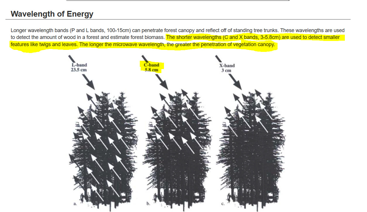
It is not possible to measure the tree heights using S-1 for a very simple reason that S-1 is C-band 5.8 cm wavelength
2 Likes
@falahfakhri thank you for your import. so what can i do now to measure the tree height
in my opinion, this is a quite ambitious topic for a master thesis, especially if there is no experience in this area.
The problem is that Sentinel-1 signals decorrelate over vegetation quite quickly. Therefore, interferometric measurements of vegetation are hardly possible. I don’t think this can be done in SNAP, because the standard tools (classic interferometry) don’t allow this kind of analysis.
You could have a look at the PolSARpro toolbox which was designed for biomass analyses. But I don’t know if dual polarization data (Sentinel-1 has only VV+VH) can be used for forest height inversion.
https://www.ietr.fr/polsarpro-bio/
At least there are examples within the program on this topic.
2 Likes
I think you could try up airborne LIDARSACAN or Laser scan, this is explained in here, of course in case you have this capabilities,
ACCURACY OF MEASURING TREE HEIGHT USING AIRBORNE LIDAR AND …
The other scenario you could use ALOS PALSAR, L band,
1 Like
you might also want to have a look at the ESA Polarimetry Course materials (January 2019), especially on the tutorials on forest height inversion:
3 Likes
thank you so much
Dear MissGee,
I am writing my doctor thesis about this topic and I dont think it is feasable in the context of a master thesis. Especially S-1 data is not useable for this aproach since the temporal baseline between two timesteps (you need for creating an interferogram) is too long. The temoporal decorrelation over forest/trees or mangroves is just too bad. You can use a coherence optimization approach to get a better coherence but in my example areas the results were still too bad to calculate tree hight. I tried it with SNAP, PolSARpro and also ERDAS Radar Toolbox. As @ABraun was mentioning the dual-pol data of S-1 is also an issue in PolSARpro.
If you are still interested in doing this topic have a look in random volume over ground or random motion over ground models.
All the best
4 Likes
thank you so much for your assistance. can i work with getting canopy height and then subtract DEM to get tree height in this case?
Yes, this would be the overall plan, first getting the canopy height from the inversion models (for example random volume over ground) and than subtracting a DEM.
1 Like
@MissGee Hi, I was just wondering have you been able to extract tree heights fro the Sentinel data? I know that it has been a long time but I am working on a similar problem and would be grateful if you could provide some insights. Thanks.
I would suggest exploring the Global Ecosystem Dynamics Investigation Lidar (GEDI Lidar/laser altimeter) which precisely measure forest canopy height, canopy vertical structure, and surface elevation.
1 Like
Thank you very much for the reply. I will check it out.