It might be some how off-topic, but just to spread the word in this forum.
*MASADA stands for Massive Spatial Automatic Data Analytics. It has been developed in the frame of the “Global Human Settlement Layer” (GHSL) project of the European Commission’s Joint Research Centre, with the overall objective to support the production of settlement layers, by automatic classification of high and very high resolution satellite imagery. The tool builds on the Symbolic Machine Learning (SML) classifier; a supervised classification method of remotely sensed data which allows extracting built-up information using a coarse resolution settlement map or a land cover information for learning the classifier. The first version of MASADA (v1.3) supports Very High Resolution satellite data and includes pre-defined workflows for a variety of sensors (e.g. SPOT-5, SPOT-6/7, RapidEye, CBERS-4). The second version of MASADA (v2.0) is tailored to the processing of Copernicus Sentinel-1 and Sentinel-2 data. … *
thank you for the information!
Is MASADA v2 available for download yet?
@ABraun In the user guide it is said that one can download it.
Did you find it already? According to this site, it is not released yet: https://ghsl.jrc.ec.europa.eu/tools.php
It is worth try this one - https://ghsl.jrc.ec.europa.eu/documents/MASADA_1.3.zip
On the same page you provided I found this
yes, I just wanted to know if I somehow overlooked that version 2 is already available somewhere. I only see v1.3
@ABraun I just wanted to inform the community here about this tool that make use of S1 data. I suppose it can be used as benchmark for settlements extraction from S1 data.
I hope soon the v2 will be made downloadable.
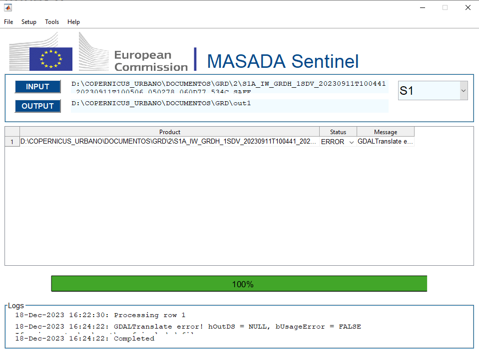
Hello everyone, I know its been a while since this publication but i would like to know if theres any user that has been working with this tool. I understand that it is descontinuate but im trying to replicate the workflow of the HRL Imperviousness (https://land.copernicus.eu/en/technical-library/hrl-imperviousness-2018-user-manual/@@download/file pp.32) and I need to compute the intermediate layers using MASADA. I had no issue with the calculation of Sentinel-2 products, however with the products of Sentinel-1 im getting this following error: Error using gdal_translate_binmex
GDALTranslate error! hOutDS = NULL, bUsageError = FALSE
If using vrt check paths of included files
Im using the GHS 2023 10m resolution. And the preprocessing for sentinel-1: Apply Orbit File > Thermal Noise Removal > Calibration > Terrain Correction > Write .
It would help if any of you have some experience working with this tool.