Good day,
I´ve been trying to create a timeseries of VV and VH images for an entire country, in the case Portugal, for one year, in descending orbit, by which I´m applying this method using snap command line gpt with the goal of crop mapping:
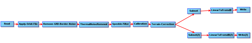
1 – preprocessing
2 – Mosaicing

3 – Using python I clipped the mosaic and generate the intended images for that date (2 consecutive dates to be able to encompass the whole country), also converting to GeoTiff.
Now, it seems I always stumble in the same problem: misalignemnt of pixels between images.
As mentioned by @glemoine I set the “align to grid” to true (which worked fine in other images), hoping it would help, even though the images are meant to cover the country not to overlap completely (maybe it won´t be helpful in this case in any way) but in the end of the process the pixels are not alligned. The solution for this is to stack and then to unstack? Only this is very memory and time consuming. Is there any other way I can solve this issue without using stack?
Is this what you would do for crop mapping purposes a in large scale area?
Maybe it´s better to make convertion to DB later on as I still have to do the mosaicing?
Any help would be very, very much appreciated.
Thanks.