As a little detour from my Sentinel 1 data work, I’ve also picked up some MODIS work, I noticed that SNAP can open these files and handily save them as GeoTIFFs, I was wondering whether SNAP had any functionality to mosaic MODIS data? I tried to mosaic two files using the Raster > Geometric Operations > Mosaic functions but received:
This is probably more down to my lack of knowledge about this dataset, could anyone refer me to a good place to look? If SNAP can do this it would be great as it’s now part of my development pipeline.
I get the same error with other OCSSW processed MODIS Aqua level-2 files. The files load in the GUI, but not Mosaic. I tried using pconvert to produce a BEAM DIMAP. The DIMAP file also loads in the GUI, but fails in Mosaic with the same error, see snap_messages.log (87.2 KB)
Mosaic in NASA SeaDAS 7 does work with the OCSSW generated level-2 files.
Mmh, either we miss an update in our seadas reader or we need to make the mosaic more robust.
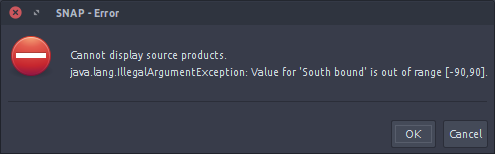
However, it seem that these products return latitude values higher than 90 or lower than -90.
Also possible that the SeaDAS guys adapted the mosaic. Actually they use the same mosaic implementation.
We will check this.
A colleague just showed me a failure whie trying to subset a NASA VIIRS global level-3 SMI. In his case, the log said the longitude was outside (-180,180), so it not only latitude causing problems.
My colleague needs to a time-series of level-3 mapped data for specific ROI’s. The subset operator works for NASA level-3 mapped NetCDF files when using import+generic+NetCDF-CF, so is actually simpler than my colleague’s inital method that required loading the complete files and creating new bands with subset. Hopefully the same approach can allow Mosaic to be used with the NASA files.