Hello everyone,
Please have a small problem with NDVI calculated from a sentinel-2 image. I did the correction using Sen2cor in SNAP.
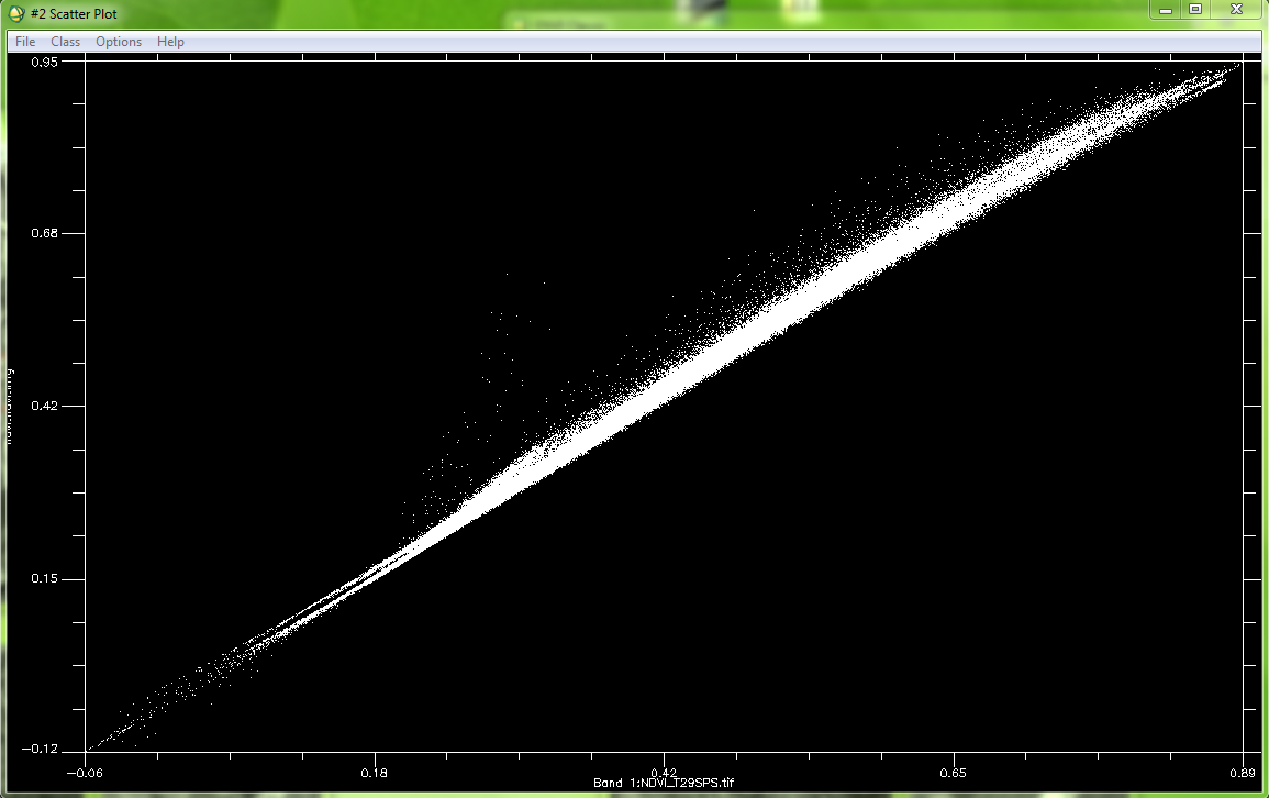
I calculated NDVI with bands 4 and 8 (band 4 for red, and band 8 for PIR), after I compared this result with NDVI calculated by the SCP plugin of QGIS, but I found that This comparison is not good, in my opinion I should have some adjustment between the two NDVI ?
– in Band X : NDVI calculated by QGIS
– in Band Y : NDVI calculated by SNAP
Do you have any idea about this topic ???
Thank you in advance .
Hi,
it seems one is corrected from atmospheric effects (SNAP SEN2COR) , and I guess one isn’t (QGIS SCP, I do not know that one well).
Atmospheric correction usually tends to increase the NDVI, which is what is observed in the scatter plot.
If QGIS SCP also does an atmospheric correction, then, I don’t know…
Regards,
Olivier
2 Likes
Hi Olivier,
Thank you for your reply, yes QGIS SCP also does the atmospheric correction, it uses DOS1, but the problem is with the correction by Sen2cor, above all is well with version 2.2 of Sen2cor and SNAP 4. but with the new version of sen2cor (3) and SNAP, I have this problem.
Regards,
Jaouad
Hi! I would like to know if you have done the atmospheric correction for the whole Sentinel-2 image or have you done it using the Tiles?
Hi, yes have done the atmospheric correction for the Tiles?
But I do not think it has an effect on the atmospheric correction of the image.
Thank you. I am downloading Sentinel-2 images from Amazon Web Services (the images in TILE format are about 130KB and not 6GB as the SAFE format) and I would like to know if there is a way of doing the atmospheric correction using QGIS SCP for the TILE image.
Yes you can upload your image and make the atmospheric correction simply in SCP with QGIS
You can find more information in this link https://fromgistors.blogspot.com/p/semi-automatic-classification-plugin.html
1 Like
Well Dark Object Subtraction is a very basic method, and not very accurate, as it does not account for the atmospheric transmission, which is reduced in presence of aerosols. Sen2cor should perform better, especially if your image is a green one.
But I can’t tell you more, I am not an expert of both softwares, I have my own one : http://www.cesbio.ups-tlse.fr/multitemp/?p=6203
Hi Olivier Hagolle,
Yes you are right, sen2cor is more performe than DOS.
But about MACCS I think it is not available to everyone.