Thats the same as I have,
can you open it with File > Import > Optical Sensors > Landsat > Landsat 8 30m > Select MTL file ?
I want to run the thematic land processor on it, but can’t
Use the *T1.xml, you can drag it directly from you file explorer into the Product Explorer
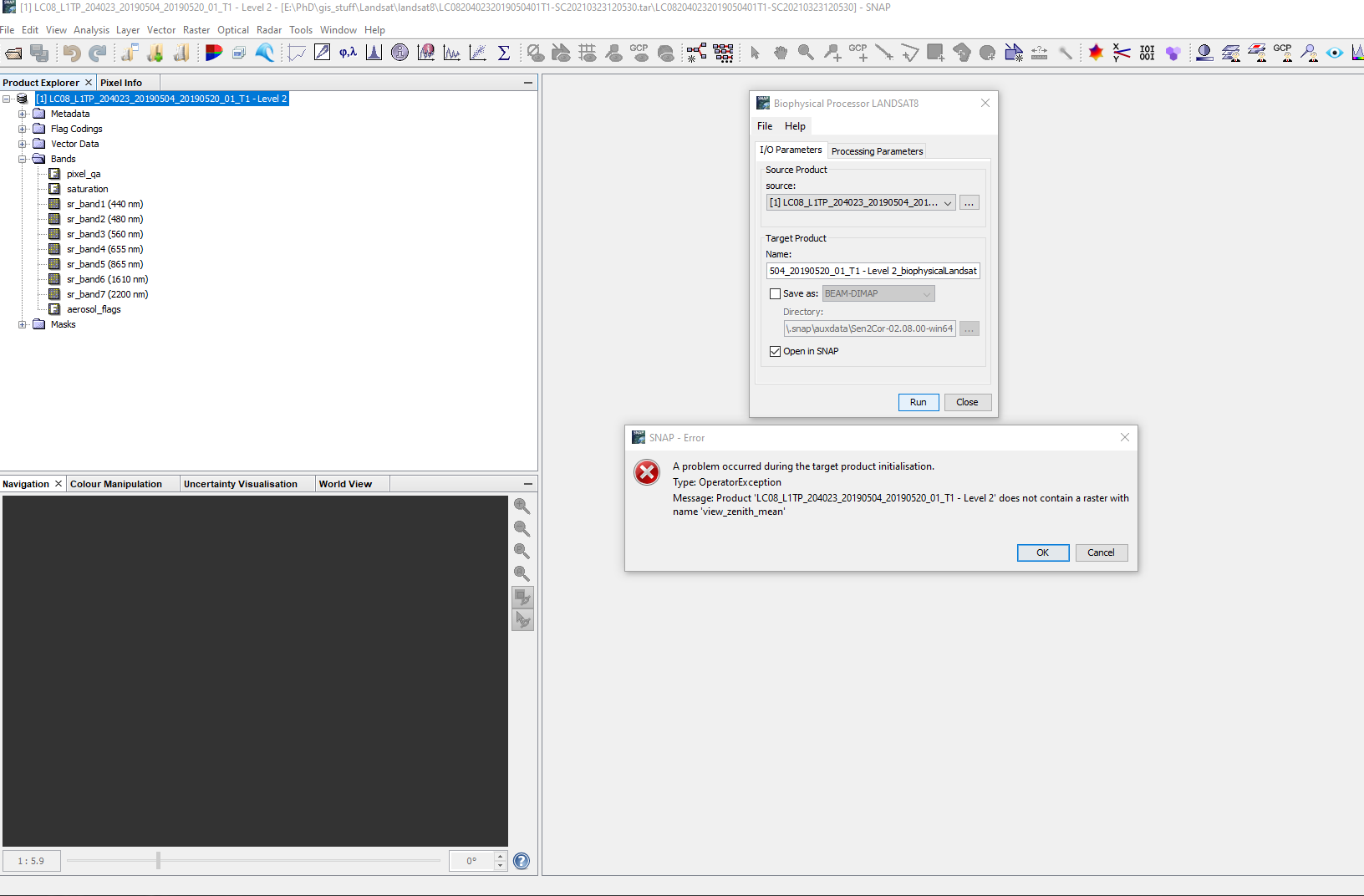
And when i try and run the thematic processor i get:
people keep insisting that i can calculate LAI from Landsat, but i cannot find any way to do it!
Have you checked here?
1 Like
Please could you tell me how? as you can see from this thread it is proving difficult.
Thankyou
@abruescas I have been told on this thread that using collection two is noy possible at the moment, hence me using collection one, buit i seem to be downlaoding different file collections to @ABraun.
The information you linked to seems to refer to collection 2

sorry for my late response, but I didn’t have any Collection 1 Level 2 product available, so I had to order one and wait for the download.
This is what works for me
Product ID: LC081940262021022801T1-SC20210324183935
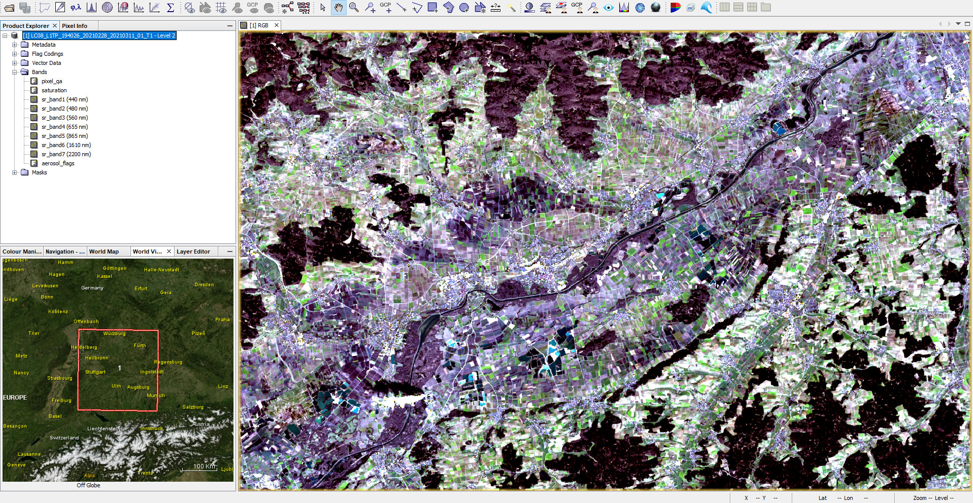
File > Import > Optical Sensors > Landsat > Landsat 8 30m
Select the tar.gz file instead of any extracted data.
Gives me correctly loaded bands including metadata on bandwidths ect.
There is a website which provides a database for such index algorithms.
Here are those for landsat 8:
IDB - Sensor: Landsat 8 (indexdatabase.de)
You find the NDVI and also a specific LAI.
You can even use the L1 TOA data. Results will be better when doing an AC before, e.g. with iCor. I see those index algorithm only as good guesses, in most cases.
I have also found an equation which converts NDVI to LAI: LAI = 0.57exp(2.33NDVI)
1 Like
The problem is that to calculate the LAI the sun zenith angle is required and this band is not in the Collection 1 L2. I have not tried yet the GPF graphs with Collection 2, I am not sure if they work properly. I will try later.
oh, I see…
Thanks all
@ABraun, thankyou , that method works, i was trying to open the umpacked files, importing the tar.gz works perfectly.
@marpet, i’ll look intoi the indexes you referenced, btw, the researchgate thread you linked to also has this equation for Landsat 8 LAI:
For landsat 8 , LAI index is calculated in a two step process: 1. calculate SAVI 2. use it to calculate LAI.
SAVI= 1.1*(b4 - b3) / 0.1+(b4 - b3)
LAI= - ln[(0.69-SAVI)/0.59] / 0.91
@abruescas your comment about the zenith angle answers my question! please let me know if you have any success with the gpf grqaphs, and maybe you could share your method.
As a general question to all, and please remember I’m new to SNAP,: Is there a way of automating this process? - I open an image(i.e. Landsat collection 1 Level 2), subset to get my ROI, resample to give the new file the same pixel size as my Sentinel subsets, calculate the NDVI and savbe the final product so i can use it with my python scripts.
I am imagining something like an excel macro which can be run on each individual product by recording the steps taken for the process?
Many Thanks
Matt
yes, you can use the Graph Builder to design a chain of operators, predefine their parameters and save it as an xml. Then you apply this XML to a list of files in the Batch Processing tool.

AH, excellent, Thankyou @ABraun
Landsat files from EarthExplorer are .tar files, not .tar.gz.
File > Import > Optical Sensors > Landsat > Landsat 8 30m does not work on the ,tar file.
I tried to compress it into a .gz file and could not open it either.
In all cases I obtained the same message "no appropriate product reader found.
Using SNAP8 on a MacOS.
Not all collections are supported in SNAP, please see above.
My mistake. Collection 1 works fine.
The USGS has this warning:
Landsat Collection 1-based forward processing will remain in effect through December 31, 2021. Starting January 1, 2022, all new Landsat acquisitions will be processed into the Collection 2 inventory structure only. For more information, visit the Landsat Collections website. https://www.usgs.gov/core-science-systems/nli/landsat/landsat-collections
hi i need your help in somthing if you are avilable
i want to calulate spm suspended matter on snap using landsat 8 IMAGES
CAN YOU HELP ME PLZ
SPM can be computed in SNAP with the C2RCC processor. It also provides IOPs and other information.
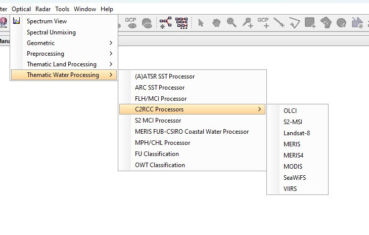
Background information on the C2RCC processing can be found at:
C2RCC – The C2RCC Community web page.
1 Like