I’m trying to confirm the pixel size of S1 products after terrain correction (using WGS84 defaults etc.).
I’ve processed two images - one nearish to the equator and one in northern Russia - at latitudes 16.45944 and 72.75389 respectively.
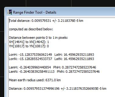
If I use the Range Finder measuring tool to measure the distance across a pixel on the one at 16 deg latitude, the distance is near enough 10 m.
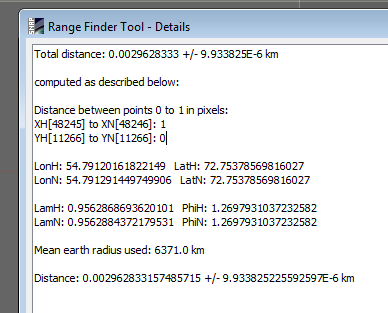
If I do the same at 72 deg latitude, the distance is around 3 m.
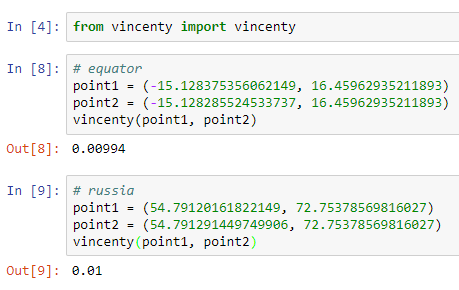
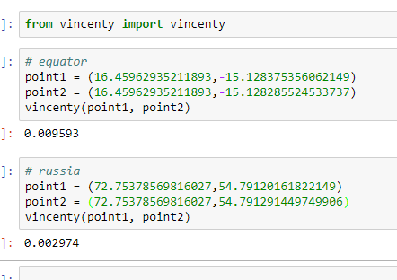
If I calculate the vincenty distance between each side of pixel using the coordinates LonH/LatH and LonN/LatN from the screenshots above at the two extremes of latitude, both are 10m.
I’m currently hoping that the pixel size of an S1 product IS 10 metres square and equal to the same area of ground regardless of where the image is - can anyone confirm either way?
I think this can be, because the number of pixels along a row stays the same but the circumference at higher latitudes is less than the circumference at the equator. See the image on the right of the Wikipedia article.
Sentinel-1 IW GRDH products have a pixel size of 10m in the range and azimuth directions, anywhere on the planet.
When you terrain correct an image, the output image is no longer in range by azimuth and the pixel size may be different. In S1TBX’s RD Terrain Correction operator you can specify the pixel size (in meters or degrees) of the output image.
In your case it’s probably an issue with the precedence of the ‘pixel size (m)’ and ‘pixel size (deg)’ parameters in SNAP GUI RD TC operator. Both pairs of points are separated by 8.98e-5 deg of longitude, which corresponds to 10m at the equator but to shorter distances at other latitudes. If you delete the value in ‘pixel size (deg)’ I believe SNAP will simply use whichever value is in ‘pixel size (m)’.