Hello.
I’m trying to figure out the difference between L2A products downloaded from Planetary Computer service vs SentinelHub service.
What I do:
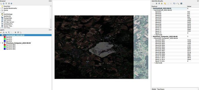
I’m trying to download MSI GeoTIFFs for the same polygon and the same date and gets totally different products.
I understand SH is “under the hood” using some processing + mosaicking to provide the whole Area Of Interest without empty parts of the original product. The most concerning are different value ranges for both products. Planetary Computer in terms of values seems much more similar to data from CopernicusHub which is quite raw.
Do you know if I can somehow be able to convert values for both data providers to get the same distribution/ values?
SH script is quite simple:
ALL = """
    //VERSION=3
    function setup() {
        return {
            input: [{
                bands: ["B01","B02","B03","B04","B05","B06","B07","B08","B8A","B09","B11","B12", "SCL"],
                units: "DN"
            }],
            output: {
                bands: 13,
                sampleType: "INT16"
            }
        };
    }

    function evaluatePixel(sample) {
        return [sample.B01,
                sample.B02,
                sample.B03,
                sample.B04,
                sample.B05,
                sample.B06,
                sample.B07,
                sample.B08,
                sample.B8A,
                sample.B09,
                sample.B11,
                sample.B12,
                sample.SCL];
    }
"""
Planetary Computer stackstac is also not involving any special treatment except NaN handling.
        data = (
            stackstac.stack(
                signed_items,
                epsg=self.default_epsg, #4326
                resolution=self.default_raster_resolution, #10
                assets=assets, #MSI bands list
                chunksize=self.default_chunksize,
                bounds_latlon=bbox,
            )
            .where(lambda x: x > 0, other=np.nan)
            .assign_coords(band=assets)
        )

        return data
Data preview for both products in QGIS:
