Hello,
Recently I have pre-processed the S-1 GRD product with batch processing, it was executed successfully. Unfortunately, there were some problem with the output data. But again I need to do it from starting, but its showing some error this time. Please refer to my attached screenshot to identify your error. 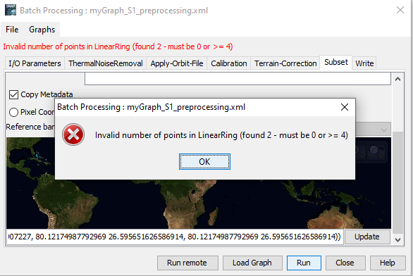
looks like the list of coordinates has changed. How did you define your subset?
I am using the WKT of the shapefile, derived from QGIS for the coordinates for subset.
can you please share the xml of the graph?
Please find the attached xml file: myGraph_S1_preprocessing.xml (6.4 KB)
you selected UTM 31N as target projection in the Range Doppler Terrain coorection, but your subset coordinates are in geographical coordinates (lat/lon, WGS84)
That graph is working fine with a single image. But showing this type of error while doing batch processing with multiple image files.
well, you did not mention this in the beginning.
Maybe one image covers a different area (subset not within)?
My problem has solved. I tried again by changing the coordinate system. Its working fine now.
Thank you for your assistance.