Problem with Terrain Correction - output misplaced

Hi,

I am working on SNAP 8.0 using Sentinel-1 GDR EW product but the output of my terrain correction step is always misplaced by approx. 250m.

Offset_example

After reading several related threads I have tried the following options with no success:

  1. Different map projections.
  2. Reprojecting to another projection after the terrain correction step.
  3. Setting align-to-grid to be true in my graph xml file.
  4. Setting ExternalDEMApplyEGM to be false in the graph xml file.

Can anyone tell me where I am going wrong? I have attached my graph xml file.

S1PreProGraphEW_Map.xml (6.4 KB)

Many thanks in advance.

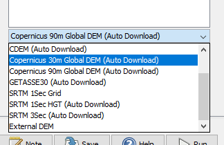
According to the XML you use GETASSE30 as the DEM. Its spatial resolution is 30 arc seconds which is roughly one kilometer. Fine scaled topographic changes won’t be corrected with this DEM. Can you try with the Copernicus DEM instead?

Thank you for the reply. The Copernicus DEM isn’t an option in the drop-down menu to auto download as the GETASSE30 DEM is. Do I need to download it and then use the external DEM option? Thanks.

It should be there as an option.

grafik

Please make sure you install all updates.