Problems with the Range Doppler Terrain Correction tool

Hello, a cordial greeting:

I have a problem when I use this tool I get the following message:
A problem occurred during the target product initialisation.
Type: OperatorException
Message: Source product should first be deburst.

I would like to know what solution or what I should do, I already uninstalled the software and reinstalled it, I have tried several things that I have seen in similar questions and nothing has worked for me.

I really appreciate anyone who can help me.

Please consult the FAQ “Read This Before Posting”. Provide enough detail so that others can reproduce your problem: OS and version, SNAP version, your input data. If you are following a tutorial document you should mention the document you are using.

I have already consulted them, however, the options that are detailed in other similar problems do not work for my problem and I have already tried them, download some images of Sentinel 1, band B, to make some coverage classifications, when carrying out the correction processes and others steps required, I try to perform the range Doppler terrain correction processing and it won’t let me do it, I’m trying to see if trimming and making the area a little smaller fixes the problem, however any other process or suggestion would be greatly appreciated.

Have you consulted SNAP tutorials and followed the instructed processing-steps?

Hello, thank you very much, if I followed the steps that I found on the SNAP youtube page and it did not work

There are more tutorials in here:

SNAP Tutorials – STEP (esa.int)

If you are new to SAR you should start with the basics before attempting processing S-1 SLC:s. If you are not planning to do InSAR you should be working with GRD:s instead of SLC:s, as the processing is a lot simpler and faster.

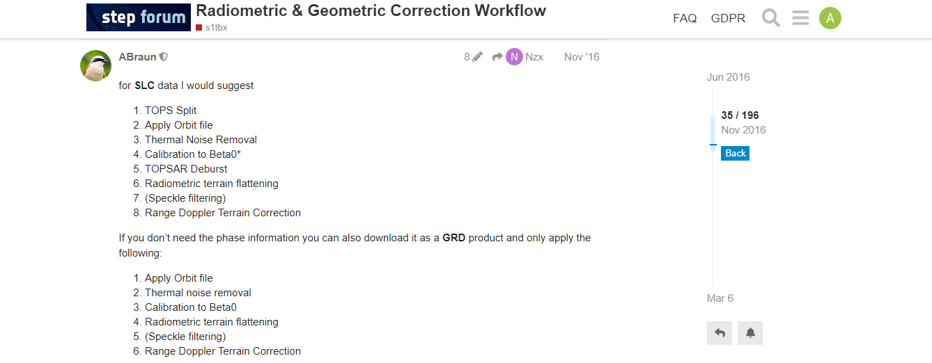
Thank you all for your answers, however I found the solution not in the FAQ, but in the link and process that I detail below, for which I am very grateful to Andreas Braun from Germany (ABraun) for providing these instructions and others

What is the use of Apply Gravitational Model checkbox when try to carry out Range Doppler Terrain Correction using external DEM?