Hello all,
I’m working with KOMPSAT-5 level1 (SCS) images to make them sigma0 for comparison with other images.
As I know, the process for radiometric calibration is
- Apply Orbit File
- Radiometric Calibrate to sigma0
- multilooking and speckle filtering (optional)
- Terrain Correction (geocoding)
I have some questions about this process.
First, what is the “Radiometric Terrain Flattening” and when does it need? is it necessary?
I think it is needed when there is much topography, how can I decide it?
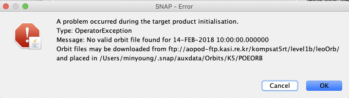
Second, if there is no orbit file, can I skip the apply orbit file stage?
When I tried to run the process, I got a message like this.
Finally, if I build a processing graph for the radiometric calibration, is it possible for me to apply it to other satellite images (TSX, CSK, etc) by changing only the input and output?