Hello everyone,
I’m quite new to SNAP.
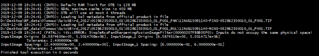
I’m trying to perform pan-sharpening on QuickBird multi-spectral image (2,4m/px) for which I have the PAN image (0,6m/px) with OTB toolbox methods. I was given a message that the images are not in the same physical space.
I’m not sure how this is possible as the images are taken for exactly the same location. However, in the world view pane, they have different centers.
I managed to get over this, when I reprojected the MUL image with the CRS of the PAN image. The CRS was the same tough, so I suppose that this isn’t a correct approach. In addition, when I performed other than bayes method, this message appears.
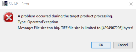
When trying to open the bayes pansharpened image in RGB window, it takes hours to load, sometimes there is an error. The file is 4GB. Is this normal?
I also pan-sharpened the QuickBird image in ArcGIS without any problem. However, when I export the image as a TIFF and import it to SNAP, it’s without any geolocation. Therefore I’m not able to upload my training data (shapefile) to it in order to perform the supervised classification.
Basically, what I’m trying to achieve is to perform the supervised classification on pansharpened QuickBird image with my already prepared training data. Is there some other way to do it?
Any help would be greatly appreciated!
I know that I can do this whole process in ArcGIS, but I wanted to try it in OpenSource software as well.