Hi,
Quick question about S2 L2A products. Why do we have pixels with BOA reflectance values == 0. For example:
Moreover, how to deal with this to avoid errors when doing raster math? Maybe changing it to a negative value?
Hi,
Quick question about S2 L2A products. Why do we have pixels with BOA reflectance values == 0. For example:
Moreover, how to deal with this to avoid errors when doing raster math? Maybe changing it to a negative value?
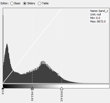
Dark Object Subtraction is part of the algorithm that transforms L1C into L2A (BOA reflectance) products.
If the pre-designated dark objects happen to be brighter than expected then the lower L2A values will be truncated at zero - as in your histogram.
I think.
This behaviour is set to change for products released under the up-coming Processing Baseline 04.00 - as announced here https://scihub.copernicus.eu/news/News00931
Provision of negative radiometric values (implementing an offset): Similarly to Level-1C, the dynamic range will be shifted by a band-dependent constant, i.e. BOA_ADD_OFFSET, as follows:
Digital Number DN=0 remains the “NO_DATA” value
For a given DN in [1;65535], the BOA reflectance value will be: L2A_BOAi = (L2A_DNi + BOA_ADD_OFFSETi) / QUANTIFICATION_VALUEi. The radiometric offset value will be consistent with the one applied to the Level-1C product and will be reported in a new field in the General_Info/Product_Image_Characteristics section of the Tile Metadata. It is also noted that the percentage of negative surface reflectance pixels per band will be also reported in the L2A_QUALITY report in the QI_DATA folder of the tile.
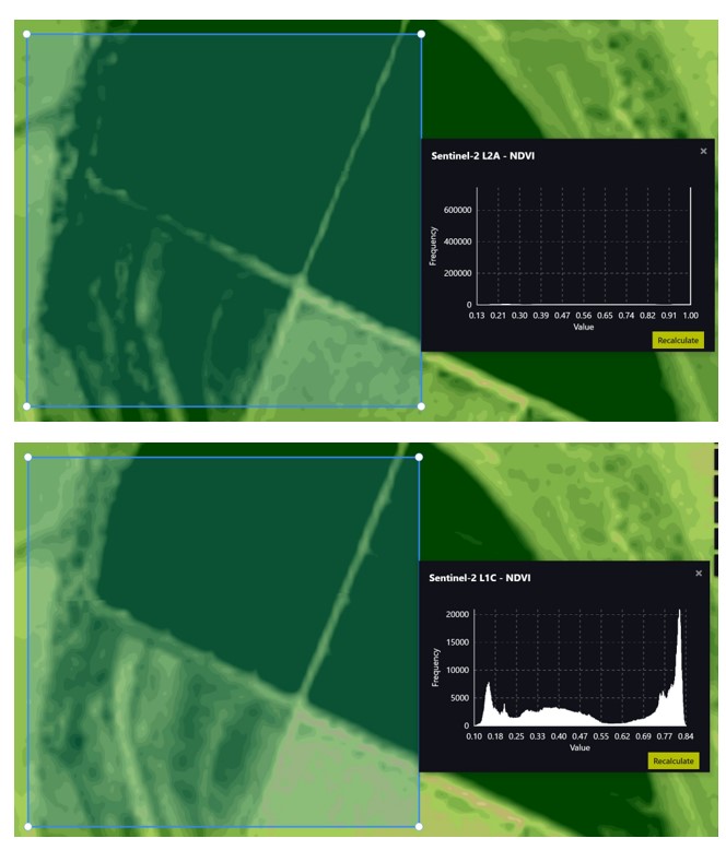
I have a similar question. I am noticing L2A data on Sentinel-Hub and Google Earth Engine sometimes has RGB reflectances at or near 0, causing NDVI = (NIR-R)/(NIR+R) to be = 1. It seems the optical bands are being over-corrected in some cases?
I can’t post links unfortunately, but it’s the 2022-12-29 image at 143.8499,-35.1376.
The NDVI histogram is saturated at 1. On the other hand, looking at the same scene using the L1C product, there is a nicely distributed NDVI histogram. So the SR calibration is causing information loss.
I’m not a remote sensing theory expert, would appreciate any input into what is going on here!
Here’s an example from Sentinel-Hub - you can check the image NDVI histogram:
The NDVI histogram is saturated at 1. On the other hand, looking at the same scene using the L1C product, there is a nicely distributed NDVI histogram. So the SR calibration is causing information loss.
Here’s an earth engine script showing the same thing, also that overlapping L2A tiles from the same date and same geometry have different calibrations causing vertical lines in the time-series:
https://code.earthengine.google.com/cd89de540f8153b112dd3b6a091867de
Hi @gbrelstaff ,
I have a very general question on the provision of negative pixel values in S2L2A from PB 4.00
I was looking for some documentation from ESA which elaborates more on the use of negative pixel values.
From some of the forums I could only figure out that these are darker pixels and I have an option to keep them as negative or scale it to 0.
I would like to more of what’s the benefit of keeping them as negative and vice versa.
P.S : Sorry for replying to an old thread. I just could not find an option to start a new one.
Best Regards,
Vijay
I can’t help you on that particular question sorry.