I have encountered a bug while reprojecting an OLCI EFR scene which seems to be adding ghost pixels very far away from the scene center. I have noticed this for quite a number of scenes when attempting to reproject and wondering if this is a bug or that I am missing something.
–Edit–
It seems that turning off per-pixel geocoding (using the tie point grids) fixes this issue. —
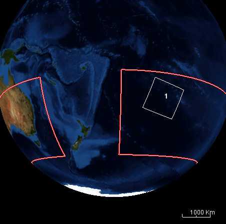
Source image bounding box according to the source geo_coordinates.nc (the sci hub footprint also agrees with this)
Upper Left lon/lat (degrees): -160.42,-20.58
Lower Right lon/lat (degrees): -144.45,-34.05
Output bounding box (via gdal):
Upper Left (-168.8932150, -18.7364568) (168d53’35.57"W, 18d44’11.24"S)
Lower Right ( 160.5098426, -49.0349038) (160d30’35.43"E, 49d 2’ 5.65"S)
If anyone else has encountered this issue and guidance would be appreciated.
this issue is now recorded in our issue tracker (SNAP-954).
We know that the pixel-based GeoCoding has some issues, especially when reprojecting the data.
That’s why we recently started a dedicated task to improve it. Unfortunately, the current situation does not allow us to spent much time on it. I hope this will change soon.
Maybe in early October, I can have a look at this particular issue, to lower the problem at least.
But quick-fixes will probably not help much.
The tie-points work better, as you have noticed, when reprojecting the data. But the accuracy of the tie-points is not very high, unfortunately, this is inherent to the provided data.
Side note: Do NOT turn off per-pixel geocoding when reprojecting S3 OLCI products - you might experience a random geometric shift in the reprojected image (at least I did).