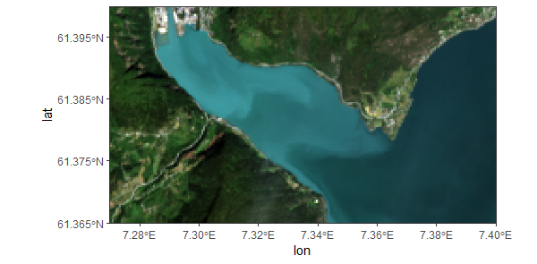
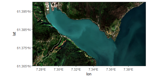
Hi, I have these two images that I processed in SNAP that I cropped to the same coordinates and reprojected to the same coordinate system, so they should show the same, but they look just a little bit off? It’s difficult to see (at least for me) but on the headland in the upper right corner you see that it’s not the same in both pictures, and the road on the lower left is also in a slightly different place.
Did I make a mistake somewhere? I don’t really understand projection very well so it is pretty likely that it’s my fault. It says the coordinate system is WGS 84 for both images so I’m not sure what went wrong. But if they were a different projection, the latitude and longitude axes should also change more between the pictures, right?
The first (Landsat) image was processed in acolite, then reprojected in SNAP. The second (Sentinel-2) image was processed with Sen2Cor and reprojected in SNAP as well. The plots are done in R. Please let me know if you need any more information.
In general, common reasons for the sort of differences you see are small differences in the numerical approximations used by different software and different choices for the “reference point” in a pixel. The most common reference points are the corners or the center of a pixel, so 1/2 pixel differences are not unusual when comparing data from different sources. If you can identify a few landmarks with known locations (buildings or road intersections?) you can check for consistent 0.5 pixel differences. Numerical approximation differences are usually smaller than a half-pixel in remote sensing imagery.
I think it is slightly more than 0.5 pixel differences. In the corners it looks like it might be about 10 pixels. It looks a bit like the whole image is just slightly rotated and skewed? I can only see it when I have them open on top of each other and look at one, then the other.
That suggests a problem with one of the mappings. If you can find a few reference points you may be able to narrow down the step that introduced the error.
To go sure about the offset, you could use the collocation tool to bring both data into one product (with Sentinel-2 as reference to maintain its higher spatial resolution) and then use the Layer Manager to swipe between both products and compare their offset. An example is given here, starting at about 4:10.