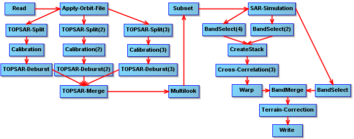
The following solution is more a successful work-around by re-implementing “SAR Simulation Terrain Correction” in a way that it does output the simulated intensity.
The following graph coregisters all slave bands (here VV and VH) [defined by BandSelect(4)] using the “create Stack” tool for which - as a first input - I used the simulated intensity [BandSelect(2)]. Then, every band is correlated against the master-band (simulated intensity) and warped accordingly. To preserve the layover-shadow mask it bypasses the Cross-correlation via “BandSelect” and is then “Band Merged” to the slave-bands VV, VH and the master band “simulated intensity”. All bands are then orthorectified using “Terrain Correction”.
Unfortunately, there seems to be no help file for “Band Select”. But an important info from Iveci (BandSelect: Band Name Pattern) is that regular expression pattern matching can be used to select bands (in my case “Beta0.+” in BandSelect(4) and just “Simulated_Intensity” in BandSelect(2)).
S1_multiswath_orthorectify_beta0_SARsim_BandSelectMergeLayover.xml (15.9 KB)
The result is the following:
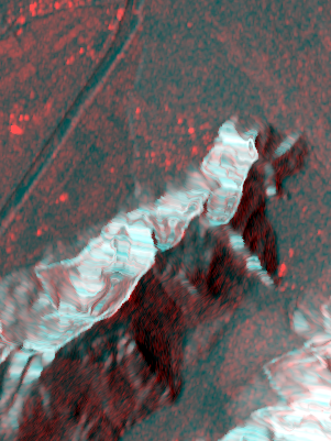
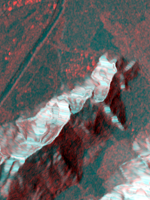
Left: VV, Right VH. (red: measured backscatter, green+blue: simulated backscatter).
With this method, I think, it is not required to coregister a series of SAR images before applying another coregistration to the simulated intensity. Now, everything (SAR images from different orbits, polarizations, etc.) can be coregistered precisely to the DEM. It should be possible to apply the graph using the batch tool. I will test.
Note, that the method is only suitable for precisely coregistering backscatter intensity with a DEM. Not sure how it could (or should) be generalized for interferometric purposes.