Anyone can share the experience with SBAS based on Sentinel 1A in SNAP 5.0? I have searched some topics, and found SBAS seems much more complicated. Workflow to conduct a SBAS Interferometry is not clear. Thanks.
Best wishes.
Please take a look at this,
1 Like
Thanks for your response. I note that lveci said that the export for SBAS has not yet been started. So how can I conduct the SBAS interferometry?
Are you looking for the step method how to implement this technique? or Do you ask about software?
sorry, falahfakhri. I didn’t mention the question clearly. I’m looking for the step method how to implement this technique. Thanks
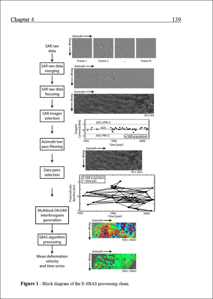
The reference: http://www.diee.unica.it/DRIEI/tesi/21_casu.pdf
I’m working to translate these steps in SNAP, waiting the new release V.6
3 Likes
Thanks. We are looking forward for this new release V.6.
hi, can I ask something, can we do interferometry analysis in vegetation area such as paddy crop?
Will the backscatter of paddy crop absorb the fringe pattern of the area?
tq
most likely yes. But you can compare coherence of images between different dates.
1 Like
Thanks for your response and the good link, Sir. Actually my objective is to determine the height of paddy crop using InSAR in order to differentiate between healthy and unhealthy tree. I have done with different date of images, but the coherence and phase image is not really good. somebody told me that for vegetation area, is not suitable to do InSAR. So I was confused. will study the references given, thanks a lot.
Vegetation is a quite unstable scatterer which makes common interferometry nearly impossible, especially height estimates.
There are approaches which use polarimetric InSAR but I’m afraid this is nothing that can be done in SNAP.
Does InSAR technology workto determine the height of paddy crop?Have you found another new method to achieve your objective? ![]()
I don’t think that because you need high coherence for interferometry and decorrelation is too high over vegetation or crops.
my analysis to determine the paddy crop height was failed. still looking for another way. 