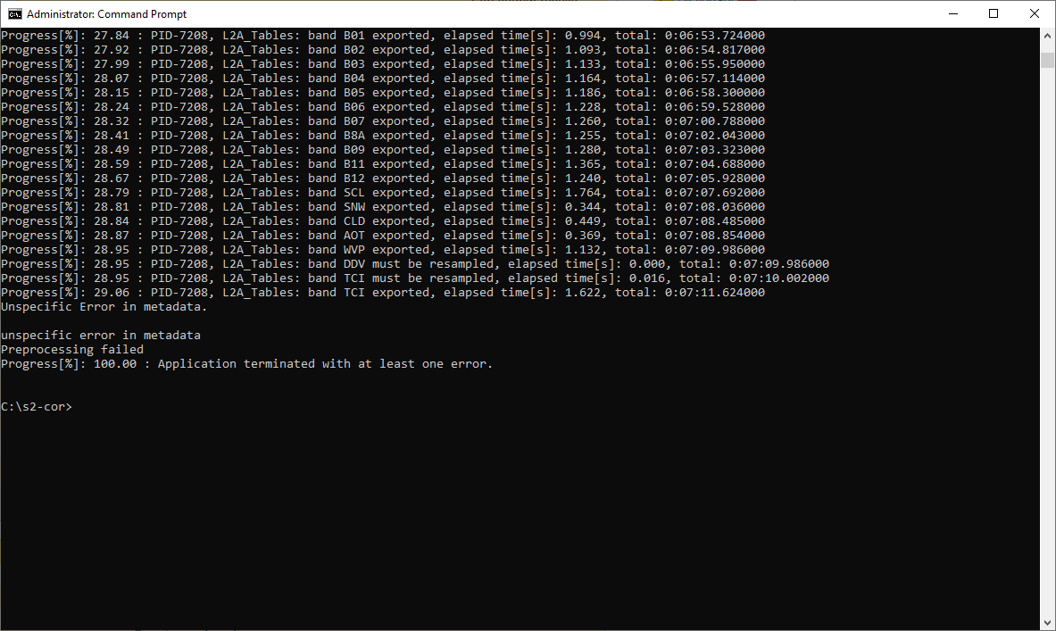
I saved the parameter file you mentioned under a new name and changed some parameters. That is the file:
<?xml version="1.0" encoding="UTF-8"?>
<Level-2A_Ground_Image_Processing_Parameter xmlns:xsi="http://www.w3.org/2001/XMLSchema-instance" xsi:noNamespaceSchemaLocation="L2A_GIPP.xsd">
  <Common_Section>
    <Log_Level>INFO</Log_Level>
    <!-- can be: NOTSET, DEBUG, INFO, WARNING, ERROR, CRITICAL -->
    <Nr_Threads>AUTO</Nr_Threads>
    <!-- Nr_Treads determines the number of threads used for reading the OpenJPEG2 images. This is a new
         feature implemented with OpenJPEG 2.3., improving the speed for importing the Bands.
         If AUTO is chosen, the number of treads are deduced, using cpu_count().
         Set this to 1 up to a maximum of 8, if this automatic mode will not fit to your platform -->
    <DEM_Directory>C:\Users\lukaswimmer\Desktop\RiShi_0619\data\accuracy\s2-shesh\DEM</DEM_Directory>
    <!-- should be either a directory in the sen2cor home folder or 'NONE'. If NONE, no DEM will be used -->
    <DEM_Reference>http://data_public:GDdci@data.cgiar-csi.org/srtm/tiles/GeoTIFF/</DEM_Reference>
    <!-- DEM_Reference>http://data_public:GDdci@data.cgiar-csi.org/srtm/tiles/GeoTIFF/</DEM_Reference -->
    <!-- disable / enable the upper two rows if you want to use an SRTM DEM -->
    <!-- The SRTM DEM will then be downloaded from this reference, if no local DEM is available -->
    <!-- if you use Planet DEM you can optionally add the local path instead,
         which then will be inserted in the datastrip metadata -->
    <Generate_DEM_Output>FALSE</Generate_DEM_Output>
    <!-- FALSE: no DEM output, TRUE: store DEM in the AUX data directory -->
    <Generate_TCI_Output>TRUE</Generate_TCI_Output>
    <!-- FALSE: no TCI output, TRUE: store TCI in the IMAGE data directory -->
    <Generate_DDV_Output>FALSE</Generate_DDV_Output>
    <!-- FALSE: no DDV output, TRUE: store DDV in the QI_DATA directory -->
    <Downsample_20_to_60>TRUE</Downsample_20_to_60>
    <!-- TRUE: create additional 60m bands when 20m is processed -->
    <PSD_Scheme PSD_Version="14.2" PSD_Reference="S2-PDGS-TAS-DI-PSD-V14.2_Schema">
		<UP_Scheme_1C>S2_User_Product_Level-1C_Metadata</UP_Scheme_1C>
		<UP_Scheme_2A>S2_User_Product_Level-2A_Metadata</UP_Scheme_2A>
		<Tile_Scheme_1C>S2_PDI_Level-1C_Tile_Metadata</Tile_Scheme_1C>
		<Tile_Scheme_2A>S2_PDI_Level-2A_Tile_Metadata</Tile_Scheme_2A>
		<DS_Scheme_1C>S2_PDI_Level-1C_Datastrip_Metadata</DS_Scheme_1C>
		<DS_Scheme_2A>S2_PDI_Level-2A_Datastrip_Metadata</DS_Scheme_2A>
    </PSD_Scheme>
    <PSD_Scheme PSD_Version="14.5" PSD_Reference="S2-PDGS-TAS-DI-PSD-V14.5_Schema">
		<UP_Scheme_1C>S2_User_Product_Level-1C_Metadata</UP_Scheme_1C>
		<UP_Scheme_2A>S2_User_Product_Level-2A_Metadata</UP_Scheme_2A>
		<Tile_Scheme_1C>S2_PDI_Level-1C_Tile_Metadata</Tile_Scheme_1C>
		<Tile_Scheme_2A>S2_PDI_Level-2A_Tile_Metadata</Tile_Scheme_2A>
		<DS_Scheme_1C>S2_PDI_Level-1C_Datastrip_Metadata</DS_Scheme_1C>
		<DS_Scheme_2A>S2_PDI_Level-2A_Datastrip_Metadata</DS_Scheme_2A>
	</PSD_Scheme>
    <GIPP_Scheme>L2A_GIPP</GIPP_Scheme>
    <SC_Scheme>L2A_CAL_SC_GIPP</SC_Scheme>
    <AC_Scheme>L2A_CAL_AC_GIPP</AC_Scheme>
    <PB_Scheme>L2A_PB_GIPP</PB_Scheme>
  </Common_Section>
  <Scene_Classification>
    <Filters>
      <Median_Filter>0</Median_Filter>
    </Filters>
  </Scene_Classification>
  <Atmospheric_Correction>
    <Look_Up_Tables>
      <Aerosol_Type>RURAL</Aerosol_Type>
      <!-- RURAL, MARITIME, AUTO -->
      <Mid_Latitude>AUTO</Mid_Latitude>
      <!-- SUMMER, WINTER, AUTO -->
      <Ozone_Content>0</Ozone_Content>
      <!-- The atmospheric temperature profile and ozone content in Dobson Unit (DU)
      	0: to get the best approximation from metadata
      	(this is the smallest difference between metadata and column DU),
      	else select one of:
      	==========================================
        For midlatitude summer (MS) atmosphere:
        250, 290, 331 (standard MS), 370, 410, 450
        ==========================================
        For midlatitude winter (MW) atmosphere:
        250, 290, 330, 377 (standard MW), 420, 460
        ==========================================
       -->
    </Look_Up_Tables>
    <Flags>
      <WV_Correction>1</WV_Correction>
      <!-- 0: No WV correction, 1: only 940 nm bands, 2: only 1130 nm bands , 3: both regions used during wv retrieval, 4: Thermal region -->
      <VIS_Update_Mode>1</VIS_Update_Mode>
      <!-- 0: constant, 1: variable visibility -->
      <WV_Watermask>1</WV_Watermask>
      <!-- 0: not replaced, 1: land-average, 2: line-average -->
      <Cirrus_Correction>FALSE</Cirrus_Correction>
      <!-- FALSE: no cirrus correction applied, TRUE: cirrus correction applied -->
      <DEM_Terrain_Correction>TRUE</DEM_Terrain_Correction>
      <!--Use DEM for Terrain Correction, otherwise only used for WVP and AOT -->
      <BRDF_Correction>0</BRDF_Correction>
      <!-- 0: no BRDF correction, 1, 2, 11, 12, 22, 21: see IODD for explanation -->
      <BRDF_Lower_Bound>0.22</BRDF_Lower_Bound>
      <!-- In most cases, g=0.2 to 0.25 is adequate, in extreme cases of overcorrection g=0.1 should be applied -->
    </Flags>
    <Calibration>
      <Adj_Km>1.000</Adj_Km>
      <!-- Adjancency Range [km] -->
      <Visibility>23.0</Visibility>
      <!-- visibility (5 <= visib <= 120 km) -->
      <Altitude>0.100</Altitude>
      <!-- [km] -->
      <Smooth_WV_Map>100.0</Smooth_WV_Map>
      <!-- length of square box, [meters] -->
      <WV_Threshold_Cirrus>0.25</WV_Threshold_Cirrus>
      <!-- water vapor threshold to switch off cirrus algorithm [cm]Range: 0.1-1.0 -->
      <Database_Compression_Level>0</Database_Compression_Level>
      <!-- zlib compression level for image database [0-9, 0: best speed, 9: best size] -->
    </Calibration>
  </Atmospheric_Correction>
</Level-2A_Ground_Image_Processing_Parameter>