Hi,
I open a S1 GRD image in EO and visualize the VV_linear gamma0 and get the statistics for my desired point (see the screenshot). The EO browser for July 19th 2021, gives me gamma0=4.68 but when I process the GRD image in SNAP (open GRD, apply orbit > thermal noise removal > calibrate which gives me gamma0, beta0 and sigma0) I see the gamma0 is different and that is 2.29946. Why do I get different values in SNAP and EO? Do I miss any step or something is wrong with EO statistics?
Any help is appreciated.
Gamma0 strongly depends on the underlying DEM. Do you know which one is used in the EO Browser? Also, different types of resampling, e.g.because of different target projections during the Range Doppler Terrain Correction could lead to different values or slightly shifted pixel positions, again because of differences in the DEM.
Thanks @ABraun for your reply. I don’t know which DEM EO Browser uses but I used Copernicus 30 meters for range Doppler train correction in SNAP. By the way, do you think if we compare the gamm0 in VV_linear _Gamma (not orthorectified) we get the same values in both EO and SNAP? Unfortunately, EO gives the statistics only on orthorectified gamma0, otherwise I could compare it with SNAP results.
You only have gamma_0 after the processing steps (which should include terrain correction, btw). The input level 1 GRD is NOT gamma_0 but some non-calibrated detected intensity value in ground-range geometry.
@glemoine this is correct, but he stated that he conducted these steps after importing the GRD product.
Also, the data in the EO browser has these steps applied. I guess it is either the projection, the DEM or the resampling. Which target projection did you select for your data?
The EO browser seeems to display the data in the Web Mercator projection (EPSG:3785)
Thanks @ABraun and @gmilcinski for your replies. For your info, I am trying to see the peak value of gamma0 for a corner reflector, so even if the map projection is different, the peak value for the pixels on the right corner (shown in the image) in both (SNAP and EO) should be the same (just might have the shift in location). As you can see the corner reflector is clearly visible and I can find it clearly in both EO and SANP images with any map projection (if different which I don’t think so) and then find the pixel with the peak value. So, I don’t think the map projection here makes any problem.
As you suggested, I exported the GeoTiff and imported in SNAP to compare the values of gamma0 From EO, VV_linear gamma0 radiometric terrain corrected band, gamma0(peak) is 4.92 and is again different from SNAP. Any further help/tips please?
I would suggest to take a look at these two discussions, which might address (part of) your problem:
Beyond this I do not have good ideas.
If you provide exact steps that you are doing in way that can easily be reproduced, we might ask some engineer to look into it, but cannot promise you when.
I still do. According to this source bilinear resampling is applied during the Range Doppler Terrain Correction which leads to different pixel values if the map projection is not constant: Sentinel-1 GRD
Please try both 3857 and 4326 in SNAP to see how your pixel value changes.
Especially local peaks can drastically differ if the pixels are slightly shifted or rotated as a result of a different coordinate system. WGS84 is based on degrees, UTM or Web Mercator on metres.
Anything that affects resampling will cause the “corner reflector” to have a different peak value. So, that includes whether you used the correct recipe (which needs terrain correction), the DEM, pixel spacing, projection, etc. Terrain flattening not, because it will no longer be gamma_0. Try comparing what recipe EO Browser applies and compare to your own. There is likely a difference.
Hi again,
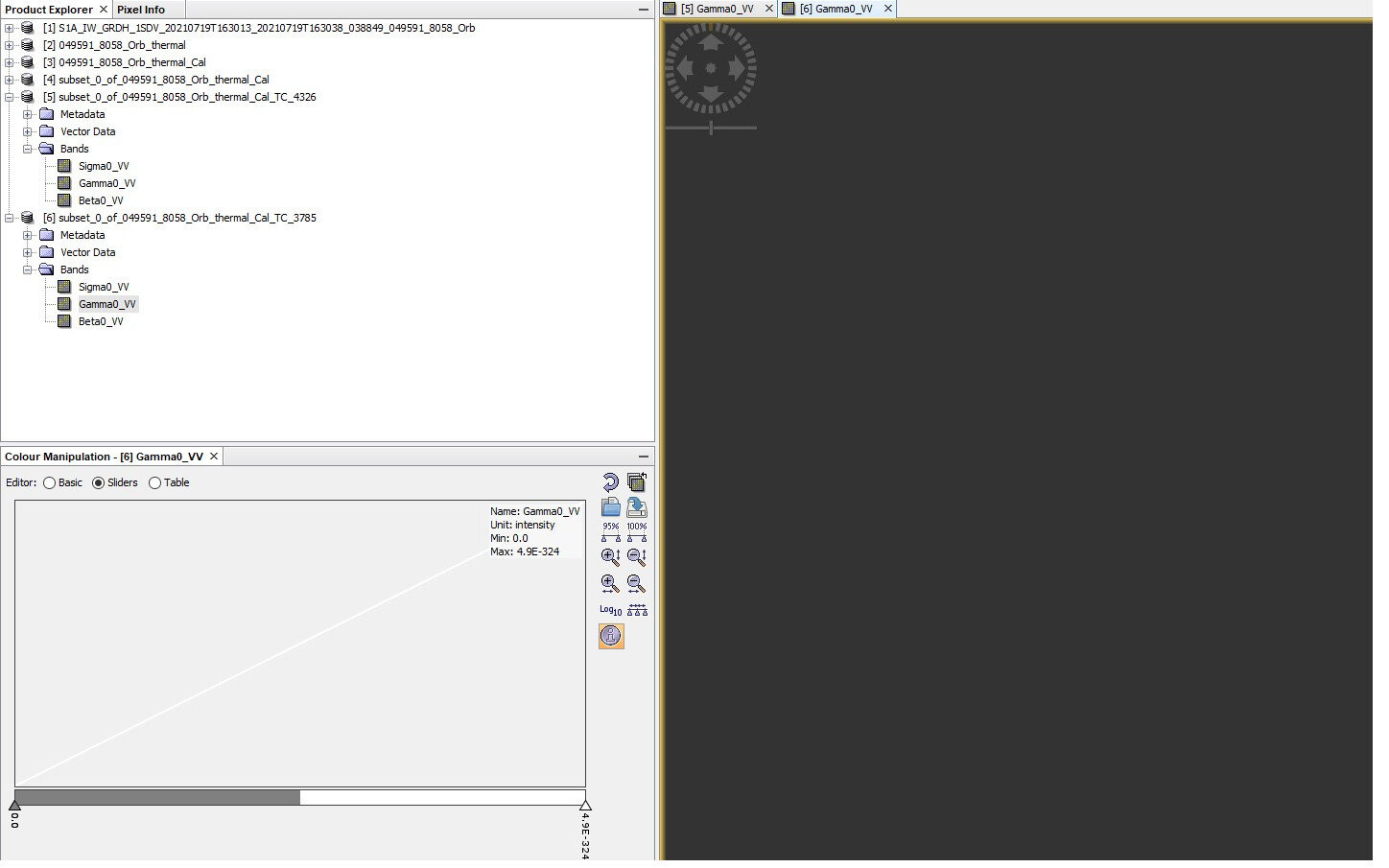
Thanks for all replies. I think I got you @ABraun now and I agree that map projection can change slightly the results. As you suggested, I tried both 3785 and 4326 in SNAP using Copernicus 30 meter, bilinear interpolation. I could get the TC results for 4326 (WGS84) and unfortunately not for 3785. I don’t know why it doesn’t show any results although the processing worked and I didn’t get any error message (please see the screenshots). Any idea why?
You can see in the screenshots the steps I have taken including making the subset image. It is intersting to know the subset image size (suggested by @gmilcinski) can change the results. In this case what is the proper size for the subset image can be a different and new question. I am not sure that question has been asked or if you can advise me for the proper size for subset.
The steps: Apply Orb, thermal noise removal, calibrate, subset (lats: 60.596,60.5936; long: 17.255,17.262), and then TC Range doppler terrain correction (Copernicus 30 m, bilinear, WGS84). If these steps are correct and similar to the EO (which seems they are, not sure), then still gamma0 values (from SNAP and EO) are different. Maybe the subset step makes problem?
Thanks,
Faramarz
I think I see a potential difference. The Gamma0 from EO Browser is different from how you calculated it (within Range Doppler Terrain Correction).
To get the terrain flattened Gamma0 as in EO Browser, please first calibrate to Beta0, then apply Radiometric Terrain Flattening (results in Gamma0). Then you can proceed with subset and TC.
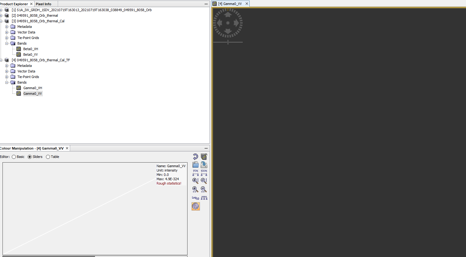
Thanks @ABraun for quick reply, In calibration stage, I get all gamma0, betta0 and sigma0, so perhaps it is already done(?). Do you mean I should just add one more step before the subset and that is Applying RTF?
Faramarz
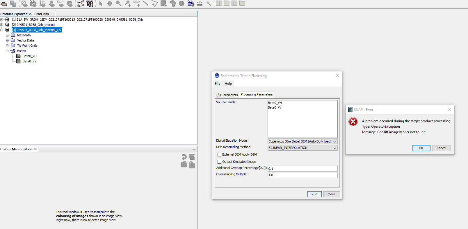
I see, thanks. So, I calibrated only for Beta0 and then tried to do RTF, but got a error message. please see the screen shot. Any suggestion to solve it? I have updated my SNAP and have the latest version.
No, I didn’t store, just in RTF process I got that error.
I can not use SRTM because the location (Lat) is above 60 degrees. I tried with Aster DEM, it finished without any error, but I see an empty image (see the screenshot please). Perhaps ASter DEM is not good too for this location. Probably SNAP has problem with the Copernicus DEM and makes GEOtiffread error. What else do you suggest please?