i found an intresting thing about the footprint of this Sentinel-3 product:
S3B_SL_2_LST____20190824T084906_20190824T103005_20190825T153619_6059_029_107______LN2_O_NT_003.SEN3
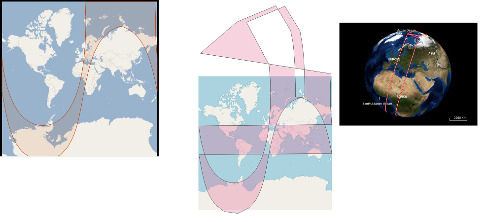
On Scihub, the footprint on the map seems valid. At the product details view, i have two footprint, which are different:
Footprint: this is in GML syntax > This can be found in the xfdumanifest.xml, under gml:posList key.
JTS footprint: this is in WKT syntax > This cannot be found in the Sentinel-3 metadata, but obviously the map footprint use this.
Here you can see how it looks this two polygon side by side (JTS and GML), and how it looks using the preview function of SNAP:
I would like to bouild a lightweight db using the products footprints, but what i found in the xfdumanifest.xml, is invalid. So my question is, where can i find the JTS footprint? Or if it’s not in the product, how should be generated it?
it would be great to have some extra information about this topic, because we need to calculate the real/valid footprint of the product. Many thanks for your cooperation!
Today I got the answer from the Copernicus EO Support, find below:
"We confirm that the JTS footprint is not included in the metadata and there is no plan to include it in the future (as far as we know). We don’t know JTS and thus we cannot help you to generate such footprint.
For your information, we invite you to look at the API available in the ESA SciHub which allows making queries by constraining the temporal window and/or the geographical areas."
Today i got this answer from the official Technical Support Team of the ESA.
Provided that the metadata contained in the products report only the GML coordinates and not the WKT coordinates, It is indeed possible to convert GML coordinates to WKT, as also explained by the user, but the conversion generates an invalid polygon that does not look right on a 2D map. In fact the area sensed by such kind of products (SLSTR L2 Land) is a full orbit stripe whose extremities overlap on the north pole. Moreover the stripe crosses the meridian of 180 degree of longitude. WKT cannot handle correctly a self-intersecting polygon (over the pole) and the split at the edges of the map (the 180 degree meridian). There is no easy/simple way to convert the WKT footprint to a valid one. In the DHuS software was developed an ad hoc algorithm which finds the appropriate points to keep and cuts the polygon in just the right places for showing it on the Mercator projection.