When I use gpt in a workflow on another PC everything runs smooth and i get my expected result (a clipped raster after an shapefile within the expected projection, with XxY dimensions). When I try the same gpt on my computer, with all the paths configured, the reprojection part of the .xml graphs somehow doesn’t give the expected result.
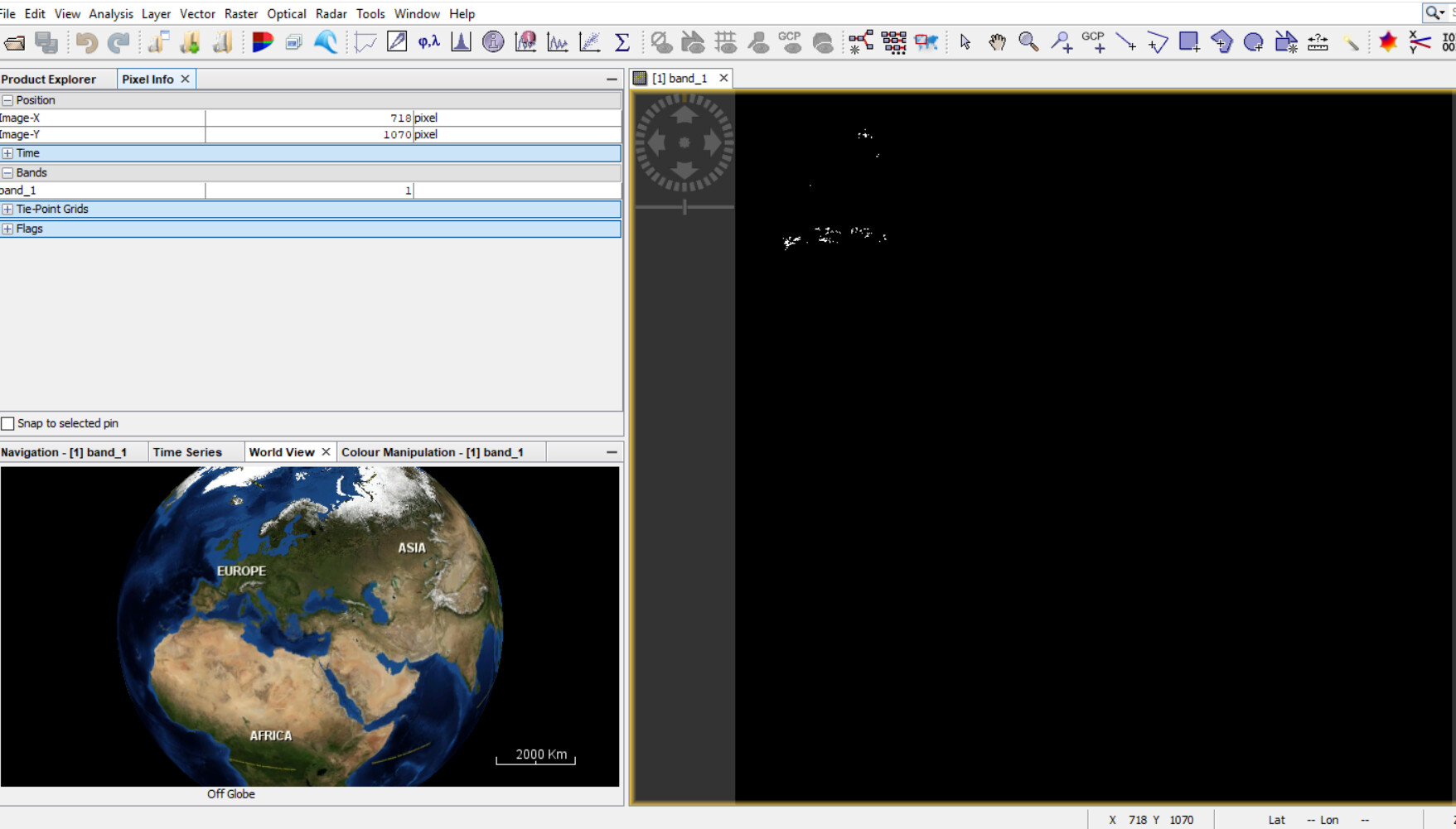
Why I say that? I get a raster with no projection but with the desired dimensions that are 5000x5000 cells. Everything in the processing chain it’s right but not the projection part. Where am I wrong?
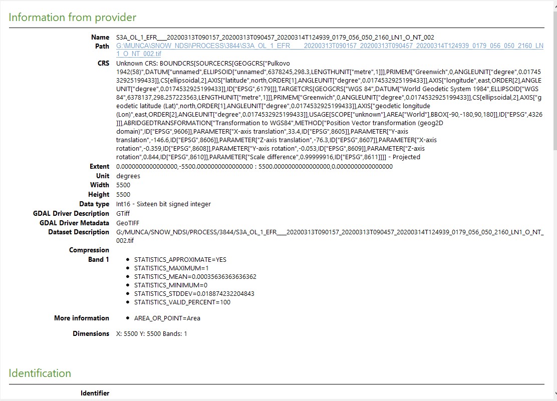
Hi, @marpet. Yes, I got the same versions of SNAP on both systems, 7.0. I didn’t upgrade the versions to 8.0. Even with the 3844 or 3857 CRS the results are also inappropriate. It’s like the Reproject part doesn’t recognize the projection. I set the X and Y dimensions, the easting and northing (that my files will got the same origin) but the only thing recognizable are de width and height. Even the header of the GeoTIFF is wrong, the files created on this system got only gibberish in their header but the ones created on the other system are complete. If you want i can attach you example of files created through the process that i want to implement.
I’m not sure what you mean by “a raster with no projection”. Are trying to view the projected raster in an output file and get a blank image or an image that has not been projected?
As you can see the data is not projected anywhere and the X and Y dimensions are the width and height that I set it in my Reprojection graph, 5000x5000.
Exactly the same issue. Now I see that QGIS populates CRS with some non-sense, it doesn’t recognize it. But when I change the CRS to 3857 (Pseudo Mercator) for tests only, the same issue pops up.
I repeat on another system with the same 7.0 SNAP version and the same processing chain everything runs smooth.
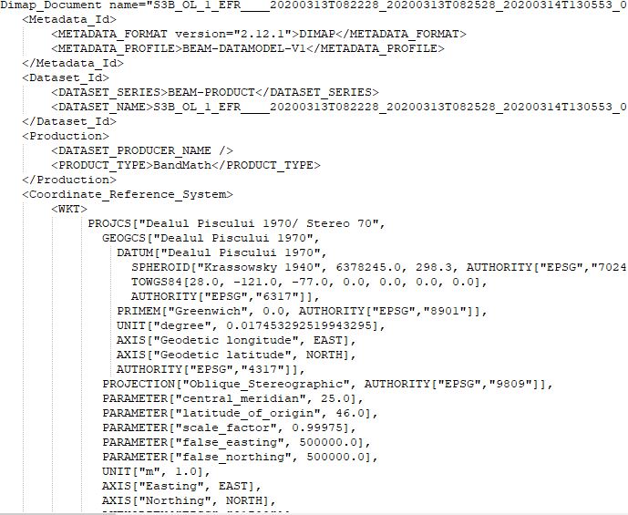
P.S. here is a snapshot from the working system with one GeoTIFF header opened in notepad++
The quickest fix is probably a reinstall on the non-working system (or upgrade to SNAP 8) but it would be nice to understand what causes the difference so the issue can be avoided in the future. You seem to be using Windows, where some libraries are often present in multiple copies and the first version loaded gets used in subsequent requests. Can you try rebooting and running the SNAP task before anything else? If this works, you are probably seeing a library conflict. Conflicts can also occur when a conflicting library is in a directory on the PATH, so the next step would be to run SNAP in console where you have manually set a minimal PATH. Some of the libraries can use environment variables to locate data files, so the final and hardest step is to try running snap with a “clean” environment by manually removing environment settings related to Visual Studio, QGIS, PROJ, JAVA, and GDAL. This will be easier if you can compare the environments between the 2 systems to see how they differ.