Hi…
i am working on calibration of SAR. i would like to deploy point target in this location lat 12°38’15.05"N
long 77°26’25.72"E… i am not much aware of sentinel orbit relative and pass detail but i know repeativity of sentinel is 12 days… it means is my area covered only once in 12 days …? pls clarify…in this case already my location is visited on 27-06-2017 so next visit ll be on 09-07-2017…? also to this location how to find the incidence angle…? because only with exact incidence angle and azimuth angle i could set the target exactly pointing towards sentinel…
1 Like
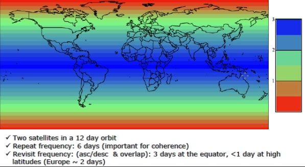
the theoretical repeat pass is 12 days (or 6 days with Sentinel-1B) but this strongly varies, depending from the observation scenarios:
https://sentinel.esa.int/web/sentinel/missions/sentinel-1/observation-scenario

Note that some areas can be observed from different tracks so the theoretical revisit time can shrink to a few days:
https://sentinel.esa.int/web/sentinel/user-guides/sentinel-1-sar/revisit-and-coverage
But as you said, only data from the same track grants same orientation of objects and surfaces towards the sensor.
Thank you ABraun… can you share anything about incidence angle… https://sentinel.esa.int/web/sentinel/user-guides/sentinel-1-sar/revisit-and-coverage in this link for every mode incidence angle is given to my location how to trace the incidence angle… this is very important for deploying the corner reflector…pls clarify it…
I would expect this information in the technical guide:
https://sentinel.esa.int/web/sentinel/technical-guides/sentinel-1-sar
If you open the product from 27-06-2017 on SNAP, you will see the incidence angle for every point of the image in ‘Product Explorer’ (this is the panel on the left of the screen), ‘Tie-Point Grids’, ‘incident_angle’. I guess this should be accurate enough. The future acquisitions along the same orbit will have very similar values of incidence angle.
For your task, you may also need the value in the ‘platformHeading’ field of the metadata files. According to the documentation, this will give you the ‘Platform heading relative to North [degrees].’
1 Like
Thank you @css… i ll check out…
Hi, Although Sentinel1-A and 1-B are in 12 day repeat periods, your location is likely to be imaged more than once per 12 days. This does however depend on the acquisition planning. You can find the latest planning at https://sentinel.esa.int/web/sentinel/missions/sentinel-1/observation-scenario/acquisition-segments and then select the latest S1-A and S1-B kml files for displaying in Google Earth. For your location in southern India, the next acquisitions are both with S1-A on 9th July and 21st July at around 00:40 UT. There are no planned S1-B acquisitions for your location. So for the moment your site is indeed imaged 12 days apart but it will be worth checking future planning.
For the orientation of your corner reflector (azimuth and elevation), I suggest you use the following website: http://www.heavens-above.com. You will need to select your location and then select the satellite (number 39634 for S1-A and 41456 for S1-B). At this point you can save the web address for future planning. If you then select ‘All Passes’ you will see a list of when Sentinel-1 is above your site horizon. Then select the pass which will image your site, i.e. 9th July at 06:10 local time. You will then see a sky map showing the path of the satellite and at the bottom of this page is a table. This table gives the altitude and azimuth at maximum altitude. You can use these number (51 and 101 deg) to orientate your corner reflector. We orientate our CR using the elevation of the base side of the corner, in which case you need to subtract 35 deg of the altitude for heavens-above to give 16 deg.
If any of the above is not clear, please reply.
Peter
5 Likes
Interesting.
I assume that will be the point of closest approach and guarantees that the radar will be at that time illuminating the CR, no?
Hi, Yes your assumption is correct. Peter
@peter.meadows
thanks Peter. … It’s quiet interesting to know about the planning and angle info…very helpful. …
HI @PETER,
I have a doubt…in the heavens-above website i have referred the table… also passes shown there are contradictory with sentinel kml file eg. in heaven-above there is no visible pass on 9th july over my location but incase of sentinel kml there is a pass on 09th july 6.40am local time…so shall i consider only sentinel kml file for pass reference and plan for deployment… also angle difference is there upto 5 deg compared to the old pass data … and as you mentioned 101 deg of azimuth, is it mentioned within the table…?..
other than heaven-above i used to refer http://www.n2yo.com for pass reference and angle measurement… but when it is mentioned(in n2yo.com) there is a excellent visible pass on my location i used to deploy CR with mentioned angle but once i checked in the sentinel website to download the data it won be available.then i had a coversation with Mr. Pete , Copernicus SCI team, who conveyed to refer the website https://sentinel.esa.int/web/sentinel/missions/sentinel-1/observation-scenario/acquisition-segments… what is your suggestion on this problem…? for pass reference-sentinel website
and for angle reference heaven-above …?which one i am bit confused…pls clarify…
Thanks in advance…
Hi, I have below attached a PDF file showing the various steps in using heavens-above to determine the altitude and azimuth angles that you can use to orientate your corner reflector. You should now be able to see the 9th July pass over your site.
The Copernicus SCI team have pointed to you the kml planning files. These indicate when your site will be imaged. Even though S1-A will be above your horizon more times than given in the kml files, the SAR will (a) not be able to image your site or (b) will not be operating at that time (the SAR operates for only about 40 minutes per orbit).
Let me know if the attached is clear.
Steps in using heavens.pdf (292.2 KB)
Peter
1 Like
thank you for the pdf i followed the same procedure to find elevation angle but from your pdf i ve understood about the azimuth angle determination clearly on selecting the particular date (09th July). but as it is given in the first table last column as per the heavens-above it was a daylight pass but whether the image is taken or not on that date is decided by sentinel switching on time(in kml planning files) isn’t it…?
really i appreciate you patience to prepare one large PDF to clarify my doubts… Hats off to your contribution …
FOR AZIMUTH should i need to subtract 90 deg from the actual spacecraft azimuth…because in one paper i ve read like that… the given angle is spacecraft azimuth so depends on right side looking or left side looking it has to be +/- from 90…
hi peter ,
i ve done the deployment as per the procedure given in pdf… thank you so much… now i ve downloaded the data of the date 09/07/2017. in theGRDH data i could locate my location as well as in quick look of all SLC,GRDH,RAW data i could locate my location but in SLC data i am trying to locate my place with lat and long…but no where i could because all the three Intensity_IW1_VH, Intensity_IW2_VH,Intensity_IW3_VH all covers only from long 77deg 38 min to 78deg 34min…but my lacation is having a long of 77deg 25 min 26 sec… hoe to work with the data…need some guidance…
thanks
Nathiya
Hi,
i ve done the deployment of my reflector at lat:12 deg 38 min 36 sec, long:77deg 26min 26 sec… now i ve downloaded the data of the date 09/07/2017. in the GRDH data i could locate my location as well as in quick look of all SLC,GRDH,RAW data i could locate my location but in SLC data i am trying to locate my place with lat and long…but no where i could because all the three Intensity_IW1_VH, Intensity_IW2_VH,Intensity_IW3_VH all covers only from long 77deg 38 min to 78deg 34min…but my lacation is having a long of 77deg 25 min 26 sec… how to work with the data…need some guidance…
thanks
Nathiya
Hi, Since you have found your location in the GRDH product, it is likely that the azimuth extent of the SLC product is slightly different. So I suggest you download the adjacent SLC products to find your location. If you deployed your corner reflector yesterday and it is a trihedral, then the response will only be in VV (or HH).
Peter
I ve tried with the adjacent product it locates properly what it has to be covered but not my location
https://scihub.copernicus.eu/dhus/odata/v1/Products(‘850b2f14-f43b-44d4-a246-4d8172ff34d3’)/$value.
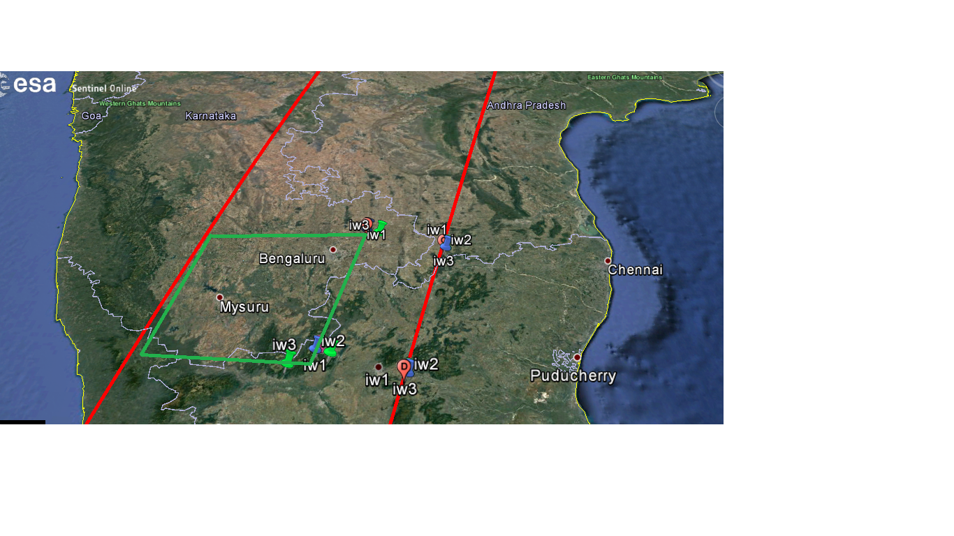
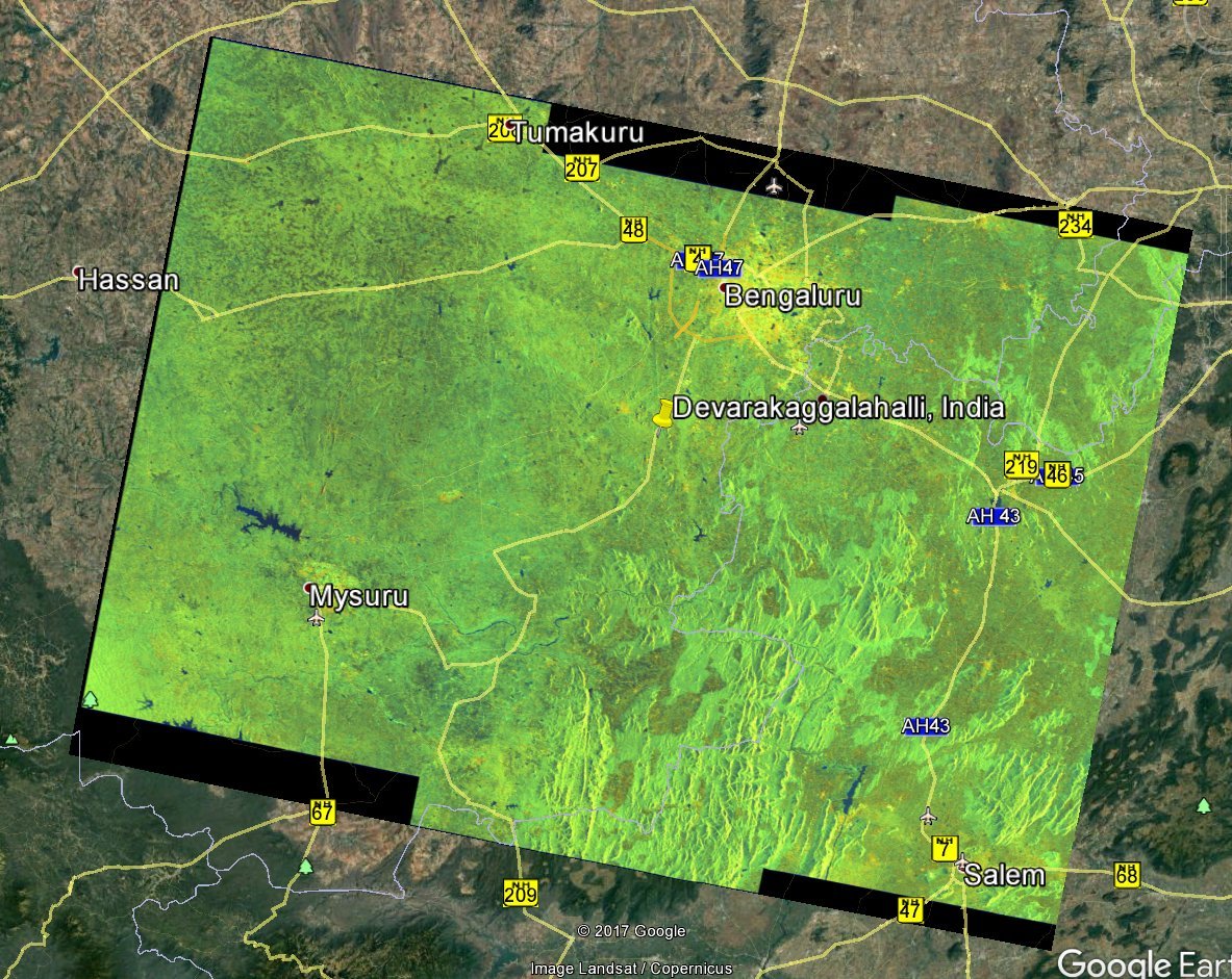
This is the product i’ ve downloaded and pls find the image file where i marked the three sub-width of IW1,IW2,IW3 which i got it from SLC product but green square is the place i am expecting for the data it is missing.