Hello,
I have some questions while I was using Sentinel-1 IW SLC images.
First, where can I get velocity information (satellite, ground(footprint) and effective)?
In some Sentinel documents, there is a calculation “Ve=sqrt(Vs*Vg)”, but I have no idea what each values are.
Also, chirp information (range chip length, chirp bandwidth, chirp sign, etc) could not be found except that the chirp source is ‘nominal’.
I want to know exact values about those for each images.
Third, in some documents, I could find followed one,
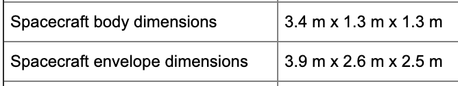
Then, which one is “effective” azimuth dimension between 3.4 and 3,9?
Last, as I know the satellite flies al 693km altitude, but I think the exact height would be different every scene. Is there any parameters about it?
Please let me know where I can find each information for each images.
–
I’m writing some questions about the Sentinel1 images.
To sum it up,
- Sensor and satellite velocity information (satellite, ground(footprint), effective)
- Image chirp information (range chip length, chirp bandwidth, chirp sign, etc)
- Effective antenna azimuth dimension
- Exact satellite altitude
Even if this is little different from SNAP, I would appreciate it if you let me know where I can find these.
Thank you