Shifting Sentinel-2 scenes

Hi, all!

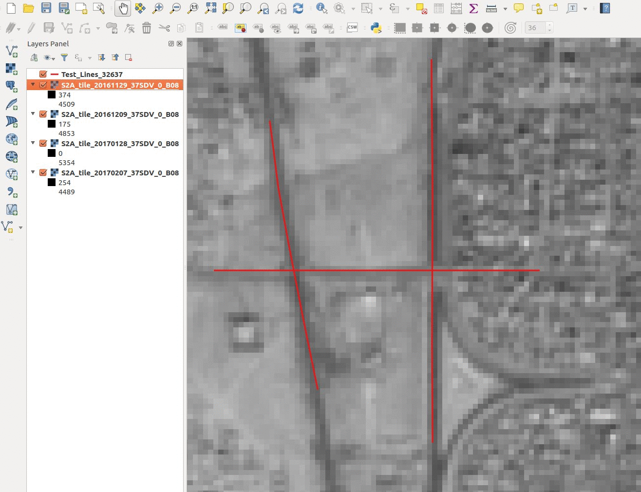
Recently found a number of scenes with strange non-linear deformations. Such scenes a lot. The difference in the angle of shooting is not more than 4-6 degrees. At a resolution of 10 meters (channel 8) there are strong differences in the binding. The shadow shows that the sun is shining from a different angle. But even under these conditions, unlikely to occur by such shifts, such as roads. What caused it?

The scene took raw to JPEG2000. Internal binding is the same (checked using gdalinfo).
The differences found in the scenes, beginning with the month of December.
Can anyone give the exact answer?

Best regards,
Igor.

Hi Igor,

In your Datastrip metadata, there is a field that denotes EPHEMERIS_QUALITY> I wonder what the values in the respective products are?

Also, if there is a FAILED test in the OLQC, it will be hlighted in the “Quality_Control_Checks”/ “Quality_Inspections” fields in the MTD_MSIL1C. The tests are:

  • SENSOR_QUALITY_FLAG
  • GEOMETRIC_QUALITY_FLAG
  • GENERAL_QUALITY_FLAG
  • FORMAT_CORRECTNESS_FLAG
  • RADIOMETRIC_QUALITY_FLAG

These flags are either PASSED or FAILED
If a test is FAILED, a report bearing the relevant title will be generated in the DS QI_DATA subfolder.

More information can be found in the Product Specification Document [PSD]

Cheers

Jan

S2 MPC Operations Manager

Hi Jan,

Checked only the scene of the first animation.
Everything seems normal. Information from https://scihub.copernicus.eu/ :

S2A_MSIL1C_20170207T081111_N0204_R078_T37SDV_20170207T081511
Format correctness: PASSED
General quality: PASSED
Generation time: 2017-02-07T08:15:11.000000Z
Geometric quality: PASSED
Ingestion Date: 2017-02-08T09:55:23.434Z
Mission datatake id: GS2A_20170207T081111_008512_N02.04
Orbit number (start): 8512
Pass direction: DESCENDING
Processing baseline: 02.04
Processing level: Level-1C
Product type: S2MSI1C
Radiometric quality: PASSED
Relative orbit (start): 78
Sensing start: 2017-02-07T08:11:11.026Z
Sensing stop: 2017-02-07T08:11:11.026Z
Sensor quality: PASSED

S2A_MSIL1C_20170128T081201_N0204_R078_T37SDV_20170128T081953
Format correctness: PASSED
General quality: PASSED
Generation time: 2017-01-28T08:19:53.000000Z
Geometric quality: PASSED
Ingestion Date: 2017-01-28T14:01:27.970Z
Mission datatake id: GS2A_20170128T081201_008369_N02.04
Orbit number (start): 8369
Pass direction: DESCENDING
Processing baseline: 02.04
Processing level: Level-1C
Product type: S2MSI1C
Radiometric quality: PASSED
Relative orbit (start): 78
Sensing start: 2017-01-28T08:12:01.026Z
Sensing stop: 2017-01-28T08:12:01.026Z
Sensor quality: PASSED

S2A_MSIL1C_20161209T081332_N0204_R078_T37SDV_20161209T081749
Format correctness: PASSED
General quality: PASSED
Generation time: 2016-12-09T08:17:49.000000Z
Geometric quality: PASSED
Ingestion Date: 2016-12-09T13:32:23.345Z
Mission datatake id: GS2A_20161209T081332_007654_N02.04
Orbit number (start): 7654
Pass direction: DESCENDING
Processing baseline: 02.04
Processing level: Level-1C
Product type: S2MSI1C
Radiometric quality: PASSED
Relative orbit (start): 78
Sensing start: 2016-12-09T08:13:32.026Z
Sensing stop: 2016-12-09T08:13:32.026Z
Sensor quality: PASSED

S2A_OPER_PRD_MSIL1C_PDMC_20161129T180749_R078_V20161129T081302_20161129T081302
Format correctness: PASSED
General quality: PASSED
Generation time: 2016-11-29T18:07:49.000284Z
Geometric quality: PASSED
Ingestion Date: 2016-11-29T18:47:54.008Z
Mission datatake id: GS2A_20161129T081302_007511_N02.04
Orbit number (start): 7511
Pass direction: DESCENDING
Processing baseline: 02.04
Processing level: Level-1C
Product type: S2MSI1C
Radiometric quality: PASSED
Relative orbit (start): 78
Sensing start: 2016-11-29T08:13:02.000Z
Sensing stop: 2016-11-29T08:13:02.000Z
Sensor quality: PASSED

Best regards,
Igor.

Two other scenes also normal:

S2A_MSIL1C_20170202T090201_N0204_R007_T35TPF_20170202T090155
Format correctness: PASSED
General quality: PASSED
Generation time: 2017-02-02T09:01:55.000000Z
Geometric quality: PASSED
Ingestion Date: 2017-02-02T14:31:47.175Z
Mission datatake id: GS2A_20170202T090201_008441_N02.04
Orbit number (start): 8441
Pass direction: DESCENDING
Processing baseline: 02.04
Processing level: Level-1C
Product type: S2MSI1C
Radiometric quality: PASSED
Relative orbit (start): 7
Sensing start: 2017-02-02T09:02:01.026Z
Sensing stop: 2017-02-02T09:02:01.026Z
Sensor quality: PASSED

S2A_MSIL1C_20161211T085342_N0204_R107_T35TPF_20161211T085344
Format correctness: PASSED
General quality: PASSED
Generation time: 2016-12-11T08:53:44.000000Z
Geometric quality: PASSED
Ingestion Date: 2016-12-11T16:01:11.833Z
Mission datatake id: GS2A_20161211T085342_007683_N02.04
Orbit number (start): 7683
Pass direction: DESCENDING
Processing baseline: 02.04
Processing level: Level-1C
Product type: S2MSI1C
Radiometric quality: PASSED
Relative orbit (start): 107
Sensing start: 2016-12-11T08:53:42.026Z
Sensing stop: 2016-12-11T08:53:42.026Z
Sensor quality: PASSED

Hi Igor

OK. And what are the values of the EPHEMERIS QUALITY in the DS for these Tiles? Can you find those and put them here, linking the Compact Filename with their EPHEMERIS_QUALITY values, please?

Cheers

Jan

EPHEMERIS_QUALITY.txt (3.0 KB)

Hi Igor,

Thanks. That all looks good - the values are all as I would expect them to be. I think we can therefore rule out issues in data quality, so it’s likely to do with variations in orbital dynamics between scenes.

I’ll have to think on it, and do some learning, too :slight_smile:

Cheers

Jan

1 Like

Dear Igor,

Regarding the first scene: I am not sure we can see a non-linear distortion here. It looks like a relatively standard shift that we can observe between two acquisitions. The typical shift between two successive acquisitions is 1.2 pixels at 95% confidence.

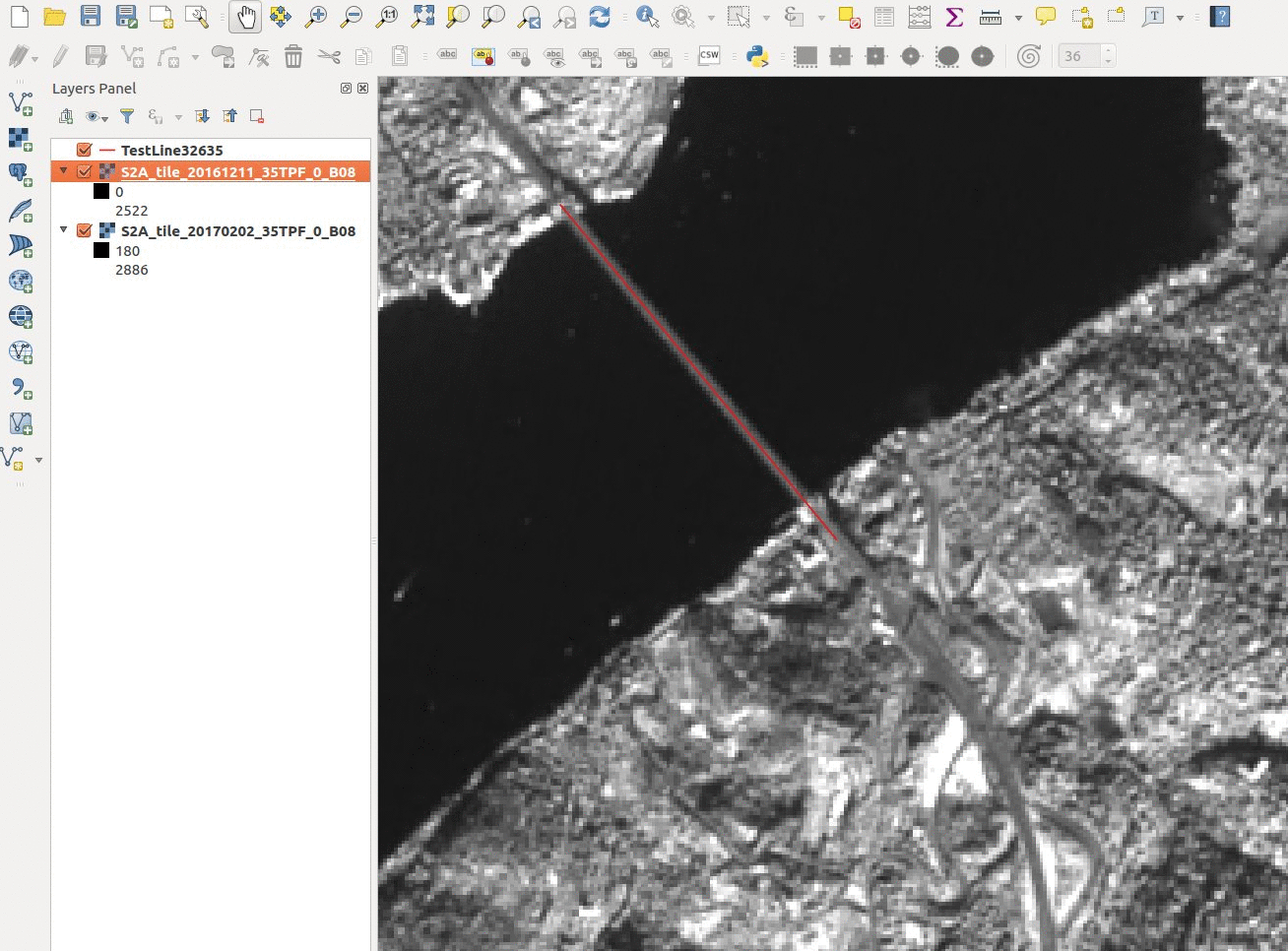
The second scene is very nice and interesting: the images are very well aligned but the bridge position changes. This is most probably a parallax effect coming from the fact that the bridge is not at ground level. Sentinel images are rectified according to a Digital Elevation Model (DEM) sampled at 90 m horizontal resolution. Fine details like the bridge cannot be represented, so the bridge will be projected to the water surface, at a position which depends from the viewing angle. If you have some spare time you could probably compute the altitude of the bridge with these two images. :wink:

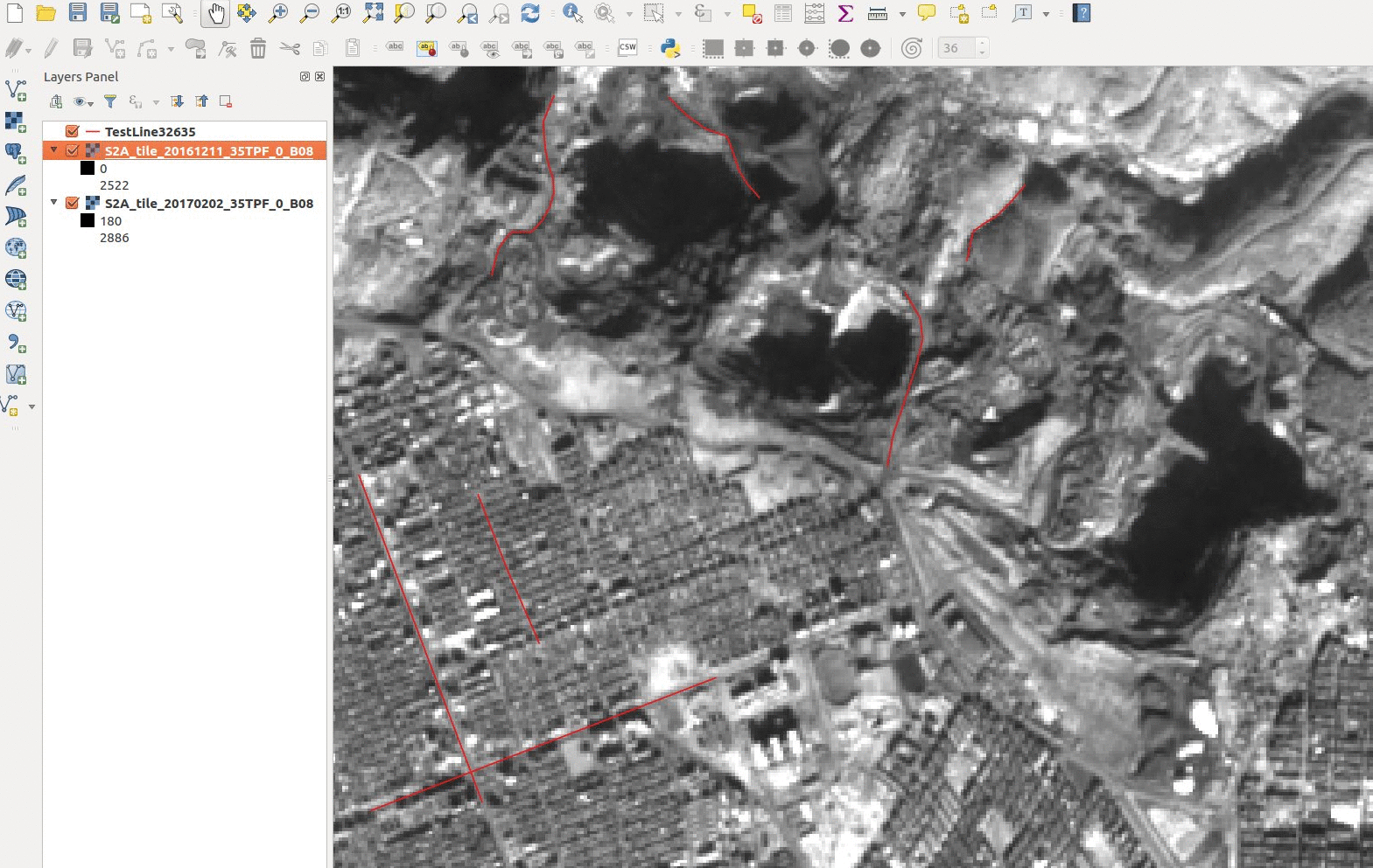
The third one looks like an open-sky mining site. The apparent shift around the holes could be due to a combination of a) shadowing effects b) on-going mining activity c) inaccuracy of the DEM in this evolving area.

Generally speaking, we can find some local distortions when comparing different repeat orbits in places where the DEM is not accurate. Improvement of the DEM accuracy is in the to-do list of the Sentinel-2 team, but this will require some time to implement.

Cheers,
SĂ©bastien CLERC
S2 Mission Performance Center Technical Manager

4 Likes

Dear SĂ©bastien,

Many thanks for the explanation. By DEM - I also tend to your version.
Congratulations to you and the whole team with the launch of Sentinel-2B. :rocket: :+1: :champagne:

With respect,
Igor

1 Like