Sure, sorry for that. I am asking to GGE too.
I was explaining , as a introduction, what I am done with GGE in order to compare with ESA GRD product.
Focused on GRD ESA, Sentinel -1 on -line documentation (https://sentinels.copernicus.eu/web/sentinel/user-guides/sentinel-1-sar/product-types-processing-levels/level-1) speak about GRD corrected (using the terrain height)…etc:
‘Level-1 Ground Range Detected (GRD) products consist of focused SAR data that has been detected, multi-looked and projected to ground range using the Earth ellipsoid model WGS84. The ellipsoid projection of the GRD products is corrected using the terrain height specified in the product general annotation. The terrain height used varies in azimuth but is constant in range (but can be different for each IW/EW sub-swath).’
but in order to get GRD georeferenced you need to pre-process the scene because doen not is showed (SNAP) georeferenced, this is my confusion.
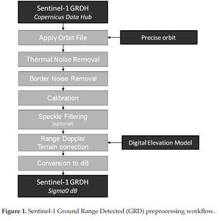
Several authors explain this processing as:
At the begining, I thought GRD ESA product was as Sentinel -1 on -line documentation explain,
Thanks,
Juanjo