Subsetting before Terrain Correction fails with SNAP 13 (almost sure it was working with SNAP12), both with the Subset Operator and with the advanced options in Read.
Command line :
gpt "D:\grd_s1_preprocess_default.xml" -Pfile="D:\S1B_IW_GRDH_1SDV_20191215T180300_20191215T180325_019379_0249B2_C99C.SAFE" -Pvector_file="geo_region.shp" -Pdem_name="Copernicus 30m Global DEM" -Pcrs
=EPSG:32630 -Pres_m=0.0 -Pres_deg=0.0 -Pout="D:\20191215T180300_S1_VV_VH_IW_GRD.dim"
Graph :
<graph id="Graph">
  <version>1.0</version>
  <node id="Read">
    <operator>Read</operator>
    <sources/>
    <parameters class="com.bc.ceres.binding.dom.XppDomElement">
      <file>${file}</file>
      <formatName>SENTINEL-1</formatName>
      <useAdvancedOptions>true</useAdvancedOptions>
      <copyMetadata>true</copyMetadata>
      <vectorFile>${vector_file}</vectorFile>
    </parameters>
  </node>
  <node id="Terrain-Correction">
    <operator>Terrain-Correction</operator>
    <sources>
      <sourceProduct refid="Read"/>
    </sources>
    <parameters class="com.bc.ceres.binding.dom.XppDomElement">
      <sourceBands/>
      <demName>${dem_name}</demName>
      <externalDEMFile>${dem_path}</externalDEMFile>
      <externalDEMNoDataValue>0.0</externalDEMNoDataValue>
      <externalDEMApplyEGM>true</externalDEMApplyEGM>
      <demResamplingMethod>BILINEAR_INTERPOLATION</demResamplingMethod>
      <imgResamplingMethod>BILINEAR_INTERPOLATION</imgResamplingMethod>
      <pixelSpacingInMeter>${res_m}</pixelSpacingInMeter>
      <pixelSpacingInDegree>${res_deg}</pixelSpacingInDegree>
      <mapProjection>${crs}</mapProjection>
      <nodataValueAtSea>false</nodataValueAtSea>
      <saveDEM>false</saveDEM>
      <saveLatLon>false</saveLatLon>
      <saveIncidenceAngleFromEllipsoid>false</saveIncidenceAngleFromEllipsoid>
      <saveLocalIncidenceAngle>false</saveLocalIncidenceAngle>
      <saveProjectedLocalIncidenceAngle>false</saveProjectedLocalIncidenceAngle>
      <saveSelectedSourceBand>true</saveSelectedSourceBand>
      <saveLayoverShadowMask>false</saveLayoverShadowMask>
      <outputComplex>false</outputComplex>
      <applyRadiometricNormalization>false</applyRadiometricNormalization>
      <saveSigmaNought>false</saveSigmaNought>
      <saveGammaNought>false</saveGammaNought>
      <saveBetaNought>false</saveBetaNought>
      <incidenceAngleForSigma0>Use projected local incidence angle from DEM</incidenceAngleForSigma0>
      <incidenceAngleForGamma0>Use projected local incidence angle from DEM</incidenceAngleForGamma0>
      <auxFile>Latest Auxiliary File</auxFile>
      <externalAuxFile/>
    </parameters>
  </node>
  <node id="LinearToFromdB">
    <operator>LinearToFromdB</operator>
    <sources>
      <sourceProduct refid="Terrain-Correction"/>
    </sources>
    <parameters class="com.bc.ceres.binding.dom.XppDomElement">
      <sourceBands/>
    </parameters>
  </node>
  <node id="Write">
    <operator>Write</operator>
    <sources>
      <sourceProduct refid="LinearToFromdB"/>
    </sources>
    <parameters class="com.bc.ceres.binding.dom.XppDomElement">
      <file>${out}</file>
      <formatName>BEAM-DIMAP</formatName>
    </parameters>
  </node>
</graph>
Vector file : geo_region.zip (895 Bytes)
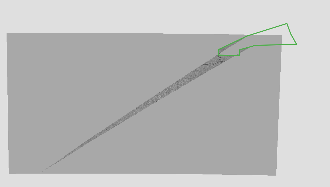
The vector is within the S1 extent :

Result : empty file
Executing processing graph
....12%...24%...36%...48%...60%...72%...84%..WARNING: eu.esa.sar.sar.gpf.geometric.RangeDopplerGeocodingOp: Terrain-Correction error: no valid output was produced. Please verify the DEM
 done.
____
Other tests gave me other strange results, also with geometryRegion
Some examples:
- other subsetting polygon in green, very strange result
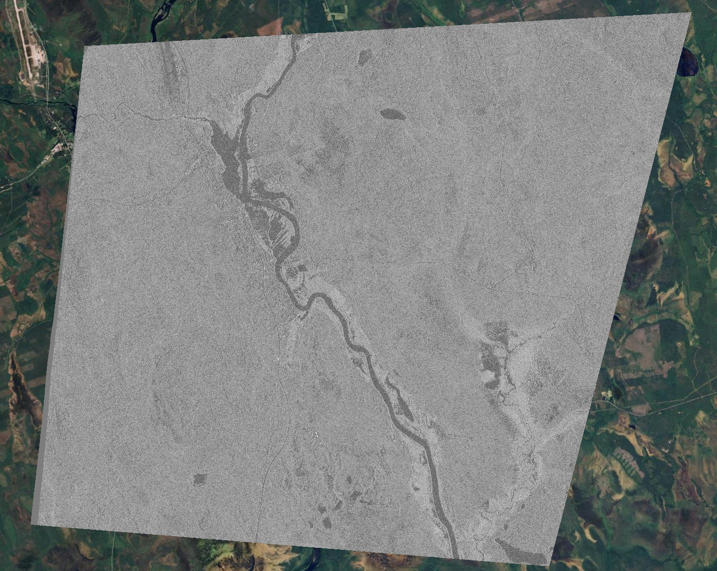
- Wrong orthorectification : the image is shifted (a lot)
Maybe linked to: Graph Builder Subset and Terrain Correction Error Sentinel 1 - #41 by Boorhin