SNAPHU Unwrapping

The Interferogram raster consists of only three bursts, I didn’t think it was heavy but it may take too long to process each burst individually.

According to your statement, aside from taking too long to unwrap so many rows, would that cause unwanted unwrapping errors? Hopefully not, because the interograms themselves don’t display a pronounced fringe pattern but I was told to continue to unwrapping step to see if there has been a surface motion detected at all.

Multi looking can cancel out minor phase noise, but if the interferogram quality is bad in general, neither filtering nor multi looking will be able to improve it. So simply continuing with the processing amr hoping for better results to emerge makes little sense to me.

How does the interferogram look?

These are a few examples of how most if not all the interferograms in this area look like. I have included one more or one less burst for each interferogram based on the earthquake’s epicenter location just to test and check how the results would visually differ.

Some interferograms show no pattern at all, some will show pattern similar to the topography others display a very irregular pattern.

I know that may not make sense but I am trying to figure out whether the processing is faulty, or the past earthquakes shockwaves themselves had caused little to no surface deformation, so the radar interferometric processing won’t be useful to apply to this study area

If you don’t see any checkerboard patters in your unw Interferogram I think you don’t have do it again.

do all of these pairs include an earthquake event?

The patterns are surely different. At least there is litte decorrelation of the phase. Still, we don’t know hoch much atmospheric contribution is in each of these interferograms.

I apologize for taking too long to respond, there was no notification. Yes, all those pairs include an earthquake event. here are three examples

the first [13Feb-8Mar 2016} interferogram is for an earthquake incidence in 21-Feb-2016 with center depth 4 Km and magnitude of 3.2, the epicenter is located at the yellow star

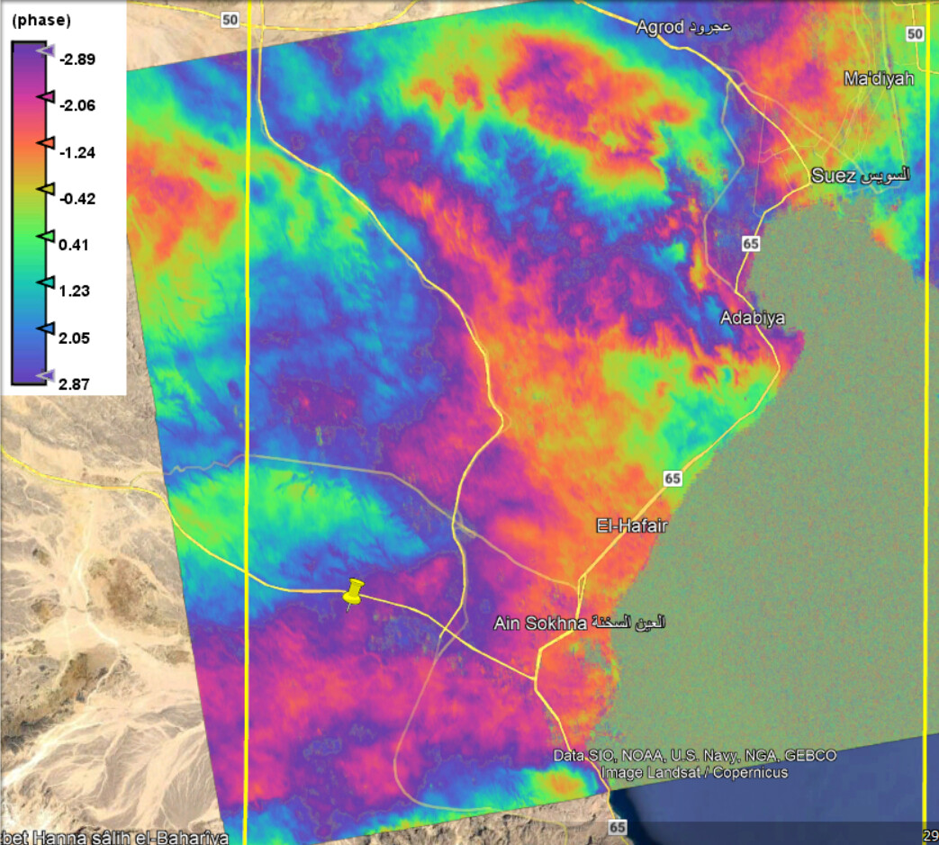
This [14Aug-26Aug 2019] interferogram is for 16-Aug-2019 Earthquake incidence with center depth 20 km and magnitude of 1.9, the epicenter is located at the yellow pin

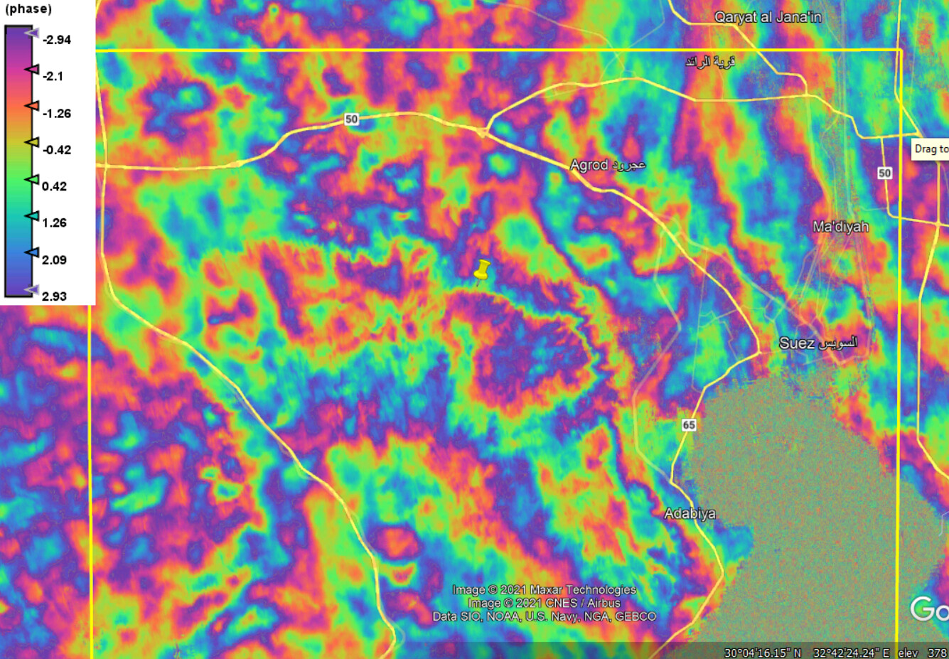
Another [3Feb-15Feb 2019] interferogram is for 7-Feb-2019 earthquake incidence with centre depth 0.1 km and magnitude of 2, the epicenter is located at the yellow pin

I see little relation to the earthquake centres in these interferograms.

Hi @ABraun
I am using the SNAPhu plugin within SNAP. I am totally new and have some problems running that.
After SNAPhu exporting, I will have the file as below image.


And then use the highlighted file in order to do the unwrapping. The problem is that the process runs forever! after 4 hours I got only 7% progress. Could you please help me to figure it out? Thank you in advance

your raster file is over 1 gigabyte of size. Depending on the number of tiles, the number of processors and the overlap you selected, this can take a considerable time. So if there is progress during the unwrapping, all you can do is wait, reduce the raster size before unwrapping (multi-looking or subset) or switch to a faster PC.

1 Like

Currently I do not have access to SAR data besides Sentinel 1 images; but if I may ask, what if I try creating an interferogram using X-band or L-band-based images? Would the change in the wavelength possibly affect the interferogram patterns?

Larger wavelengths interact with different surfaces and are less prone to temporal decorrelation. I can’t promise that it will look better. There is probably too much vegetation in your area, which is always bad for InSAR.

Thank you so much.

I can confirm that there’s vegetation in some areas covered by those interferogram examples shown above, however their extension is very limited as the area west of the gulf is mostly arid rocky desert with occasional flash floods.

But I am interested to know your opinion of how an interferogram would look like if there was no ground motions whatsoever in between the two dates of the SLC pairs

In other words, How can I make a judgment whether the interferogram quality reflects no ground changes, processing error, atmospheric disturbances or temporal decorrelation?

Would clipping the image before the interferogram creation step make any difference in the interference patterns?

I have tried sub-setting after co-registration then I have received this error while creating the interferogram from the subset product

doesn’t make sense to me that the subset of the stack won’t work. Did you save it as BEAM DIMAP?
You can skip the topo phase removal and directly perform this during the interferogram formation step.

Yes, I did

I already skipped it and also tried the same process on another subset from a different stack image and yet the same error popped up

Hello I am beginner at InSAR

I have a question about SNAPHU. When I run below command :
snaphu ddiff.adf.adf_pha.geo.nn -c ddiff.adf.adf.cc.geo.nn -o ddiff.adf.adf.geo.unw 3867 -f config_snaphu

I take this error:
snaphu v2.0.3b0.0.1
9 parameters input from file config_snaphu (10 lines total)
Reading wrapped phase from file ddiff.adf.adf_pha.geo.nn
No weight file specified. Assuming uniform weights
Reading correlation data from file ddiff.adf.adf.cc.geo.nn
File ddiff.adf.adf.cc.geo.nn wrong size (2347x3867 array expected)
Abort

When I geocode interferogram and cc, they become same size (70M)

I hope this is the best thread to ask. Is this folder (Snaphu_tiles_----) needed after Snaphu Import? It takes up significant space

no, you can delete it after successful import.

Like this?

In my case, this is the raster size

Setting tiles of rows and column 10x10 with overlap size 200x200 created this unwrapped phase pattern