Hello,
I have found a previous post in STEP Forum indicating that values a bit higher than 1 for Sentinel 2 surface reflectance are still valid which maybe be at certain extent and for a number of pixels the result of reflective properties of some specific material such as metals, snow or maybe some minerals or sand etc. However my question is whether the maximum value of 1.8 is still valid, meaning the interval [0 1.8 ] for surface reflectance specially for the Green band ‘B3’, could be consider valid ? and if not, is it recommended to set to NaN all values over 1 or directly recalculate the surface reflectance for all the image expecting that this possible offset pixels disappear?
Thanks a lot for your help and suggestions.
Gabriel
It could be useful to mention the image where you found the high values so others can see the problem. Are you interested in land or ocean products? Did you use an existing data set (e.g., the L2A files from Copernicus) or calculate the values yourself?
Hello,
Thanks very much for your replay. I used Google Earth Engine for downloading the image since corresponds to a large region of interest. The image corresponds to the green band ‘B3’ of Sentinel 2 Level 2 for an extensive very large region of interest in the Mediterranean land of Middle East downloaded from Google Earth Engine employing cloud probability mask as is in the code at : https://developers.google.com/earth-engine/datasets/catalog/COPERNICUS_S2_CLOUD_PROBABILITY afterwards also a water mask was applied for removing water bodies in the continental land and the sea, then the band was rescaled according to the correspondent recalling factor 0.0001 and clipped for the region of interest for exporting it as GeoTIFF file. After exporting to Google Drive the resulting cloud and water masked band ‘B3’ was automatically splitted into 6 GeoTIFF files by Google Earth Engine which were afterwards converted back into a mosaic using QGIS.
That would be quite a lot of work to replicate. Can you give dates and locations for a few pixels with high SR values? You may get better answers from Earth-Engine Help. In addition to the well known causes of high SR (e.g., reflective roofs, salt flats, etc.) some farms use white ground cover fabric to protect crops (from late frosts in Canada) insects.
I agree that this happens in some cases: TOA Range in Sentinel-2 Images between 0 an 1?
A value of 1.8 should not occur throughout the entire image but is still reasonable as an outlier.
I suggest that you ask Google Earth Engine for help. This is a forum for SNAP and the toolboxes not for GEE. Discussing general Earth Observation is okay, but the focus of the forum should still be the software.
Proper reflectance = Exitance / Irradiance
Sentinel-2 (pseudo-)reflectance = Exiting Radiance / Irradiance (unit can be sr-1 or if multiplied by Pi is unitless)
under Lambertian assumption you will have equality between the two types of Reflectance
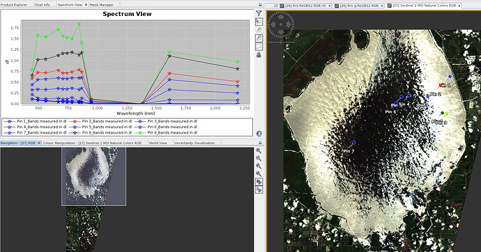
when you a very peaked signal in reflectance (see BRDF…) the pseudo-reflectance can largely go beyond one
Example with the famous sunglint:
