SNAP 9.0
I downloaded 2 SLC data and want to do interferogram formation, they are in the same area with different dates:
S1B_IW_SLC__1SDV_20200209T222023_20200209T222051_020198_0263D3_E1F1.SAFE
S1B_IW_SLC__1SDV_20200714T222029_20200714T222057_022473_02AA70_8A46.SAFE
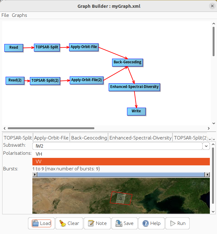
In the TopSAR-Split, I selected the same IW2(VV) and same bursts(1-9), after Apply-Obit-File, Back Geocoding(SRTM 1Sec HGT) and ESD, most parameters are in default.
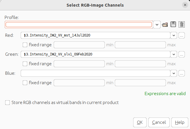
after that, I opend the RGB-Image by:
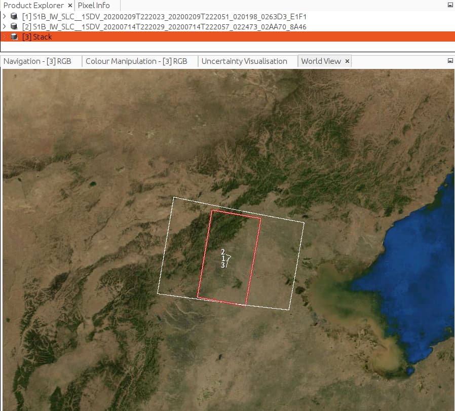
the result is strange: only a few part at the top-left of the area are matching:
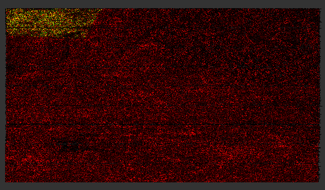
If I select IW3 subswatch, the RGB-Image will all be red points with no intensity data matching.
I checked the orbits data in ~/.snap/auxdata/Orbits/Sentinel-1/POEORB/S1B/2020/ and found:
SLC-2020-02-09:
TAI=2020-02-09T00:00:09.000000
UTC=2020-02-08T23:59:32.000000
UT1=2020-02-08T23:59:31.806758
<Absolute_Orbit>+00007</Absolute_Orbit>
946214.046428
-2615849.791190
-6512830.935658
-559.833411
-7031.570056
2743.997866
NOMINAL
…
SLC-2020-07-14:
TAI=2020-07-14T00:00:09.000000
UTC=2020-07-13T23:59:32.000000
UT1=2020-07-13T23:59:31.773866
<Absolute_Orbit>+00007</Absolute_Orbit>
949430.917472
-2577671.109300
-6527670.333933
-548.498355
-7047.603902
2704.345295
NOMINAL
…
I think the 2 SLC stacked RGB-Image should be matched in the whole area, because other SLC files(S1A in recent dates) are good.
Did I make any mistakes in this processing?
Thanx!
1 Like
I solved the problem, which can be recreated in these steps:
-
In Graph Builder, set up “Read” → “TOPSAR-Split” → “Apply-Obit-File” → “Back-Geocoding” → “Enhanced-Spectral-Diversity” → “Write” as an normal DEM pre-process.
-
In the “Back-Geocoding” step, Set “Digital-Elevation-Model” as “External DEM” and I selected a local DEM file which has a limited area, for example: “/home/test/dem.tif”
-
Save the task-graph to file ABC.xml and run it
-
Next time, I reused this ABC.xml in another project, in Graph-Builder I modified “Read” files and set “Digital-Elevation-Model” as “SRTM 1Sec HGT(Auto Download)”, saved and run it. But Snap kept on using “/home/test/dem.tif” instead of “SRTM 1Sec HGT”, that caused the problem I mentioned above.
-
In ABC.xml I found:
<parameters class="com.bc.ceres.binding.dom.XppDomElement">
      <demName>SRTM 1Sec HGT</demName>
      ...
      <externalDEMFile>/home/test/dem.tif</externalDEMFile>
      ...
</parameters>
Even I set “SRTM 1Sec HGT(Auto Download)” in Snap, the external-dem-file field has been kept.
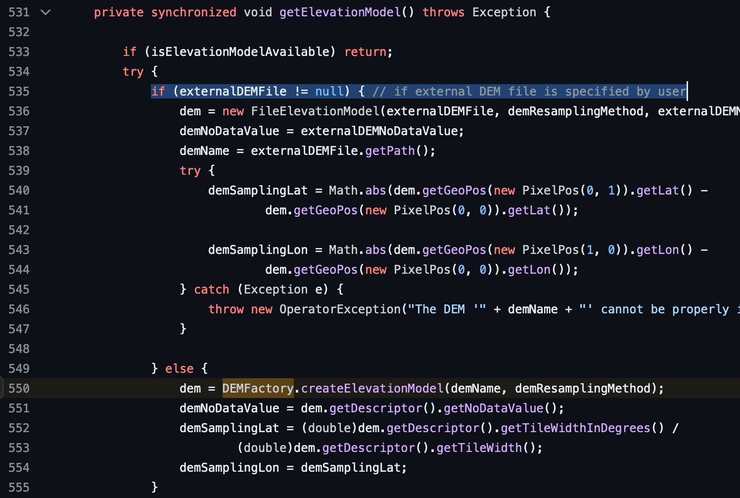
- I checked the source code in GitHub - senbox-org/s1tbx: The Sentinel-1 Toolbox
BackGeocodingOp.java
Line 535 shows: Snap will check external-dem-file field in ABC.xml first and ignore whatever we set to “Digital-Elevation-Model” in Graph-Builder
- After I delete this line in ABC.xml:
<externalDEMFile>/home/test/dem.tif</externalDEMFile>
and reload it from Graph-Builder, the problem disappeared.
1 Like
Thank you for reporting this issue.
JIRA ticket SNAP-3603 created