hi, i whant to create a landsubsidence and i have a problem i have mountain in it and when i create displacement it shows wrong info like in mountain where there is nthing it has land subsidence of 1cm and it kind of not making no sense and someparts aregone from map i whant to know if my steps are wrong or not
1-split
2-orbit file
3-back geo coding
4enhance
5-interferomation(i subtract topograpic phase here too)
6-deburst
7-export(using snap8)
8-doing unwraping by cmd
9-import(by snap12)
10-phase to displacement
11-correct terans range
if i am doing wrong tell i try multi looks and topograpic phase removal but it destroy my map completly and i had nothing in displacement
also i whanted to know that if i use java do i get better result
Do you have some sample images you can provide?
I’m playing around with subsidence measurement myself as well. I’ve been using this guide:
I think it works well, but I’ve run into an issue where terrain subtraction is not working as I expected. I was just about to make my own post about that when I saw yours and tought to suggest this guide.
@galloran Is your area of Interest very vegetated? Like does the mountain have vegetation covers?
yeah it is for tehran a city in iran
You are probably experiencing vegetation cover effect. Due to the wavelength of Sentinel-1 C-Band, it may not have penetrated down to the soil. You could try to use ALOS-2 L-Band if it covers your AOI. This way, it should penetrate the vegetation cover and get to the soil.
Also, check your coherence values. If they are low, then it means you cannot rely on the corresponding displacement results.
Typically, good coherence are from 0.3/0.4 above. The closer it tends to 1.0, the more reliable the result is.
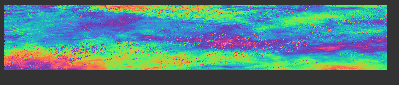
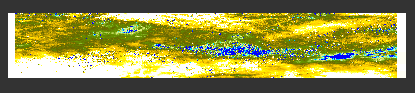
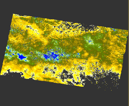
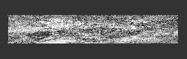
here are my results i just dont get it why are they like these i show it to my boss and he said it is not good and dont hellps it shows displacement but as you can see many places are gone and many of them dos’nt make sense like it says in mountain there is 1cm subsidence it is supposed to be 12 days and i am not sure how is this even possible to have 1cm landsubsidence in 12 days am i wrong or something? any way should i just create 30 more image like these and go for stamps i realy not sure i do many things for these none have given me a good way of land subsidence and i am not sure what i am doing wrong or right here i apreciate hellps for this problem
Are steps different from what I did to sentinel-1 ?
I can see speckles and Edge artifact. The missing parts might be areas where there is no coherence value. Can I see your coherence map? Because the darker it comes, the less accurate it would be. The whiter your coherence map, the more reliable it is. Also using the colour manipulator (Set to table after opening coherence band), can you tell me your coherence values for the White and Gray colour?
A little difference from what I have read but haven’t used it before.
here are result i have a question too do i get better result if i use 12 images instead of 2 image and use time series and stamps in matlb?
i did check ALOS-2-Band it was’nt for iran mostly for china and it was heavy like50g i mean it is too much like i have download 100g for a sinlge displacment map it is just too much
Coherence seems good. Using 12 images would depend on if you are creating a timeseries, Yes. And also depends on how long because the revisit period is 12 days, so you’d be looking at months. This is Small Baseline Subset (SBAS) Technique and you can use StaMPS
The size of the data are one downside to the use of SAR and Remote sensing for the monitoring. You may need additional storage to hold some of your raw data. And Yes, ALOS-2 is mostly China and Japan and my not be available as much for recent years. Although there are commercial coverages that you can pay for. A scene can go as high as 190,000 JPY
I never did a time series so I am new to it do you have experience in it I don’t even know how to begin like what application do I need Matlab gmtsar or something else I also worry about noise I have rightnow in time series method does that stop me from having a good subsidence map and how does it worked I create 12 unwrapped image like one have created here ? Like 2024/06/5 and 2024/06/17 together and then 2024/06/17 and 2024/06/29 together and so on untile I have 12 image and from there I have no idea what to do
You are on track with the combination of SAR images such that you have a master and slave image. I have not used StaMPS for time series but it comes recommended if you know Matlab. I usually create a stack of all image pairs and use SNAP to form a timeseries. There is a “stack overview” option in SNAP that helps to assist with the right selection of the reference master pair and the secondary images, maintaining a less than 150m perpendicular baseline for better accuracy.
So I combine all 12 unwrapped image and then use stamps? Should master be first image right?
Well, not familiar with StaMPS but that is the way. You may not need to unwrap them. SNAP2StaMPS can do the unwrapping too. Just watch some YouTube Videos from Dr. DINH HO TONG MINH, he has some resources and Tutorials that might help you understand how StaMPS work.
1 Like