Another thing I need to ask you.
In the table the “Bperp (m)” is it the perpendicular baseline value? Then why in negative - value?
yes, it is given relative to the orbit of the constellation. Its net length is still 303 meters
@ABraun
Thank you for your reply.
Another question, is it possible the HoA value also be negative?
wouldn’t make sense to me but maybe a simple computational glitch. As long as the value is within a reasonable range.
1 Like
@ABraun
I see, as long there is reasonable value. Thank you
I have another question.
I noticed the Coherence images generated are not uniform, some brighter and darker.
What could be the reason and meaning to these variations.
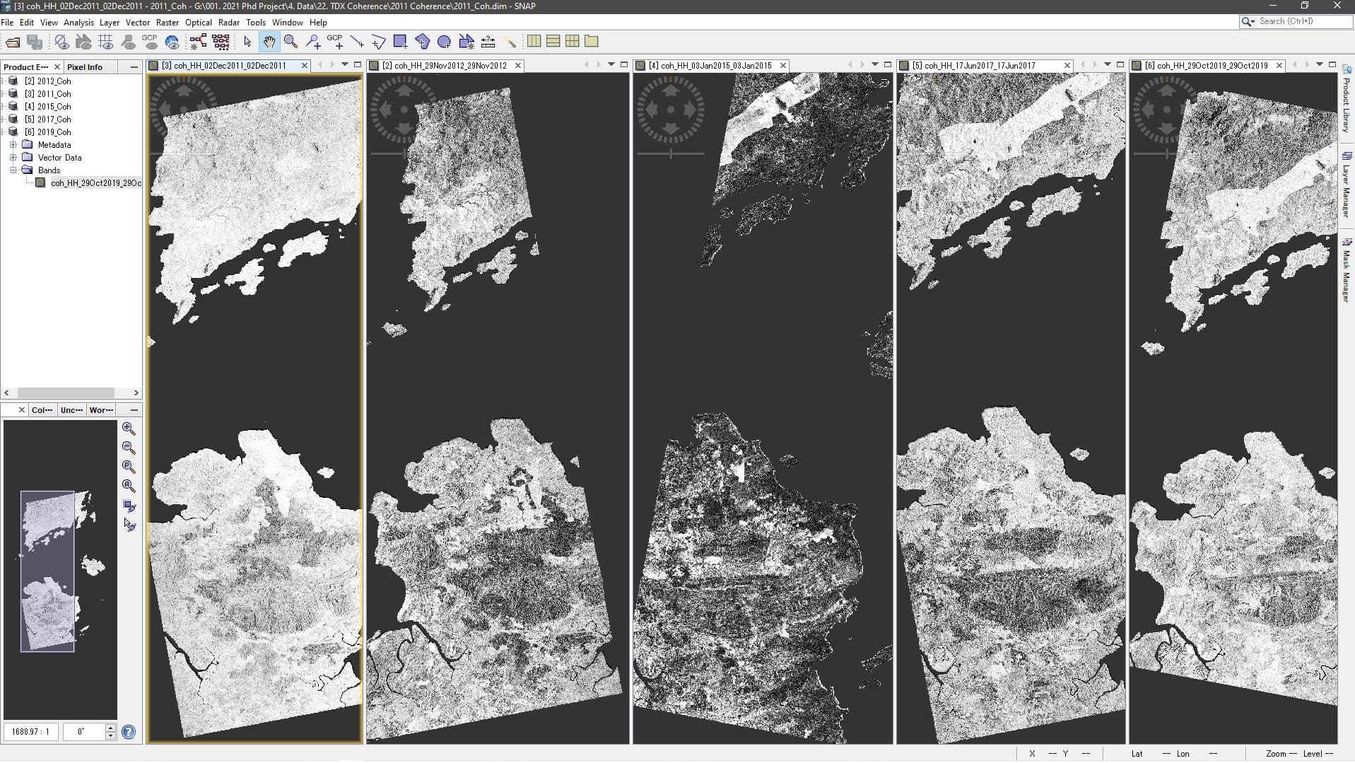
I see several reasons
- SNAP adjusts the contrasts according to image statistics, so please make sure all your images are scaled between 0 and 1 (or 0.7) in the Color Manipulation tab
- the images are acquired from different tracks and look directions. Many surfaces are sensitive towards the angle of the incoming signal, and so is the computed coherence
- moisture and other factors at the time of image acquisition affect coherence
- motion or displacement
There are publications discussing these aspects
1 Like
Longer baselines cause more volume decorrelation, could you plot baseline-lenght vs. average coherence?
ps. your dataset looks promising from a coherence-exploitation perspective. Land-cover classification should work out pretty well.
2 Likes
Right, the image from January 2015 falls into the time where the perpendicular baseline was gradually extended from 750 m to 4 km during the experimental large baseline phase
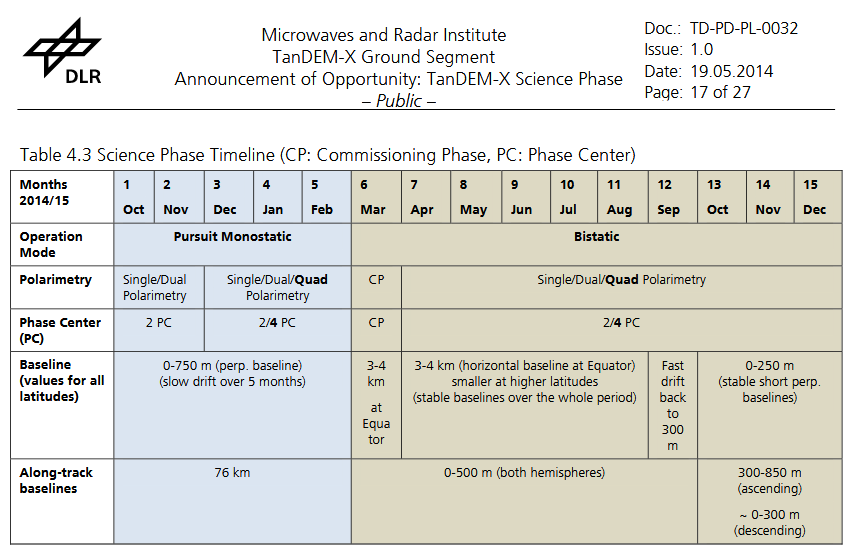
source: https://tandemx-science.dlr.de/pdfs/TD-PD-PL_0032TanDEM-X_Science_Phase.pdf
2 Likes
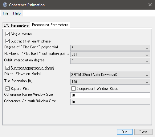
Just want to ask your opinion, is there any standard guide for the 1. subtract flat-earth phase, 2. Subtract topographic phase & 3. Square pixel recommended/standard setting I should choose when doing the TanDEM-X data coherence estimation?
Thank you
Depends on what you want to do with the coherence afterwards.
In most of my cases, removing the topographic component didn’t have a strong effect on coherence (more on the interferogram), but you could easily calculate one with and one without removal and visually compare which you like best. But use SRTM 1Sec (AutoDownload) as it has better resolution.
You can leave flat-earth-phase removal by standard.
Thank you for your reply.
Just wonder what is the meaning of this SRTM1Sec HGT.
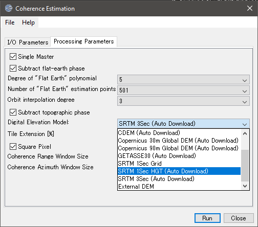
SRTM comes in two resolutions 3Sec (90m) and 1Sec (30m). From the latter, one is for automated download, the other option is selected when you have downloaded them yourself.
Ya, I know 1sec is 30m but wonder what is HGT means. Anyway, I will just try and see the comparison. Thanks @ABraun
HGT results from the NASA terminology:
The SRTM data files have names like “N34W119.hgt”. What do the letters and numbers refer to, and what is “.hgt” format?
Each data file covers a one-degree-of-latitude by one-degree-of-longitude block of Earth’s surface. The first seven characters indicate the southwest corner of the block, with N, S, E, and W referring to north, south, east, and west. Thus, the “N34W119.hgt” file covers latitudes 34 to 35 North and longitudes 118-119 West (this file includes downtown Los Angeles, California). The filename extension “.hgt” simply stands for the word “height”, meaning elevation. It is NOT a format type. These files are in “raw” format (no headers and not compressed), 16-bit signed integers, elevation measured in meters above sea level, in a “geographic” (latitude and longitude array) projection, with data voids indicated by -32768. International 3-arc-second files have 1201 columns and 1201 rows of data, with a total filesize of 2,884,802 bytes ( = 1201 x 1201 x 2). United States 1-arc-second files have 3601 columns and 3601 rows of data, with a total filesize of 25,934,402 bytes ( = 3601 x 3601 x 2).
1 Like