Regarding damage detection in urban area using TerraSAR-X data;
I have three TerraSAR-X images with resolution 2.62 m of orbit 39.
TSX1_SAR__SSC______SM_S_SRA_20090817T153008_20090817T153016
TSX1_SAR__SSC______SM_S_SRA_20150530T153034_20150530T153042
TSX1_SAR__SSC______SM_S_SRA_20151225T153038_20151225T153046
To derive the phase:
I creat two stacks:
First stack: (first & second) images,
second stack (second and third) image
2.using SNAP=>Interferometric=>Product=>Interferogram Formation=>Topographic phase Removal=> Goldstein Phase filtering.
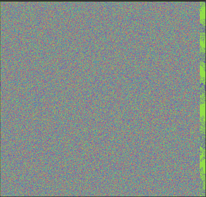
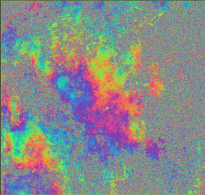
For first stack the phase looks like noise
While the phase for the second stack looks very good
Kindly help me to figure out how I can derive a coherence phase for the first stack not noise as I have.
Probably also the Bperp is much difference. Sometime, even if it looks like noise, you should zoom in to see better. Do you have by change also the interferometric coherence computed?
with Bperp I meant perpendicular baseline.
Normally TSX is controlled for taking orbits suitable for DInSAR.
Could you please provide more info about the processing of the noisy interferogram?
Actually I do not know how to calculate Bperp.
The processing to derive the interferogram
using SNAP=>Interferometric=>Product=>Interferogram Formation=>Topographic phase Removal=> Goldstein Phase filtering.
no further process has done after I got this noisy image
If you open SNAP from terminal, then this info is logged on the terminal screen. You can always open both images within SNAP and use the InSAR overview operator (same for selecting master image within a image stack) and get the Bperp information.
In such case it seems indeed that everything might be related to Btemp, but I am still not convinces. Which kind of environment are you working on? Urban? Rural? Montains? Agricultural?