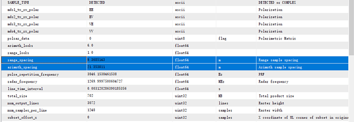
Are the slant range and azimuthal spacing of each pixel supposed to be the same or is the variation negligible? Only the fixed values are shown here in SNAP. Because if I want to calculate the ground range spacing, each pixel has a different incidence angle, so don’t I need to consider the different slope and azimuthal spacing of each pixel?
@ ABraun Hi, Dear friend, Hope you can answer this stupid question
Slant-to-ground range conversion takes care of that … you can find it under radar/geometry/…
Thanks for your reply. I found it, but I was trying to get the (azimuth, slant range) pixel spacing and do a slope calculation based on what’s underneath, not sure if they are the same or different for each pixel, in SNAP I can only see one value.
"Given an input DEM in radar (azimuth, slant range) coordinates, the DEM
pixel spacing (in azimuth and slant range), and the incidence angle,
calculate and return the azimuth and ground range slope angles (in
radians).

Arguments:
    dem: an array containing the DEM heights.
    spacing: a tuple containing the (azimuth, slant range) pixel spacing
        of the DEM, in meters.
    inc: the incidence angle, in radians.

Returns:
    rngslope: the terrain slope angle in the ground range direction
    azslope: the slope angle in the azimuth direction

"""
(azslope,rngslope) = np.gradient(dem)

azslope = np.arctan(azslope / spacing[0])
rngslope = np.arctan(rngslope / ((spacing[1]/np.sin(inc)) + (rngslope/np.tan(inc))))"It is not clear what you are trying to achieve. If you want to refer to angles rerived from a DEM, you’ll need to terrain-correct the image using the DEM.
