Hi everyone
I am working with Sentinel 2A images and I need to do the topographic corrections (Minnaert correction) using the solar position data: azimuth and height? I have only one question: what is the correct data for complete scene? For example, my scene is “fce5150f-f930-4488-b57a-a4067c00b477” (Date:2016-06-23T10:58:58Z). I’m not sure because of there are different data about solar position. This is the first time I work with Sentinel 2A data.<img
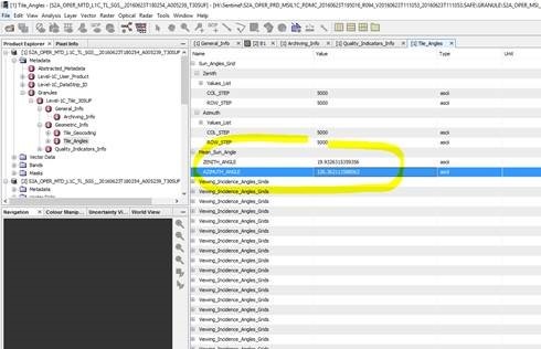
I am using SNAP and SAGA GIS (The topographic correction module). The Saga module demands azimuth and height.
Regards