I am a private individual who needs to obtain a satellite view of a particular plot of land at specific dates. I have already exploited all images I could readily find online (Google Earth Pro, Geoportail and such), but in trying to find some more interesting data, I found that Sentinel-1 offered more data still.
The only problem is I have no clue about how to process these images to obtain something similar to what you see when you open Google Earth. I downloaded Snap and followed their guidelines as well as the instructions of some forum posts. Unfortunately, there is always something which does not work on my side, and not knowing what each step actually does makes it impossible for me to circumvent these failures.
I just need to understand how to obtain a simple satellite view (such as you could find on Google Earth), in as high a ground resolution as possible, for a plot of ca. 20 ha. But given my knowledge, this will probably take multiple exchanges
Would there be a generous soul willing to help me out?
I thank you all very much in advance for your kind help.
You should start by learning some SAR basics so you understand how SAR images are created. How successful you can be depends on the topography, vegetation, shape of your area of interest, and the type of changes you hope to measure.
This background will help you get more out of tutorials for SNAP and Sentinel 1..
Thanks for your reply.
I will try to look into this, but at the first glance I can tell it will probably be too technical for me.
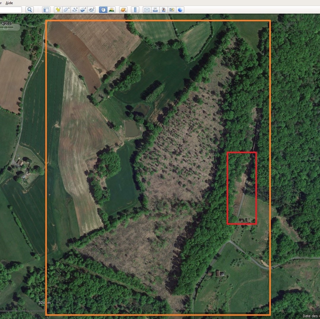
What I need is to know what I should do in Snap to turn the files I download from Copernicus into images like the one below, with the best possible resolution.
What I’m interested in here is measuring at what pace this forest was cut down, and to estimate the area of the log pile in the red square. I already have two pictures at two different dates, but I would need a few more.
You could probably achiieve your goals via using free platforms, for example EO Browser that has both Sentinel-1 and Sentinel-2 data globally. You don’t need to do any complex processing as that has already been taken care of.
Thanks for the tip.
I went and looked for Sentinel-1 data on the EO browser.
However, what turns up for the same plot of land is something like below, which is totally unusable for me. Do the Sentinels not deliver images in real color and in sufficient resolution to get something like the image I posted above, or am I just handling it wrong?
Wow, thanks for letting me know.
All right, I searched for Sentinel 2 images. Unfortunately, the resolution is way too low for what I need, I would need a resolution of 1,5m or higher.
Would you know whether there are any other available satellites out there which might provide higher resolution?
The resolution available on Google Earth Pro, for instance, is really great. But I don’t know which satellite(s) were used for that, and where to search for their images.
Imagery of this high resolution is usually not freely available. Sentinel-2 has the highest resolution of free data, as far as I know. But you can buy data of higher resolution, e.g. here:
Then there are commercial platforms where one can buy access to high resolution commercial data in a simplified manner, without having to deal with satellite image providers directly, for example:
Thank you so much for your info. Thanks to you, I was able to progress a lot in my search and could find some more images that would be of interest to me.
The only downside is the price: I am particularly interested in two Gaofen-2 images, but at over $200 apiece (given that I’m below the minimum order area of 25 sq km, I would pay the minimum price), this is much too expensive for me.
It would seem that EarthCache, which mengdahl mentioned, has much more affordable pricing. Unfortunately, it seems they do not work with Gaofen-2 imagery.
Would any of you know of any platform that might let me buy Gaofen-2 imagery at more affordable prices (max $100 apiece)?
Hello, sorry, I didn’t find how to create a topic on your forum. I’m more used to the old forums. I have been working with optical and radar satellite data of various resolutions for 13 years, especially according to sentinel data. In recent years, many dozens of sites with free satellite data have been rapidly disappearing.
Of the sites with fresh images, only Copernicus and eartexplorer were still around. But now Copernicus has started demanding payment.
Searches on the Internet have given me nothing, although I was looking for little. In general, search engines have begun to give me more meager, filtered results. In Russia, all search engines give few sites. Tell me sources of fresh space images.
Thank you