I’d like to go through the compatible of UAV SAR data topic and SNAP open source software once more, I went through all the related topics via this link Search results for 'UAV' - STEP Forum
My questions are:
Once the module of uploading UAV SAR data is available /Do you aware of any?
Is it possible to to use all the the other modules of processing other SAR resources to process the UAV data?
Are you asking about the NASA airborne radar system called UAVSAR or another UAV system? The NASA UAVSAR data is free and open. The UAVSAR family has three different radar instruments that operate at L-band, P-band, and Ka-band. Most of the data is from the L-band instrument and the polarimetric data (full quad-polarization PolSAR) from the L-band UAVSAR is available in a few different formats from the NASA Alaska Satellite Facility (https://search.asf.alaska.edu/). All the data products, including repeat-pass interferometry from the L-band and P-band UAVSAR and single-pass interferometry from the Ka-band UAVSAR are available from the JPL website https://uavsar.jpl.nasa.gov.
I don’t know whether SNAP software supports any of the NASA UAVSAR data products. The NASA-JPL InSAR Scientific Computing Environment (ISCE) software supports UAVSAR products.
The second question is, Is amplitude product equal to multi-look complex?
Now coming back to my main question what I’m looking for is,
Is it possible to process any UAV SAR data using SNAP once the module of uploading the data is available?
In other words, once the images is uploaded is it possible to apply the modules of other SAR data for the specific UAV SAR?
The NASA UAVSAR products for the PolSAR data are provided as multi-look complex files for the original four polarizations and in a number of detected products that are amplitudes of specific polarizations such as HHHH or HVHV.
The full resolution SLC products for UAVSAR are huge, more than 20 GB for most lines, so they are not kept online. The UAVSAR L-band online SLC products are the coregistered SLC stacks that are cut into segments that are 50 km long. These can be processed with the ISCE2 stripmapStack workflow. There are also SLC products in the NISAR-like format HDF5 files that have been specially filtered to be at the NISAR resolution and radar bandwidth. These can also be processed with ISCE (version 2 or version 3). I don’t know if SNAP supports the NISAR format files yet.
No, the UAVSAR airborne data processing to make the PolSAR, Repeat-pass Interferometry, and SLC stack products is done with a different JPL software package that is not Open Source. Handling the airborne motion compensation is very different from spaceborne SAR. The UAVSAR SLC stacks have all the platform motion and topographic phase corrected and are in a common coordinate system that is the same as regular stripmap data, so the SLC stack products can be processed to interferograms with ISCE2.
When we run the UAVSAR SLC stack products through the ISCE2 stripmapStack workflow, one of the data products is the interferometric coherence in addition to the interferograms. Because the SLC stack is already precisely coregistered, it is very easy to calculate the interferograms and coherence.
In most places, you can use any polarization of the UAVSAR data to map water bodies, as the radar backscatter is very low in all polarizations. In a few places, there might be more radio frequency interference at certain polarizations, so the higher signal-to-noise ratio of the HHHH polarization Ground-range Detected (GRD) products are probably better.
Dear Sir,
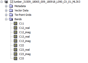
Sorry for my redundant questions, but I’d like to ask you about meaning of each item within the grd L band UAVSAR, I know it’s covariance matrix but I didn’t find any details. The following is the screenshot
And what kind of preprocess I could apply via SNAP.
@EJFielding I downloaded the following file Rosamd_35012_16074_005_160920_L090VV_04_BC_s1_1x1.slc from the UAV SAR website, but I am currently unable to find a suitable reader. Could you recommend a reader that can open this file?
Additionally, I obtained this SLC data for the purpose of estimating absolute radiometric calibration constants.Is this file in original DN or scaled DN? Thank you
It looks like you downloaded one of the SLC images from the UAVSAR SLC stack processing. The UAVSAR SLC stack products are floating point values as a plain flat file and the site should include a “.ann” file for each SLC image that provides information on the image sizes and calibration constants. I work only with InSAR analysis, so I don’t calculate the absolute radiometric calibration because I only care about the phase, but I use the ISCE2 “stripmapStack” workflow to perform interferometric analysis. I don’t know if that code will do the absolulte radiometric calculations.