I am getting inconsistent results when using the Geometric --> Range Doppler Terrain Correction to obtain Gamma0 images. The input is S1A IW GRD products. Sometimes the routine works with no issues. Sometimes Gamma0 generation fails and I only get a Sigma0. No errors are reported in this case.
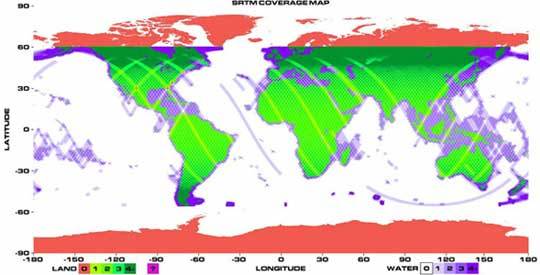
My internet connection is pretty good but I wonder if there is a way to check where the SRTM DEM from auto-download is stored? Is SNAP perhaps looking for a DEM file and failing once it finds that it doesn’t cover the whole scene?
Yes, same location. The routine doesn’t show any errors but the gamma naught band is never produced. It’s making a local incidence angle for me so it’s reading the DEM. I’m currently using that band to calculate gamma naught.
that’s an OK solution, but the radiometric terrain flattering routine doesn’t use the same method (facet) as the Range Doppler Terrain Correction. I may be misunderstanding the outputs of the Range Doppler Terrain Correction. A Gamma Naught image is produced, but it’s a “virtual band”. How can I export it to geotiff?