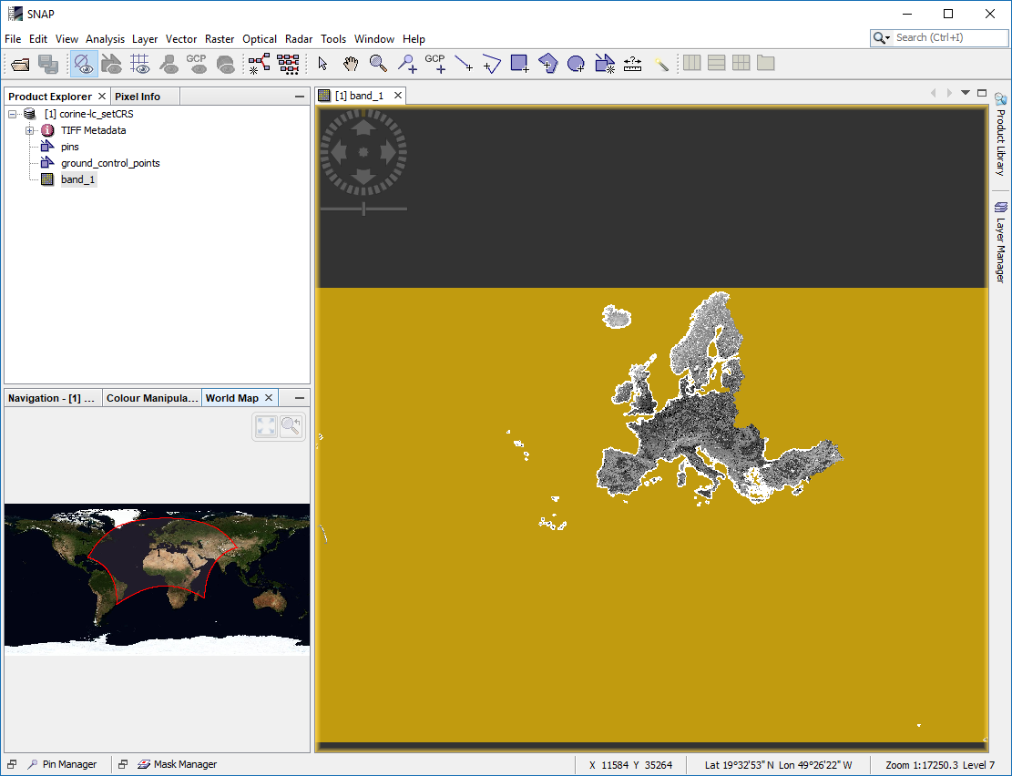
I’ve downloaded the Corine 2012 Land Cover map from this link Corine:
The projection is obviously in ETRS89 (EPSG:3035)but I’m unable to make a subset of it in Snap because of the projection. Below is the error I got in Snap:
java.lang.IllegalArgumentException: illegal value for parameter 'geo_lat1': Value must be in the range -90.0 to 90.0.
	at org.esa.snap.core.param.Parameter.handleParamException(Parameter.java:487)
	at org.esa.snap.core.param.Parameter.setValue(Parameter.java:177)
	at org.esa.snap.ui.product.ProductSubsetDialog$SpatialSubsetPane.syncLatLonWithXYParams(ProductSubsetDialog.java:952)
	at org.esa.snap.ui.product.ProductSubsetDialog$SpatialSubsetPane.addGeoParameter(ProductSubsetDialog.java:824)
	at org.esa.snap.ui.product.ProductSubsetDialog$SpatialSubsetPane.initParameters(ProductSubsetDialog.java:789)
	at org.esa.snap.ui.product.ProductSubsetDialog$SpatialSubsetPane.<init>(ProductSubsetDialog.java:512)
	at org.esa.snap.ui.product.ProductSubsetDialog$SpatialSubsetPane.<init>(ProductSubsetDialog.java:487)
	at org.esa.snap.ui.product.ProductSubsetDialog.createSpatialSubsetPane(ProductSubsetDialog.java:395)
	at org.esa.snap.ui.product.ProductSubsetDialog.createUI(ProductSubsetDialog.java:357)
	at org.esa.snap.ui.product.ProductSubsetDialog.<init>(ProductSubsetDialog.java:170)
	at org.esa.snap.ui.product.ProductSubsetDialog.<init>(ProductSubsetDialog.java:148)
	at org.esa.snap.rcp.subset.CreateSubsetAction.createSubset(CreateSubsetAction.java:86)
	at org.esa.snap.rcp.subset.CreateSubsetAction.actionPerformed(CreateSubsetAction.java:64)
[catch] at org.openide.awt.InjectorExactlyOne.actionPerformed(InjectorExactlyOne.java:78)
	at org.openide.awt.ContextAction$Performer.actionPerformed(ContextAction.java:226)
	at org.openide.awt.ContextManager.actionPerformed(ContextManager.java:260)
	at org.openide.awt.ContextAction.actionPerformed(ContextAction.java:109)
	at org.openide.util.actions.ActionInvoker$1.run(ActionInvoker.java:93)
	at org.openide.util.actions.ActionInvoker.doPerformAction(ActionInvoker.java:116)
	at org.openide.util.actions.ActionInvoker.invokeAction(ActionInvoker.java:99)
	at org.openide.awt.GeneralAction$BaseDelAction.actionPerformed(GeneralAction.java:234)
	at javax.swing.AbstractButton.fireActionPerformed(Unknown Source)
	at javax.swing.AbstractButton$Handler.actionPerformed(Unknown Source)
	at javax.swing.DefaultButtonModel.fireActionPerformed(Unknown Source)
	at javax.swing.DefaultButtonModel.setPressed(Unknown Source)
	at javax.swing.AbstractButton.doClick(Unknown Source)
	at com.jidesoft.plaf.vsnet.VsnetMenuItemUI.doClick(Unknown Source)
	at com.jidesoft.plaf.vsnet.VsnetMenuItemUI$MouseInputHandler.mouseReleased(Unknown Source)
	at java.awt.Component.processMouseEvent(Unknown Source)
	at javax.swing.JComponent.processMouseEvent(Unknown Source)
	at java.awt.Component.processEvent(Unknown Source)
	at java.awt.Container.processEvent(Unknown Source)
	at java.awt.Component.dispatchEventImpl(Unknown Source)
	at java.awt.Container.dispatchEventImpl(Unknown Source)
	at java.awt.Component.dispatchEvent(Unknown Source)
	at java.awt.LightweightDispatcher.retargetMouseEvent(Unknown Source)
	at java.awt.LightweightDispatcher.processMouseEvent(Unknown Source)
	at java.awt.LightweightDispatcher.dispatchEvent(Unknown Source)
	at java.awt.Container.dispatchEventImpl(Unknown Source)
	at java.awt.Window.dispatchEventImpl(Unknown Source)
	at java.awt.Component.dispatchEvent(Unknown Source)
	at java.awt.EventQueue.dispatchEventImpl(Unknown Source)
	at java.awt.EventQueue.access$500(Unknown Source)
	at java.awt.EventQueue$3.run(Unknown Source)
	at java.awt.EventQueue$3.run(Unknown Source)
	at java.security.AccessController.doPrivileged(Native Method)
	at java.security.ProtectionDomain$JavaSecurityAccessImpl.doIntersectionPrivilege(Unknown Source)
	at java.security.ProtectionDomain$JavaSecurityAccessImpl.doIntersectionPrivilege(Unknown Source)
	at java.awt.EventQueue$4.run(Unknown Source)
	at java.awt.EventQueue$4.run(Unknown Source)
	at java.security.AccessController.doPrivileged(Native Method)
	at java.security.ProtectionDomain$JavaSecurityAccessImpl.doIntersectionPrivilege(Unknown Source)
	at java.awt.EventQueue.dispatchEvent(Unknown Source)
	at org.netbeans.core.TimableEventQueue.dispatchEvent(TimableEventQueue.java:159)
	at java.awt.EventDispatchThread.pumpOneEventForFilters(Unknown Source)
	at java.awt.EventDispatchThread.pumpEventsForFilter(Unknown Source)
	at java.awt.EventDispatchThread.pumpEventsForHierarchy(Unknown Source)
	at java.awt.EventDispatchThread.pumpEvents(Unknown Source)
	at java.awt.EventDispatchThread.pumpEvents(Unknown Source)
	at java.awt.EventDispatchThread.run(Unknown Source)
I’m unable to reproject this Geotiff file in GrassGIS to WGS84 either. Same thing with gdalwrap with the command line:
gdalwarp -s_srs “EPSG:3035” -t_srs “EPSG:27700” g100_clc12_V18_5a/g100_clc12_V18_5.tif corine-wgs84.tif
I’m not sure how to provide the csv file to the previous command (there’s a csv file inside the Legend folder provided with the land cover map). Here is the error thrown by gdalwrap:
ERROR 4: Unable to open EPSG support file gcs.csv.  Try setting the GDAL_DATA environment variable to point to the directory containing EPSG csv files.
ERROR 1: Translating source or target SRS failed
I need to reproject this image to the WGS84 projection in order to locate an area of interest there.