I have been pre-processing Sentinel-1 GRD imagery with EW swaths using the gpt workflow.
However recently I started seeing an error when opening the pre-processed raster in QGIS. The error shows the projection is unknown and specifically shows the following error:
No transform is available between UnPreformatted textknown CRS: ENGCRS["Arbitrary",EDATUM[""],CS[Cartesian,2],AXIS? and EPSG:4326 - WGS 84. No coordinate operations are available between these two reference systems
The error however, does not show in the SNAP toolbox. The terrain correction has been applied with
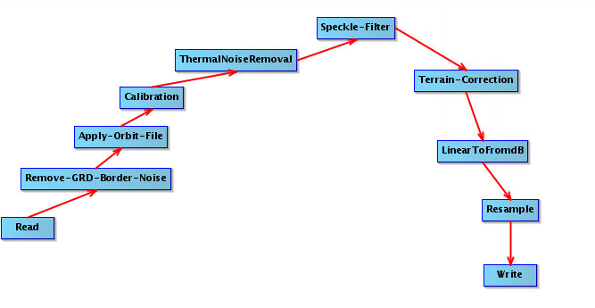
EPSG:3413 in the following workflow scheme.
Even on changing the workflow to a more simple order, the error is still persistent. On the command-line it shows up as following:
I am currently not sure why this issue is occurring. I was earlier using SNAP version 6 and thought that it might have to do with older version, so I switched to SNAP 7, but the issue still exists.
The QGIS bug has a lengthy discussion, include red herrings. If you have been using QGIS through version updates you could have the
problem. To check, you could create a new user login and try running
QGIS in a pristine configuration. If this is the source of your problem, you
should ask the QGIS people for advice. You may be able to remove the problematic entries.
Tangential comment: The resampling-step is probably unnecessary as you can set the pixel-size and coordinate system already at the Terrain-Correction step.
Hi @mengdahl, thanks for the tip! Just to be clear, I do not need the resampling step for changing the pixel spacing from 40 m to 10 m? I thought the step at terrain correction needs to match the pixel spacing of the data and the upsampling needs to happen at the last step. Can you please confirm and elaborate?