hi every one.
please help me to understand step by step urban subsidence process with SNAP or DORIS (specially DORIS ) programs with some images ( e.g. 20 images of one orbit track ) to build subsidence time series ?
please have a look at this tutorial.
https://saredu.dlr.de/unit/insar_deformation
It is based on NEST but most of the tutorial still works the same. However, snaphu is standalone in the meanwhile so unwrapping is easier and works without cygwin or a linux environment.
i found that first step is use of “roi-pac” for orbit and topographic correction and after that (step 2) use DORIS to built interferoram(s) .
after step 2 need to use unwrapping program ( like sanaphu ) for step 3 ?
no, ROI-PAC and DORIS are only required if you work with raw data outside SNAP. You don’t need them if you have SNAP. Simply coregister your images, create an interferogram and unwap it with snaphu.
Thanks .
I want to know subsidence in city due to underground constructions (subway -metro) with InSAR.
1 . I want to know subsidence value before construction start .
2 . I want to know subsidence with during construction .
3 . And subsidence value after construction finished.(for year after it)
I think i should do Dinsar (one master image and another slave- for 15 images).is it correct?
So if it is ok . What should i do (step by step) for dinsar with Snap software?
Does snap use ps or sbas method ?
After all i want compare subsidence values with another softwares ( roi-pac or doris and stamps)
Thanks.
SNAP olny features classic DInSAR, please see here:
You can perform PS with StaMPS, please see here:
If you have the data (enough acquisitions) PS-processing is recommended. Since you are talking about a metro I think we can assume that there are lots of buildings and therefore many Persistent Scatterers.
Thanks . . .
And now what are the right steps to do dinsar with multi images and build times series?
Another question for me is which radar satellite image is precise for this purpse ?
PS processing is possible with Sentinel 1 using SNAP and StaMPS if your timeline is long enough, 20+ images are recommended (Matlab is needed as the only not free available software). You can find some information about the processing workflow in this post and the whole thread the post is within.
Good luck!
Hi.
Thanks Thorsten.
Can do it without matlab programs?
…
And whats the difference betwen NEST and SNAP softwares ?
NEST is the predecessor on SNAP and it’s now obsolete.
Sadly this is not possible, Matlab is necessary when using StaMPS.
anybody should write special matlab code ?
can i found these matlab files on net ?
what matlab code does for stamps ?
what this differenece between VV HH VH HV ??
which one should use for my purpose ?
the matlab code can be downloaded directly with StaMPS
https://homepages.see.leeds.ac.uk/~earahoo/stamps/
Please take a look at the manual: https://homepages.see.leeds.ac.uk/~earahoo/stamps/StaMPS_Manual_v3.3b1.pdf
Polarization doesn’t matter in the first place. The important thing is to select a time-series of suitable images. ESA compiled some excellent documents on this: http://www.esa.int/About_Us/ESA_Publications/InSAR_Principles_Guidelines_for_SAR_Interferometry_Processing_and_Interpretation_br_ESA_TM-19
hi .
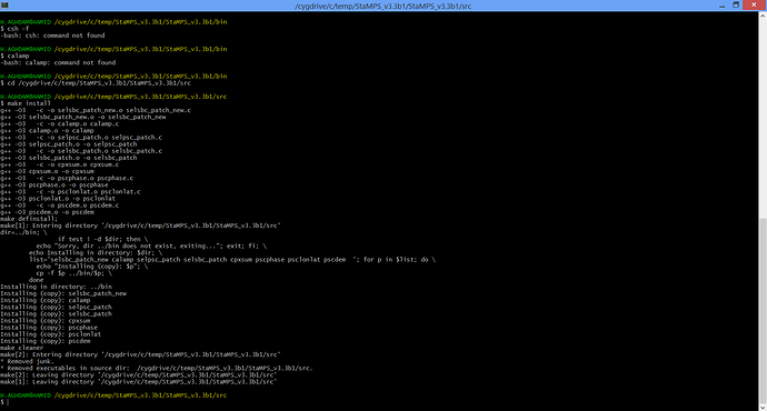
i try to install stamps in cygwin in windows 8.1.
after install , how can i test it ? when i type in /bin folder “mt_prep” , said that " command not found .
the problem is that you would have to extend your bash with the location of the StaMPS scripts so they are callable from any folder (maybe this helps). But that only works properly in Linux. I didn’t see a successful application of StaMPS under Windows so far, there are just too many possible error sources.
If someone got StaMPS to run under Linux I would be interested but you shouldn’t place too much hope in that.
