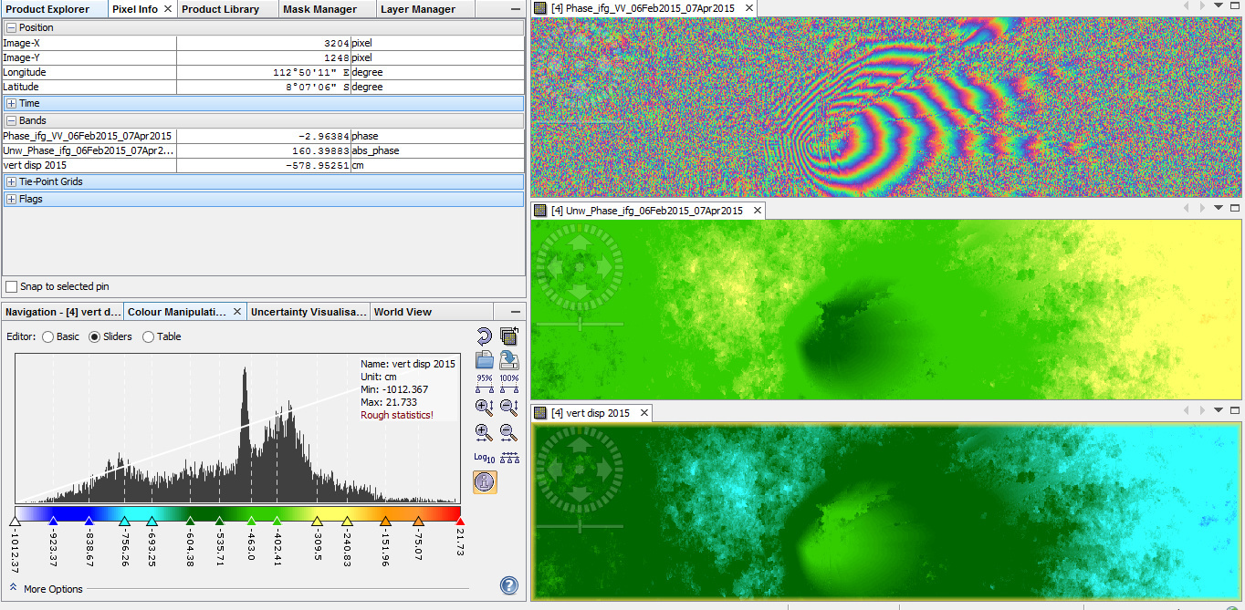
hi everyone, i made vertical displacement map using sentinel 1 06 02 2015 - 07 04 2015, my study area is the highest volcano in Java island, Indonesia. here are the result, which showed the phase, uwrrapping phase, and vertical displacement using band math. the phase band showed the fringe (which i think this is good), but after i calculated vertical displacement with centimeter as unit of measurement the range values are bigger. is this normal result?
usually, the displacement is only measured along the line of sight (LOS).
Which formula did you apply for the calculation? The result has the same units as the wavelength you entered in the equation. For Sentinel-1, entering the wavelength of 5.3 centimeters gives you the result in centimeters. 53 milimeters produces a result in milimeters.
so between vertical displacement and LOS, which is better?
i used formula: phase unwrapping * wavelength/-4PI cos (rad(incident angle)), the wavelenght in centimeter. thankyou
vertical displacement is probably more useful but surely harder to calculate.
Although you shouldn’t trust every pixel, you calculated centimeter values still seem a bit high to me. But I am no expert in volcanism on Java islands.
Hi,
I’m gonna use DInSAR methods to study land subsidence with sentinel 1 iw data, I’m new here and I don’t have much knowledge!i just read a topic and made me this question what is the difference between the result of phase to displacement and vertical displacement(calculating with band math)? Is it necessary to use band math?
Good Day all
I am Okorondu Victor ugochukwu, from Nigeria, a research student of Federal University of Technology Owerri in Imo state. I strongly need guide on how to carry out vertical displacement mapping for Southern Nigeria.
I am new on the use and application of SNAP software in processing sentinel 1 data. I have downloaded sentinel 1 SLC data for 2015 and 2021 of southern Nigeria and was finding it difficult in carrying out preprocessing and subsequent processing for displacement mapping.
first the band of my sentinel 1 SLC data are in i_1w1-VH, q_1w1_VH, intensity_1w1_VH i_1w1-VV, q_1w1_VV, intensity_1w1_VV and W2 and W3 of the same, meanwhile on tutorials, the bands i saw where having amplitude_VH, intensity_VH and amplitude_VV and intensity_VV
Please i want to know if the sentinel data i downloaded is correct? if correct how do i start preprocessing and processing for vertical displacement mapping
when i tried to do terrain flattering after calibration, i was getting report that it cant find the incidence angle tie point grid on the target source product.
You need SLC products for interferometry, maybe you used exta wide (EW) mode instead of the intereferometric (IW) mode? Please have a look at this tutorial which explains all necessary steps. Terrain Flattening is not used in this process. Sentinel-1 TOPS interferometry
Thanks for the tutorial
indeed helpful
i downloaded SLC IW as shown on my attachment
i also applied TOPS Coregistration involving topsar split, apply orbit and back geocoding
my problem started on interferogram formation where i got my output band for phase, intensity and co_IW2_vv to be having the same plain dark colour unlike what i saw on the tutorial
need assistance on how to resolve it
thanks